• Hello, please take a minute to check out our awesome content, contributed by the wonderful members of our community. We hope you'll add your own thoughts and opinions by making a free account!

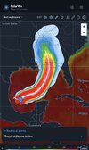
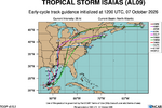
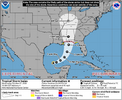
Tropical TS Isaias

ISAIAS_NOAA3_0309A_flw_202610071428.png
 
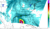
This almost deserves to be Banter but you got to love the long range 3k NAM just out here doing crazy stuff.....918 MB Friday morning umm okay sir

View attachment 198538
I'm going to miss the NAM when it is finally retired later this year. It was useful at times and it could also provide some entertainment value.
 
Tropical Storm Isaias Discussion Number 4
NWS National Hurricane Center Miami FL AL092026
1000 AM CDT Wed Oct 07 2026

Isaias has gotten better organized during the past several hours
with a large area of deep convection near and northeast of the
center. Recent Air Force Hurricane Hunter data indicate that the
center is re-forming a bit to the north of the previous advisory
nearer to the mid-level center, with an estimated pressure of
1000 mb derived from dropsonde data. The initial wind speed is set
to 40 kt in consideration of increase in satellite organization and
the 4-mb dropsonde pressure fall, close to the UW-CIMSS SATCON
values and many of the other objective estimates.

The storm is moving east-northeast at 7 kt. The motion should
gradually bend northward and increase during the next few
days as a trough along the northwestern Gulf coast amplifies and the
subtropical ridge east of Florida builds westward. This pattern
should cause a fast-moving Isaias to approach the northern Gulf
coast by Friday afternoon. Model guidance continues to be
somewhat split, with the AI-based models generally on the right
side of the model envelope, and the physics based models on the
left side. The new NHC forecast is nudged a bit eastward, but
isn't as far east as the latest HFIP Corrected Consensus Approach
(HCCA) or Google DeepMind ensemble mean (GDMI). It is worth noting
that many of the stronger solutions tend to be on the eastern half
of the guidance and faster, which necessitates a variety of watches
at this time.

With the center re-formation, the low- and mid-level centers appear
to be coming into better alignment. This structural change could
facilitate rapid intensification during the next day or two given
light-to-moderate shear along the forecast track, near-record SSTs
for this time of the year and a very moist environment. Near
landfall, increasing shear could cause some weakening, but it isn't
certain how fast the winds will diminish. Regardless, Isaias
should be growing in size as it approaches the northern Gulf coast
due to a trough interaction. The latest guidance is very close to
the last NHC intensity forecast, so little changes were made, and
the NHC prediction is just below the corrected-consensus HCCA.
 
From BMX. They are highlighting the pressure gradient as well. Almost a perfect storm for wind issues: fast moving hurricane becoming extratropical, stiff gradient and still fully leafed out trees. The silver lining is its been dry so that helps some.

Gradient/Tropical Winds:

The magnitude of the wind threat will be highly dependent on the
strength and track of the system. One thing to keep an eye on is
the high pressure system across the northeast resulting in a cold
air damming wedge. This will tighten up the pressure gradient and
cause easterly winds to be quite breezy as the system approaches.
The latest LREF hints at a 60-75% chance for gusts greater than
30 MPH on Saturday. At minimum, would expect at least a wind
advisory with this system and associated potential for downed
trees and power outages.
 
Back
Top