• Hello, please take a minute to check out our awesome content, contributed by the wonderful members of our community. We hope you'll add your own thoughts and opinions by making a free account!

Tropical 2026 Tropics Thread 🌀

0Z UKMET: 5th run in a row with a Gulf TC with it maxing at a mid level TS and land falling over tip of SE LA followed by MS/AL border on Saturday with plentiful rains and even some areas of flooding rains over the SE US over weekend:

NEW TROPICAL CYCLONE FORECAST TO DEVELOP AFTER 84 HOURS
FORECAST POSITION AT T+ 84 : 23.2N 91.7W

LEAD CENTRAL MAXIMUM WIND
VERIFYING TIME TIME POSITION PRESSURE (MB) SPEED (KNOTS)
-------------- ---- -------- ------------- -------------
1200UTC 08.10.2026 84 23.2N 91.7W 1004 28
0000UTC 09.10.2026 96 22.8N 91.3W 1003 26
1200UTC 09.10.2026 108 25.3N 90.3W 1003 35
0000UTC 10.10.2026 120 26.4N 90.7W 1000 38
1200UTC 10.10.2026 132 29.0N 89.5W 998 45
0000UTC 11.10.2026 144 33.4N 88.1W 992 27
1200UTC 11.10.2026 156 35.4N 87.9W 1002 18
0000UTC 12.10.2026 168 CEASED TRACKING
 
Last edited:
Up to 10/50% as of 1AM CDT advisory:

Tropical Weather Outlook
NWS National Hurricane Center Miami FL
200 AM EDT Mon Oct 5 2026

For the North Atlantic...Caribbean Sea and the Gulf of America:

1. Southwestern Gulf of America:
A surface trough of low pressure has developed along the coast of
Mexico in the southwestern Gulf of America. Although environmental
conditions are expected to be only marginally conducive, gradual
development of this system is possible and a tropical depression
could form by the second half of this week while it initially
drifts eastward before turning northward.
* Formation chance through 48 hours...low...10 percent.
* Formation chance through 7 days...medium...50 percent.

Forecaster Papin
 
Now cherry (30%/70%) as of 8AM EDT:

Tropical Weather Outlook
NWS National Hurricane Center Miami FL
800 AM EDT Mon Oct 5 2026

Southwestern Gulf of America:
A trough of low pressure in the southwestern Gulf of America is
producing disorganized showers and thunderstorms. Although
environmental conditions appear to be marginally conducive, gradual
development is becoming more likely, and a tropical depression is
likely to form during the middle or latter portion of the week. This
system is expected to drift eastward over the next few days, before
it turns northward.
* Formation chance through 48 hours...low...30 percent.
* Formation chance through 7 days...high...70 percent.
 
So the word on the street is here comes another one next weekend! Deep mind AI apparently had something cooking near Cancun .. what say ye?
It is trying to sniff something out.

Some of the WeatherNext 3 members form a storm from the gyre.

WN3 Storm.png

18z GFS operational agrees, its weak, but its there.

GFS next storm.png

Some of the WN3 members make it into the gulf and explode. They then head North into Texas/LA.


WN3 Storm in gulf.png

WeatherNext 2 agrees with WN3, I just dont want to upload so many images.

Before the GFS is trash and fail emojis come, the GFS actually did well with Isaias compared to other non AI models.

.


Just something to keep an eye on for now. This is usually the area where we see stuff develop this time of year.
 
Last edited:
It is absolutely sniffing something out.

Some of the WeatherNext 3 members form a storm from the gyre.

View attachment 198761

18z GFS operational agrees, its weak, but its there.

View attachment 198762

Some of the WN3 members make it into the gulf and explode. They then head North into Texas/LA.


View attachment 198763

WeatherNext 2 agrees with WN3, I just dont want to upload so many images.

Before the GFS is trash and fail emojis come, the GFS actually did well with Isaias compared to other non AI models.

.


Just something to keep an eye on for now. This is the usually the area where we see stuff develop this time of year.
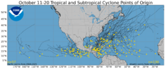

Thanks. Mid Oct climo concurs as it shows numerous TG geneses in the W Caribbean:

IMG_2885.png

 
Oops, I should have put this here the first time:
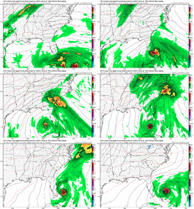
1. Holy cow….984 mb TC on 0Z Icon:
IMG_2923.png

2. It’s also on the 0Z UKMET, the 3rd run in a row with this one a little stronger with a min of 1003 mb/max of 52 knots/60 mph. It forms off of S SC and then moves N into NC OB area followed by a move E offshore and then a S drift as it weakens:

NEW TROPICAL CYCLONE FORECAST TO DEVELOP AFTER 72 HOURS
FORECAST POSITION AT T+ 72 : 32.4N 76.0W

LEAD CENTRAL MAXIMUM WIND
VERIFYING TIME TIME POSITION PRESSURE (MB) SPEED (KNOTS)
-------------- ---- -------- ------------- -------------
0000UTC 18.10.2026 72 32.4N 76.0W 1010 42
1200UTC 18.10.2026 84 34.0N 75.1W 1008 48
0000UTC 19.10.2026 96 32.5N 75.9W 1003 52
1200UTC 19.10.2026 108 34.2N 75.2W 1005 45
0000UTC 20.10.2026 120 36.2N 75.6W 1004 40
1200UTC 20.10.2026 132 36.6N 74.7W 1006 35
0000UTC 21.10.2026 144 36.4N 73.1W 1007 33
1200UTC 21.10.2026 156 35.0N 72.7W 1009 34
0000UTC 22.10.2026 168 32.7N 73.4W 1012 35
 
The 0Z UK is nowhere near the E coast. But it has a very high end TS, which based on the 976 mb SLP might be too low:

NEW TROPICAL CYCLONE FORECAST TO DEVELOP AFTER 36 HOURS
FORECAST POSITION AT T+ 36 : 32.8N 71.4W

LEAD CENTRAL MAXIMUM WIND
VERIFYING TIME TIME POSITION PRESSURE (MB) SPEED (KNOTS)
-------------- ---- -------- ------------- -------------
1200UTC 18.10.2026 36 32.8N 71.4W 1010 44
0000UTC 19.10.2026 48 32.0N 70.5W 1008 42
1200UTC 19.10.2026 60 32.4N 70.3W 1008 39
0000UTC 20.10.2026 72 34.2N 70.2W 1005 39
1200UTC 20.10.2026 84 34.7N 70.0W 1002 40
0000UTC 21.10.2026 96 34.7N 69.9W 1001 41
1200UTC 21.10.2026 108 34.5N 68.9W 1000 39
0000UTC 22.10.2026 120 35.3N 68.6W 997 42
1200UTC 22.10.2026 132 36.5N 67.0W 994 44
0000UTC 23.10.2026 144 38.5N 64.9W 986 56
1200UTC 23.10.2026 156 40.2N 60.6W 980 58
0000UTC 24.10.2026 168 43.3N 53.8W 976 56
 
12Z UK: H in N ATL:

NEW TROPICAL CYCLONE FORECAST TO DEVELOP AFTER 36 HOURS
FORECAST POSITION AT T+ 36 : 32.7N 70.7W

LEAD CENTRAL MAXIMUM WIND
VERIFYING TIME TIME POSITION PRESSURE (MB) SPEED (KNOTS)
-------------- ---- -------- ------------- -------------
0000UTC 19.10.2026 36 32.7N 70.7W 1007 44
1200UTC 19.10.2026 48 33.7N 71.3W 1004 43
0000UTC 20.10.2026 60 35.0N 71.2W 1002 41
1200UTC 20.10.2026 72 36.0N 70.5W 1001 39
0000UTC 21.10.2026 84 36.0N 70.0W 1001 45
1200UTC 21.10.2026 96 36.0N 70.2W 998 42
0000UTC 22.10.2026 108 36.2N 70.5W 996 45
1200UTC 22.10.2026 120 36.9N 69.2W 992 42
0000UTC 23.10.2026 132 38.1N 66.5W 987 48
1200UTC 23.10.2026 144 40.9N 61.1W 978 67
0000UTC 24.10.2026 156 45.8N 56.8W 977 55
1200UTC 24.10.2026 168 47.9N 58.0W 996 43
 
Tropical Weather Outlook
NWS National Hurricane Center Miami FL
800 PM EDT Sat Oct 17 2026

For the North Atlantic...Caribbean Sea and the Gulf of America:

1. Off the East Coast of the United States:
A strong non-tropical low pressure area is expected to form by
Sunday night off the southeast coast of the United States. This low
is likely to move slowly and erratically through the middle of next
week, and some subtropical development is possible during this
time. Regardless of development, this system will cause high winds,
coastal flooding, and dangerous surf along portions of the U.S. East
Coast. Please consult statements and warnings from local National
Weather Service offices and the Weather Prediction Center for more
information, along with High Seas Forecasts issued by the National
Weather Service.
* Formation chance through 48 hours...low...near 0 percent.
* Formation chance through 7 days...low...30 percent.
 
It actually has some support across all ensembles the Gefs eps and their AI all have some shenanigans
Yeah, it's pretty classic, actually. A sprawling HP anchored over the NE, with a lingering frontal trough extending into the Caribbean.
 
POSSIBLE LOW LEVEL INVEST NEAR
36.0N 71.0W FOR 20/1800Z.

12Z UKMET:
NEW TROPICAL CYCLONE FORECAST TO DEVELOP AFTER 6 HOURS
FORECAST POSITION AT T+ 6 : 33.2N 70.3W

LEAD CENTRAL MAXIMUM WIND
VERIFYING TIME TIME POSITION PRESSURE (MB) SPEED (KNOTS)
-------------- ---- -------- ------------- -------------
0000UTC 19.10.2026 12 32.5N 71.3W 1009 43
1200UTC 19.10.2026 24 33.5N 71.3W 1007 42
0000UTC 20.10.2026 36 33.9N 72.0W 1004 41
1200UTC 20.10.2026 48 34.4N 70.9W 1002 36
0000UTC 21.10.2026 60 35.0N 69.5W 1002 37
1200UTC 21.10.2026 72 35.2N 69.0W 1001 40
0000UTC 22.10.2026 84 37.3N 69.5W 996 52
1200UTC 22.10.2026 96 37.3N 68.2W 990 45
0000UTC 23.10.2026 108 38.3N 64.1W 990 39
1200UTC 23.10.2026 120 39.3N 58.6W 991 56
0000UTC 24.10.2026 132 42.2N 49.2W 996 52
1200UTC 24.10.2026 144 48.0N 34.0W 992 40
0000UTC 25.10.2026 156 CEASED TRACKING
 
The non-tropical low now forming gas gone orange:


Tropical Weather Outlook
NWS National Hurricane Center Miami FL
800 PM EDT Sun Oct 18 2026

1. Off the East Coast of the United States:
A storm-force non-tropical low pressure area is developing along a
frontal boundary tonight off the southeast coast of the United
States. This low is likely to move slowly and erratically over the
next couple of days while it initially remains non-tropical. Later
this week, if the system stays over the Gulf Stream, environmental
conditions could become more conducive for the low to develop some
subtropical characteristics. A subtropical cyclone could form over
the second half of this week as the system begins moving generally
northeastward, offshore of the eastern United States. Regardless of
development, this system will cause high winds, coastal flooding,
and dangerous surf along portions of the U.S. East Coast. Please
consult statements and warnings from local National Weather Service
offices and the Weather Prediction Center for more information,
along with High Seas Forecasts and Storm Warnings issued by the
National Weather Service.
* Formation chance through 48 hours...low...near 0 percent.
* Formation chance through 7 days...medium...40 percent.
 
Ensembles maintaining something off the southeast coast with the CMC op run the strongest at 0z.
6Z GFS joins the Canadian. The 0z ICOn and Euro/ukmet all stayed well off east coast. See if they swing back closer mid day runs. 6Z GFS actually goes west with the weak low from north cuba back into GOA. The run is still going, so who knws where she shakes out at. Anyway something to watch this week. You can get crazy things to happen mid-late October with spin ups.
 
Back
Top