JP152
Member
Feb. 83 and Jan. 16 were big dogs.


Been very hostile in November and December on strong ninos with severe weather especially parts south Midsouth .check the pastLate fall early winter events .midsouth had several tornado outbreaks . And this one going be a super Nino , could get interestingView attachment 197956
Strong El Niño December’s are usually pretty hostile towards winter weather in the south, but you do have exceptions to the rule like the December 1982 event
Here’s the preliminary winter outlook from pro met. Chris Martz:
here is my preliminary thinking. . . As y'all probably know by now because of the endless hysteria in the news cycle, we are in an El Niño, which is just the warm phase of the larger El Niño–Southern Oscillation (ENSO). This year, the developing El Niño is unusually intense, and it is expected to officially be a “very strong” El Niño by early winter at the latest. This is marked by very warm sea surface temperatures in the equatorial Pacific Ocean.
The news media and the United Nations have spun this as some sort of crazy event that will “turbocharge” extreme weather all over the globe, but that's not really how it works. Now, normally in the tropical Pacific Ocean, easterly wind stress associated with the Walker Circulation imparted on the sea surface acts to pile warm water near the surface in the western half of the basin; that is, closer to Asia. This pushes the thermocline down towards the west as warm water pools up north of the Maritime Continent and east of the Philippines. But during El Niño, the easterlies weaken or temporarily reverse (westerly wind bursts), which causes that pool of warm water to slosh back east. That's what's happening right now.
There are a lot of meteorological factors to consider when it comes to predicting long-range temperatures, precipitation, and storm tracks. But this year, this “very strong” El Niño will play a dominant role I think as it has in years past (e.g., 1982–83, 1997–98, and 2015–16). Those are my top post-1950 analogs, and I added 1972–73 into the mix as it behaved similarly to the others, although it was only a “strong” El Niño at peak intensity. 1827–28 and 1877–78 would have been good analogs too, but we don't have enough climate data from back then to work with.
A key feature of “very strong” El Niño events is that wintertime temperatures are particularly mild relative to average. This is pronounced in the Upper Plains / Midwest and Great Lakes / Northeast. Temperatures across the Desert Southwest and Four Corners region, however, typically run below average. The southeast can swing either way, but generally winds up near “average” (and I use scare quotes there because the weather is rarely “average”).
However, these exceptionally mild temperatures do not necessarily persist all winter. In fact, most of this composite is due to “blowtorch” Decembers. And I do expect December to end up 5–10°F above average in the areas you see orange and red contours in the first analog composite map I made below.But the roaring Pacific Jet typically relaxes from mid-January through mid-February, so temperatures will tumble a bit closer to “seasonable.” If this El Niño were weaker, there'd be a good chance of a frigid December in the east. But I doubt that's going to happen.
As far as precipitation goes, well, there should be an active subtropical jet stream. So, air parcels moving from west-to-east will tap into Gulf moisture and then be advected northward into the southeast. I expect a lot of rain in the Gulf Coast states (Texas to Florida) and then northward up the east coast into the DMV. Similarly, the western U.S. should expect some major drought relief due to atmospheric river events. After a near-record low snowpack last winter, the ski resorts will be back in business. Elsewhere, it will likely be a bit drier than normal due to persistent high-pressure ridging over the northern flank of the country. Storm tracks are going to favor the southern states.
With respect to snowfall, overall, I do expect less of it nationwide outside of high elevation areas simply due to higher-than-average temperatures. But I cannot rule out ONE crippling blizzard in the Mid-Atlantic or in the southeast. It happened in the southeast (Florida, Georgia, and Carolina coastline) in February 1973 and in the lower Mid-Atlantic (Virginia, D.C., Maryland, and southeastern Pennsylvania) in both February 1983 and January 2016. However, it did not happen in 1827–28 or 1877–78 (I checked NOAA NCEI FORT data) or in 1997–98.
So, whether or not we get the “big one” remains up in the air for now. But it will be that one storm that will ultimately determine where the seasonal snowfall will stand (above / below climatology) in the southeast and Mid-Atlantic. If it occurs, many folks will get their seasonal spoonful of snow in one dumping. If it does not occur, it's just going to be a wet winter.

 www.cbsnews.com

It snowed in December 1997 in much of the South !View attachment 197956
Strong El Niño December’s are usually pretty hostile towards winter weather in the south, but you do have exceptions to the rule like the December 1982 event
Pretty much light event for most and that was bout all winter had offerIt snowed in December 1997 in much of the South !

Melted really quickly tooPretty much light event for most and that was bout all winter had offer
True!It snowed in December 1997 in much of the South !
Not if you live in NE TN. We had over a foot in late January 1997Pretty much light event for most and that was bout all winter had offer
Parts of MS and AL had at least 6 inches. Sadly it fizzled out and I only saw a few flakes in Georgia. But there was another snow event between Christmas and New Years Eve in 1997 and I had an inch or two.Pretty much light event for most and that was bout all winter had offer


View attachment 197956
Strong El Niño December’s are usually pretty hostile towards winter weather in the south, but you do have exceptions to the rule like the December 1982 event

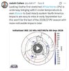
Would that feature cause a stubborn SE ridge during winter ?Biggest thorn in our side this winter is going to be an Omega Block anchoring down over Canada. This is my biggest fear and you can already see it trying to set up shop looking at model loops on the continental view tab out through the end of there runs.
I would think a big ridge would be hard given the Nino.Would that feature cause a stubborn SE ridge during winter ?
Not really. It's position will block cold air transport if its sqaured up over central canada. Now if it squares itself up westward, it could open the artic door. Envision a big west coast ridge spike up the west coast of canada and funneling cold air down through the lakes/ east coast. Few years back we had an omega block that was so fat like first image below, it covered all of canada and sealed our fate.Would that feature cause a stubborn SE ridge during winter ?
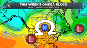
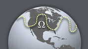
Get a lot of split flows at times with nino's. Which means you end up with a ridge somewhere to our west. Just where exactly and how stubborn or wide etc remains to be seen.I would think a big ridge would be hard given the Nino.
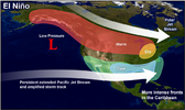
Typically our problem with El Niño, especially the last few, isn’t the SER because the STJ does help to mute it some. The big problem has been the continent getting flooded with Pacific air.Would that feature cause a stubborn SE ridge during winter ?


2beburiedI’m ready

That looks terrible. Wavelengths won't be that short in the winter. A ridge over the central US means get the umbrella drinks ready in the SE.Not really. It's position will block cold air transport if its sqaured up over central canada. Now if it squares itself up westward, it could open the artic door. Envision a big west coast ridge spike up the west coast of canada and funneling cold air down through the lakes/ east coast. Few years back we had an omega block that was so fat like first image below, it covered all of canada and sealed our fate.
Heres a pic for reference.
BAD
View attachment 197980
Heres what we would like to see
Good
View attachment 197981
If Dec comes in BN, then look out. It's on like Donkey Kong!IMO December is the least straight forward month of the winter and easily has the biggest bust potential. Not a lot of signal that the month hangs around average it's either very warm or decently BN. Give me -5-+8 as the forecast.
Yea i was looking for a pic to illustrate prefered ridge location if one pops up and anchors down on us. Only hope would be for it to be way west.That looks terrible. Wavelengths won't be that short in the winter. A ridge over the central US means get the umbrella drinks ready in the SE.


Not so sure it will be wetter than normal either, super el elnino s can go extreme type weather , actually below average precip even for the southeast . A lot watch for .While I think we will have normal or below temps compared to the Climatological averages, it will likely be due to more cloudy rainy days holding the temps down (especially the further down in the SE you go) rather than a lot of cold air flooding the SE. That does not mean we can't score a good snowstorm for areas of the SE but I am afraid the more likely scenario is ice for those from the Upstate North and East except for the Mountains and middle and western Tennessee. Should it be warm in December (and I think it will be) but switch sharply around Christmas, that would put a whole different tone to my prediction
Just out of curiosity, have you found any examples of strong or super El Niño causing below average precipitation in the southeast? I’ve looked back and while it’s varied in amounts, it’s always produced above average precipitation in the examples I’ve found.Not so sure it will be wetter than normal either, super el elnino s can go extreme type weather , actually below average precip even for the southeast . A lot watch for .
I have read bout some situations dating so far back. Would t trust it . InterestingJust out of curiosity, have you found any examples of strong or super El Niño causing below average precipitation in the southeast? I’ve looked back and while it’s varied in amounts, it’s always produced above average precipitation in the examples I’ve found.

Think most of us going cook that s with this super Nino lolAll we need is AK to torch, then we cookin with gas!
For us just 91-92. Most of the strong/supers average out to about an extra months worth of precip of you do djfm, so if you are still in drought this winter probably doesn't erase it by itself. One thing and strong/supers they are prone to a single dry month during the djfm periodJust out of curiosity, have you found any examples of strong or super El Niño causing below average precipitation in the southeast? I’ve looked back and while it’s varied in amounts, it’s always produced above average precipitation in the examples I’ve found.
Hopefully that’s December in this case. Although long range looks like eastern areas stay wetter than my area the entire 4 month span.For us just 91-92. Most of the strong/supers average out to about an extra months worth of precip of you do djfm, so if you are still in drought this winter probably doesn't erase it by itself. One thing and strong/supers they are prone to a single dry month during the djfm period
December has rarely worked out in NC, can only remember 2 snowfalls in my life . 89 and 2010. I’m good with a warm early winter and cold in late January to February. That’s more par for the course!Hopefully that’s December in this case. Although long range looks like eastern areas stay wetter than my area the entire 4 month span.

December has rarely worked out in NC, can only remember 2 snowfalls in my life . 89 and 2010. I’m good with a warm early winter and cold in late January to February. That’s more par for the course!
December has rarely worked out in NC, can only remember 2 snowfalls in my life . 89 and 2010. I’m good with a warm early winter and cold in late January to February. That’s more par for the course!
That’s agreed! I would rather have it late Jan- Feb as that’s what seems to produce the best in these parts!A fairly mild to warm Dec and colder late winter would be par for the course based on W QBO El Niño analogs.

