BrickTamland
Member
I am going to start keeping a total of how many times I actually get a storm when under a watch versus when I am not. Right now it's 1 to 0 in favor of no watch.
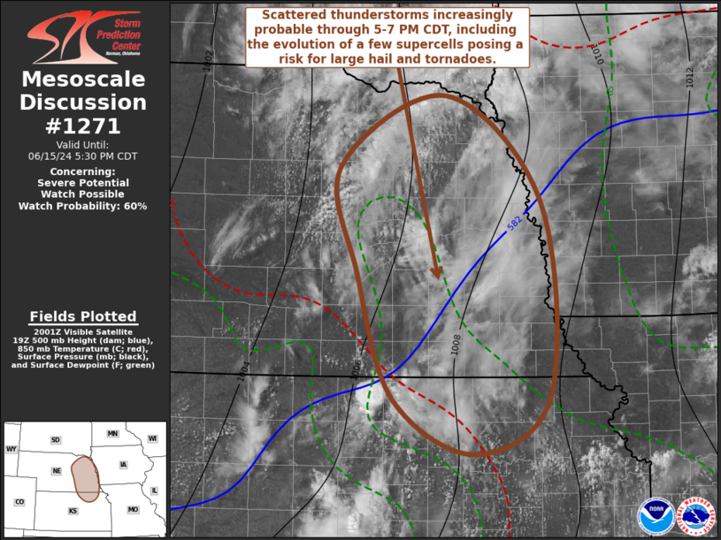

Its going to happen. See MCD#1271.I am going to start keeping a total of how many times I actually get a storm when under a watch versus when I am not. Right now it's 1 to 0 in favor of no watch.

EDIT: GOD ------- ------ SPC! WHY THE HELL DO YOU HAVE TO INCLUDE US?!SEVERE THUNDERSTORM WATCH #381 HAS BEEN ISSUED UNTIL 8PM TONIGHT

I am so glad I am moving out of Harnett county soon. This is becoming ridiculous.EDIT: GOD ------- ------ SPC! WHY THE HELL DO YOU HAVE TO INCLUDE US?!
Heavy rain and lightning now.Heavy Rain in Raleigh!!
Sent from my iPhone using Tapatalk
 ITS RAINING HARD HERE NOW


Buys us some time at least right?I ended up with only .51 inches at my residence near Lake Wheeler outside of Raleigh today. That makes 1.16 inches since Friday which is only a drop in the bucket compared to what we need but it is progress at least.

What part are you at? Always been fascinated at how different the outer banks are weather wise from the “regular” Carolina beaches, especially spring/early summer. Went to Ocracoke awhile back in late May, and it was downright chilly at times.Awesome day on the outer banks today. 74 degrees and breezy. Almost too cool sitting in the shade. Time for a nap….
Apparently it did it again like a minute after the 7.1. 7.5.JUST IN: Tsunami Advisory issued for Puerto Rico and the Virgin Islands after an M 7.1 Earthquake has struck along the coast of Venezuela in the Caribbean Sea.
The US Tsunami Warning Center says
An earthquake with a preliminary magnitude of 7.1 occurred near the coast of venezuela at 6:05 pm ast on wednesday, june 24, 2026.
tsunami threat: based on all available data, there is a tsunami threat to Puerto Rico and the Virgin Islands in the form of sea level fluctuations and strong ocean currents. these could be a hazard along coasts, beaches, in harbors, and in coastal waters.
Estimated arrival time: the earliest estimated time that hazardous sea level fluctuations and strong ocean currents may begin in puerto rico and the virgin islands is 7:19 pm ast on Wednesday, June 24, 2026.
Immediate Actions: actions to protect human life, safety, and property should be taken immediately.
Status updates:
the generation of tsunami waves has not yet been confirmed.
Monitoring is underway to further evaluate the tsunami threat. Stay tuned for advice from local officials.


I worry what these seemingly increased number of quakes is foreshadowingAnd now the USGS now says that a rare “doublet” earthquake occurred in Venezuela, two quakes of similar magnitude in the exact same spot, a 7.5 and a 7.2 earthquake. They say there is the potential of hundreds, if not thousands, of deaths from this earthquake, and serious damage has already been reported, with many building collapses in highly urban areas.

Showoff.

