-
Hello, please take a minute to check out our awesome content, contributed by the wonderful members of our community. We hope you'll add your own thoughts and opinions by making a free account!
You are using an out of date browser. It may not display this or other websites correctly.
You should upgrade or use an alternative browser.
You should upgrade or use an alternative browser.
Misc General Banter Thread
- Thread starter Rain Cold
- Start date
Yeah that's a good point. The lack of snowfall of late has been an abomination.Even another fairly minor (1-2 inch) event would be fun to track. Would be nice if RDU could get to the 1991-2020 snowfall mean for the first time since it has been utilized.
Who broke the Bleaklies? Whereas I haven’t been able to get them all evening, I did look at the WxBell interpretation of them. That suggests they’ve cooled closer to the run from two days ago during several Bleaks fwiw.
WolfpackHomer91
Member
absolutely TERRIBLE news coming from the Pack Extended Family today. Never met him but followed along for years. Was an awesome kid from what I gathered from afar
Sent from my iPhone using Tapatalk
Sent from my iPhone using Tapatalk
That’s really what’s been missing, too. The truth is that 6”+ events have never really been common (I believe 8”+ events happen on just 15% of RDU winters on a long timespan, for example), but we’ve really seen a lack of those 1-4” type systems since ~2015 it seems like.Even another fairly minor (1-2 inch) event would be fun to track. Would be nice if RDU could get to the 1991-2020 snowfall mean for the first time since it has been utilized.
Usmeagle2005
Member
You guys getting hope there will be another chance for winter weather east or west of the apps I feel so bad for  . Just to late in the season. I know it probably happened back in the day in late February or March but the pattern we get now just won’t allow for it, and it will flip back but it’s gonna be late March and too late. Trust me, kills me also. We had some good early/mid March snows, I loved the days when early February you still had a month and a half to be excited for. There will be some chilly days and fantasy storms show up but winter weather is done till next December. I’m hoping next year we get something!
Cad Wedge NC
Member
Yeah, you're probably done for the season down there in MS.You guys getting hope there will be another chance for winter weather east or west of the apps I feel so bad for. Just to late in the season. I know it probably happened back in the day in late February or March but the pattern we get now just won’t allow for it, and it will flip back but it’s gonna be late March and too late. Trust me, kills me also. We had some good early/mid March snows, I loved the days when early February you still had a month and a half to be excited for. There will be some chilly days and fantasy storms show up but winter weather is done till next December. I’m hoping next year we get something!
Brent
Member
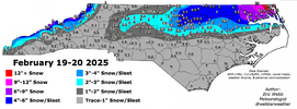
Amazing we've hit our exact average for snow this winter down to the tenth of an inch but looking at the temperature averages....I think we're gonna blow away hottest winter on record at this point. Like it's not even close unless something really changes the end of the month
Is it time to start reminiscing about March 1960, 1983, 1993, or 2009 yet?
Yes, "back in the day", as in less than a year ago.You guys getting hope there will be another chance for winter weather east or west of the apps I feel so bad for. Just to late in the season. I know it probably happened back in the day in late February or March but the pattern we get now just won’t allow for it, and it will flip back but it’s gonna be late March and too late. Trust me, kills me also. We had some good early/mid March snows, I loved the days when early February you still had a month and a half to be excited for. There will be some chilly days and fantasy storms show up but winter weather is done till next December. I’m hoping next year we get something!
Brent
Member
Is it time to start reminiscing about March 1960, 1983, 1993, or 2009 yet?
Way ahead of you haha
I did find 4 of our top 5 snowiest days are in March and now I can't unsee it
There's one year we had a foot in March and that was the only real snow the whole winter!
annoying storm that never got above 25 degrees here in richmond. an under the radar "pissed away a big dog" event from last year. while i think a changing climate has lopped some of the fringes off of when we can "land something", late feb through mid march are fair game and arguably have storms that are more fun to track with shorter wavelengths and more interesting mesoscale dynamics
It is interesting that in the south, March winter storms are about a once-in-a-decade event, but are often big dogs when they occur.Way ahead of you haha
I did find 4 of our top 5 snowiest days are in March and now I can't unsee it
There's one year we had a foot in March and that was the only real snow the whole winter!
On another note, looking through the ensembles over the past few days, it's like Groundhog Day from mid-December with the persistant Alutian ridge. Frigid in Canada while we wait for a pattern change to unleash it into the US.
Yeah, absolutely. I agree our climate has warmed some (indeed, it’s undeniable), but not to the extent that late February and early March aren’t good times for wintry weather here. In the last decade or so, there was also Feb 2020 and the big dog of February 2015, too (and likely some other minor events). It has been a while since we got a good March storm (2009?), but I take that as if we are due and not that it can’t snow in March anymore. Like you said, there’s more potential for big dogs this time of year, if anything, and plenty of late winter cold sloshing around in the North.annoying storm that never got above 25 degrees here in richmond. an under the radar "pissed away a big dog" event from last year. while i think a changing climate has lopped some of the fringes off of when we can "land something", late feb through mid march are fair game and arguably have storms that are more fun to track with shorter wavelengths and more interesting mesoscale dynamics
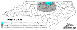
We do wintry weather until May here! Or, erm, well, Roxboro does, anyways.
Yeah, absolutely. I agree our climate has warmed some (indeed, it’s undeniable), but not to the extent that late February and early March aren’t good times for wintry weather here. In the last decade or so, there was also Feb 2020 and the big dog of February 2015, too (and likely some other minor events). It has been a while since we got a good March storm (2009?), but I take that as if we are due and not that it can’t snow in March anymore. Like you said, there’s more potential for big dogs this time of year, if anything, and plenty of late winter cold sloshing around in the North.
We do wintry weather until May here! Or, erm, well, Roxboro does, anyways.
View attachment 194108
Feb 25-Mar 3 have had the highest concentration of big RDU and/or GSO snowstorms since 1950:
Here are the eight 6”+ storms since 1950 at RDU and/or GSO during 2/25-3/3: only 2 of them (25%) were “slop” storms as these were mostly very high/longlasting impact storms
2/26/1952: RDU 3.5”/GSO 6” slop storm
3/2/1960: 6.5” at RDU with high of only 29; 6.1” at GSO with high of only 27
2/26/1963: 6.9” RDU still 3” on ground 2/28
3/1/1969: 9.3” RDU/10.7” GSO: snowcover of 2”+ through 3/4
3/1-2/1980: 11.1” RDU and 7.9” GSO; frigid with teens during snow; 5-9” still on ground 3/4!
2/27/1987: 5.2” RDU/7.5” GSO slop storm
2/26-27/2004: 12–18” Piedmont/Triad area
2/25-26/2015: 5.1” RDU/6.4” GSO
Brent
Member
Yeah, absolutely. I agree our climate has warmed some (indeed, it’s undeniable), but not to the extent that late February and early March aren’t good times for wintry weather here. In the last decade or so, there was also Feb 2020 and the big dog of February 2015, too (and likely some other minor events). It has been a while since we got a good March storm (2009?), but I take that as if we are due and not that it can’t snow in March anymore. Like you said, there’s more potential for big dogs this time of year, if anything, and plenty of late winter cold sloshing around in the North.
We do wintry weather until May here! Or, erm, well, Roxboro does, anyways.
View attachment 194108
We had a trace of snow the same May as the last ef5 tornado here....
Only May on record with snow interestingly
I would agree about March. We had a few chances in both March 2014 and 2018, but none of them turned out to be big dogs outside of the mountains. RDU hasn't had measurable snow in March since then, but a trace of snow on a couple occasions. RDU got around 2" from the March 2009 storm, and only around 1" from the March 1993 storm, so it's been significantly longer since RDU had a true big dog in March. The last one was March 24-25, 1983!Yeah, absolutely. I agree our climate has warmed some (indeed, it’s undeniable), but not to the extent that late February and early March aren’t good times for wintry weather here. In the last decade or so, there was also Feb 2020 and the big dog of February 2015, too (and likely some other minor events). It has been a while since we got a good March storm (2009?), but I take that as if we are due and not that it can’t snow in March anymore. Like you said, there’s more potential for big dogs this time of year, if anything, and plenty of late winter cold sloshing around in the North.
We do wintry weather until May here! Or, erm, well, Roxboro does, anyways.
View attachment 194108
Prior to 2018, I had never seen a big dog before Christmas, and it eventually happened - almost one year exactly after a painful miss. Even in a warming climate, anomalous storms can still happen, so some day we will see a Marvelous March again.
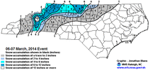
I forgot we did have a pretty bad in situ CAD ZR / sleet storm in March 2014 in the Triad (snow north of us) - we had ~3” of “stuff” and up to a half inch of ZR - super marginal storm that the Euro whiffed on and most of the storm was in the 30-31 degree range. Lost power for several days. But yeah that didn’t affect RDU. And it was in the 60s the day after, which made losing heat less of an issue, hah! Incidentally, there was another nuisance snow event a couple days prior to that and a nuisance IP / ZR event a week after, as well.I would agree about March. We had a few chances in both March 2014 and 2018, but none of them turned out to be big dogs outside of the mountains. RDU hasn't had measurable snow in March since then, but a trace of snow on a couple occasions. RDU got around 2" from the March 2009 storm, and only around 1" from the March 1993 storm, so it's been significantly longer since RDU had a true big dog in March. The last one was March 24-25, 1983!
Prior to 2018, I had never seen a big dog before Christmas, and it eventually happened - almost one year exactly after a painful miss. Even in a warming climate, anomalous storms can still happen, so some day we will see a Marvelous March again.
March 2014 was one of my favorite storms despite the power outage. Love when we get an overperformer like that. We didn’t get a warning until well after the storm was underway. The Euro was a disaster. I think only the NAM and GFS were keying on the possibility the day before. We got a lot more IP than expected, and indeed some areas just north of GSO recorded 6” of snow / sleet.
Like you said about snow before Christmas, leading up to this we thought major ice storms weren’t a thing in March. We were wrong.
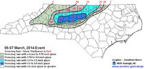
Last edited:
Who broke the Bleaklies? Whereas I haven’t been able to get them all evening, I did look at the WxBell interpretation of them. That suggests they’ve cooled closer to the run from two days ago during several Bleaks fwiw.
Followup: the Bleaklies are back! We can now all rest easy whew!! @Rain Cold
WolfpackHomer91
Member
How do you guys pull the historic Maps or models for previous events ? Like analogs and or just surface maps ect
Here in Raleigh, that March 2014 storm began as a very brief period of sleet, before transitioning to all rain after. We got nearly 3" QPF of cold rain and the temperature hovered around 33-34. It's interesting how much easier it is to get impressive QPF totals when it's raining at 33.I forgot we did have a pretty bad in situ CAD ZR / sleet storm in March 2014 in the Triad (snow north of us) - we had ~3” of “stuff” and up to a half inch of ZR - super marginal storm that the Euro whiffed on and most of the storm was in the 30-31 degree range. Lost power for several days. But yeah that didn’t affect RDU. And it was in the 60s the day after, which made losing heat less of an issue, hah! Incidentally, there was another nuisance snow event a couple days prior to that and a nuisance IP / ZR event a week after, as well.
March 2014 was one of my favorite storms despite the power outage. Love when we get an overperformer like that. We didn’t get a warning until well after the storm was underway. The Euro was a disaster. I think only the NAM and GFS were keying on the possibility the day before. We got a lot more IP than expected, and indeed some areas just north of GSO recorded 6” of snow / sleet.
Hah! So true. You know, it makes me wonder if that could’ve been the highest liquid equivalent winter storm I’ve ever experienced. 3”+ sleet and a half inch of so of ice, with temperatures in the 30-31 degree range, so there must’ve been plenty of runoff from the freezing rain as accrual couldn’t have been super efficient (although it all did fall at night). Surely, we were pushing 2”+ IMBY, tend to doubt I’ve ever experienced a winter storm with more? We also ended as a little light rain after sunrise from what I recall.Here in Raleigh, that March 2014 storm began as a very brief period of sleet, before transitioning to all rain after. We got nearly 3" QPF of cold rain and the temperature hovered around 33-34. It's interesting how much easier it is to get impressive QPF totals when it's raining at 33.
On March 6-7, 2014, RDU had 2.27" QPF. Only a trace of snow, which was mostly sleet.Hah! So true. You know, it makes me wonder if that could’ve been the highest liquid equivalent winter storm I’ve ever experienced. 3”+ sleet and a half inch of so of ice, with temperatures in the 30-31 degree range, so there must’ve been plenty of runoff from the freezing rain as accrual couldn’t have been super efficient (although it all did fall at night). Surely, we were pushing 2”+ IMBY, tend to doubt I’ve ever experienced a winter storm with more? We also ended as a little light rain after sunrise from what I recall.
On January 22, 2016, RDU had 0.95" QPF. Only 1.2" of snow accumulation, much of which was sleet.
On January 6-7, 2017, RDU had 0.85" QPF. Only 0.5" of snow accumulation, much of which was sleet.
On December 8, 2017, RDU had 1.33" QPF. Only 0.3" of snow accumulation, and it was even lower IMBY.
On January 13, 2019, RDU had 1.04" QPF. All cold rain, with temperatures sitting around 33.
On January 16, 2022, RDU had 1.22" QPF but only a trace of snow.
Most of these scenarios had a warm nose and an insufficient atmospheric column for snow, however, RDU was lucky to avoid crippling ice storms in many of these situations. This winter has lacked the high QPF cold rain (which is why we're in a severe drought) but we've seen several events of 1" QPF with temperatures near freezing over the years.
it just has not wanted to get it done this winter QPF wise.On March 6-7, 2014, RDU had 2.27" QPF. Only a trace of snow, which was mostly sleet.
On January 22, 2016, RDU had 0.95" QPF. Only 1.2" of snow accumulation, much of which was sleet.
On January 6-7, 2017, RDU had 0.85" QPF. Only 0.5" of snow accumulation, much of which was sleet.
On December 8, 2017, RDU had 1.33" QPF. Only 0.3" of snow accumulation, and it was even lower IMBY.
On January 13, 2019, RDU had 1.04" QPF. All cold rain, with temperatures sitting around 33.
On January 16, 2022, RDU had 1.22" QPF but only a trace of snow.
Most of these scenarios had a warm nose and an insufficient atmospheric column for snow, however, RDU was lucky to avoid crippling ice storms in many of these situations. This winter has lacked the high QPF cold rain (which is why we're in a severe drought) but we've seen several events of 1" QPF with temperatures near freezing over the years.
How do you guys pull the historic Maps or models for previous events ? Like analogs and or just surface maps etc
There are all sorts of resources available. These include:
Maps: 2003-present

Maps 1948-2011
Daily wx history at RDU, GSO, others
It takes time to put it all together.
Last edited:
I've probably been guilty of giving March too much credit. March and the period from Thanksgiving to Christmas are about the same to me. I might hit a lottery ticket but chances are I'm not, outside of March 2018 I don't remember many mega Marches
The 70s are breaking me. I feel the increase of the chemical known as CAPE in my blood.
One of the more fascinating storms from a local NC climo perspective involving CAD. It’s astounding that places like Hillsborough and Burlington got .5’’ accrual with RDU getting none. Even Durham got in at Ice Storm criteria on the north side. (I’m not even complaining to be honest, as I got my ice fix from Dec 2002. Jealous on the snow/sleet though)I forgot we did have a pretty bad in situ CAD ZR / sleet storm in March 2014 in the Triad (snow north of us) - we had ~3” of “stuff” and up to a half inch of ZR - super marginal storm that the Euro whiffed on and most of the storm was in the 30-31 degree range. Lost power for several days. But yeah that didn’t affect RDU. And it was in the 60s the day after, which made losing heat less of an issue, hah! Incidentally, there was another nuisance snow event a couple days prior to that and a nuisance IP / ZR event a week after, as well.
March 2014 was one of my favorite storms despite the power outage. Love when we get an overperformer like that. We didn’t get a warning until well after the storm was underway. The Euro was a disaster. I think only the NAM and GFS were keying on the possibility the day before. We got a lot more IP than expected, and indeed some areas just north of GSO recorded 6” of snow / sleet.
Like you said about snow before Christmas, leading up to this we thought major ice storms weren’t a thing in March. We were wrong.
View attachment 194112
View attachment 194111
I distinctly remember the only ice accrual around Wake was the NW fringe on the Durham line where the very tops of trees saw some accrual but not at the surface. Truly on the fringe! This was right near RDU at 540/40. Had to drive to the Triad to help with some cleanup on that one, and remember it went from nothing to OH MAN in like 15 minutes going up 40 to the 85 merge. Major difference in storm impacts within just a few miles. Did I mention it was fascinating? I already did. LOL
And they look great from March 15 onward!Followup: the Bleaklies are back! We can now all rest easy whew!! @Rain Cold
Stormsfury
Member
Added 2 moreBeen watching that. Hopefully, just letting off a little steam before going back to sleep.
To add to this, had a foreshock at 455pm at 1.6M and an aftershock at 1.8M around 4am (2/12). 6 quakes in 8 days. All spatially co-located in a small area around the main Middleton Fault. We're not strangers to earthquake swarms, as it has occurred 7 times with 4 or more measurable quakes since 2000 I believeA little unrelated, but the Middleton Fault Chain in the Summerville, SC region has been dusting off. Yet, another earthquake has hit 2.6M, around 9pm this evening. This is the 4th registered earthquake since last week Tuesday (3rd). 2.3M, 2.9M last Saturday, 1.6M Monday and 2.6M tonight (2/11).
Tsappfrog20
Member
I will say say the less activity that we have had the past week or so has meant I spend less time on my phone lol. But I want more activity!
Sent from my iPhone using Tapatalk
Sent from my iPhone using Tapatalk
Brent
Member
- Joined
- Jan 23, 2021
- Messages
- 4,596
- Reaction score
- 15,184
- Location
- Lebanon Township, Durham County NC
It literally just snowed here 4” last February.You guys getting hope there will be another chance for winter weather east or west of the apps I feel so bad for. Just to late in the season. I know it probably happened back in the day in late February or March but the pattern we get now just won’t allow for it, and it will flip back but it’s gonna be late March and too late. Trust me, kills me also. We had some good early/mid March snows, I loved the days when early February you still had a month and a half to be excited for. There will be some chilly days and fantasy storms show up but winter weather is done till next December. I’m hoping next year we get something!
I do argue NC hits in February seem significantly more common than the Deep South, but it's funny how some act like February snow is impossible now.It literally just snowed here 4” last February.
I used to think it was practically impossible to snow before Christmas here, while the Deep South got it much more frequently (see 2008 and 2017). It's still pretty rare, but as we saw in December 2018, it absolutely can happen! I still, to this day, see February as a much snowier month than December.
I am pretty sure this is statistically a fact and it's not even close (IIRC, Feb is right on Jan's heels, and if anything tends to have more big dogs while Jan has more "nuisance" events). Last time I looked, March is also a snowier month than December (although I could see recent December big dogs like 2018 potentially making this no longer the case anymore).I do argue NC hits in February seem significantly more common than the Deep South, but it's funny how some act like February snow is impossible now.
I used to think it was practically impossible to snow before Christmas here, while the Deep South got it much more frequently (see 2008 and 2017). It's still pretty rare, but as we saw in December 2018, it absolutely can happen! I still, to this day, see February as a much snowier month than December.
People acting like winter is over in early / mid-February always makes me irrationally angry, LOL! It may be true this year, but it's simply ridiculous to declare at this point.
Truly. And because it was so localized (basically a Triad and far NW Triangle storm) it didn't get a lot of fanfare, even here on the forums. I remember posting OBS from it during the night of the storm and I was basically the only one in the thread, haha (especially at Talkweather, I think I may have been the only Triad guy on there; I know we had a few Triad guys on AmericanWx). It definitely overperformed and showed how you can have a major ice storm without temps really falling below 30. I always suspected that would've been a major snowstorm if it had happened in early January instead of March, but you have to take what you get!One of the more fascinating storms from a local NC climo perspective involving CAD. It’s astounding that places like Hillsborough and Burlington got .5’’ accrual with RDU getting none. Even Durham got in at Ice Storm criteria on the north side. (I’m not even complaining to be honest, as I got my ice fix from Dec 2002. Jealous on the snow/sleet though)
I distinctly remember the only ice accrual around Wake was the NW fringe on the Durham line where the very tops of trees saw some accrual but not at the surface. Truly on the fringe! This was right near RDU at 540/40. Had to drive to the Triad to help with some cleanup on that one, and remember it went from nothing to OH MAN in like 15 minutes going up 40 to the 85 merge. Major difference in storm impacts within just a few miles. Did I mention it was fascinating? I already did. LOL
It was a great wishcasting triumph as no model really showed it until the GFS / NAM did the day before and we basically wishcasted it into existence.
- Joined
- Jan 23, 2021
- Messages
- 4,596
- Reaction score
- 15,184
- Location
- Lebanon Township, Durham County NC
Now that a certain poster is a carpetbagger, he sure does hate when it snows in the lowlands.
WolfpackHomer91
Member

If Jimmy Hypocracy avatar was a real person. It’s all I can see now
Sent from my iPhone using Tapatalk
Tarheelwx
Member
I’m near GSO. Stop soon to put out pre emergent? Can an expert recommend what I should put down?
Thanks,
TW
Thanks,
TW


