Jeremy Camp
Member
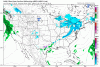
This precip map looks good. All I saw for our area.No Euro snow maps from last night? Must have been pretty bad.

Kbmx says 1-2 inches. Awesome writeup by Matt, extremely detailed .Wish he would find his way to the boardFFC says meh maybe a dusting in the mountains.

No doubt. I think 1-2" is a possibility for y'all and us at this point. Almost to Nam range as wellKbmx says 1-2 inches. Awesome writeup by Matt, extremely detailed .Wish he would find his way to the board
Sent from my SM-J320VPP using Tapatalk
Ya, for sure for y'all, but euro wasn't a whole lot different last night. Maybe a little less qpfThose totals include precipitation from last night so it is significantly overdone.
Looking at the city charts 3-6 across wake countyThis precip map looks good. All I saw for our area.

HUN says not expecting over an inch after going into how it may be moderate and ratios very high, etc. Playing it very conservative.Kbmx says 1-2 inches. Awesome writeup by Matt, extremely detailed .Wish he would find his way to the board
Sent from my SM-J320VPP using Tapatalk
Yea the 6z 12k NAM increased moisture back West over TN and Northern MS from 0Z run.No doubt. I think 1-2" is a possibility for y'all and us at this point. Almost to Nam range as well
I agree it's an all or nothing thing again. This could be flurries at best to maybe an inch or 2 for most outside of y'all's area. Maybe more there. 1 of the local Mets here, was like it's irresponsible to talk about snow right now. I'm like ya ok, it's 3.5 days away, you shouldn't over play it at all, but saying it's not possible is much more "irresponsible" imhoAgreed, only very slightly. Actually beefed up snow at RDU but was drier further west. That would not surprise me based on clipper climo for the sweet spot to end up somewhere from GSO to RDU corridor or slightly east.
1-2 Seems resonable. This won't be a big snow but it could have big impactsHUN says not expecting over an inch after going into how it may be moderate and ratios very high, etc. Playing it very conservative.

And then it turned out to be not much of anything for Wake.Amen brother, amen! I really respect that and commend you for that attitude! Folks are not dumb - if you present them with the scenario in an intelligent manner, most can comprehend that it's a possibility and to keep an eye on the forecast. All of these "our worst case scenarios are coming true" silliness at the 11th hour is just embarrassing, and that just happened here with the NWS-RAH for our last event.
NWS-RAH and the local broadcasts coverage area includes plenty of folks west of Wake County where they were consistently told that they would receive little to no accumulating snowfall. Yet Chatham, Lee etc. received 4 to 6". Imagine being an elderly person who had made their medical appointment plans or plans to pickup their medication the next day based on the consistent forecasts stating no snowfall if you lived in that area. It's rubbish and it's selfishly driven by this idea of it being better to be conservative until the last moment and then ramp up totals because people don't really care if you bust low only if you bust high. I think it's a deplorable practice.
That should come stamped on every ECMWF/EPS output generated. 100% agree on everything stated here. I'm not saying this in a condescending way, but I highly doubt that more than 1 or 2 folks at NWS-RAH have ever heard of the RGEM (unless someone has made them aware of it). When I was there, many did not even know the CMC was in AWIPS and you'll notice they never mention it or other models like the UKMET.
Matt Grantham at BMX is awesome!!! I highly respect his disco/forecasts.FROM KBMX - what storm referenced
Models have held fairly steady with the upper-level pattern for
Tuesday as an Arctic vortex moves southward over the Great Lakes
Region. This will drive an Arctic front southward, and concern is
growing regarding the potential for snow just behind the front.
Southerly low-level winds over the western Gulf of Mexico will
guide moisture northward toward the ArkLaTex where it will become
lifted as height falls overspread the region. The combination of
lift from the right entrance region of a 300mb jet and a
developing 850mb trough along a thermal gradient, will be crucial
in this situation. Models will need more time to resolve these
features and come to a consensus on the amount of expected
precipitation. Currently there is good operational and ensemble
support for 0.05-0.10 inch QPF across most or perhaps all of the
forecast area Tuesday into Tuesday night. Temperature profiles
suggest this will fall almost exclusively as snow, even in our
southern areas with temperatures in the 22-30F range. This could
yield snow ratios up to 18:1 especially across the North, which
means 1-2 inches could of snow could occur from just 0.10 inch of
liquid equivalent. This is a challenging forecast because we are
only talking about a minimal amount of liquid equivalent amounts,
but temperatures will be more than cold enough for significant
impacts to roadways. Slight changes meteorological features could
mean the difference between no precipitation and a high-impact
event.
Looks as though this NAM run will be an improvement on the last for TN, AL, GA, MS. the wave crashing into the PAC NW is slower and ridging is further west. Should help the northern stream dig a bit more. Hope that is a trend we see on all the models today.

AgreedMatt Grantham at BMX is awesome!!! I highly respect his disco/forecasts.
1-2 Seems resonable. This won't be a big snow but it could have big impacts
Sent from my SM-J320VPP using Tapatalk
Agree.... this will need to be an "Impact base" forecast rather than the "normal" guidelines for advisories/warning etc.Bingo!! And that's why you have to pay super attentive on this. Even an inch of snow is gonna stick like glue.
Thank you! When I was on TV, I know y'all know from being on the board here and FB, because most on here are not from Macon DMA, know I always made my own forecasts. I'm talking about maps of events (good or bad lol) but I owned them. nWS is awesome and great folks, seriously. However, can't tell you how many times there forecasts get barfed back out over the airways. This isn't a rant and sorry if it sounds like it, but it always bothered me how conservative and scarred people are to make there own forecast and maps and to tell people about the potential. That's your job!! This will not be a huge snowfall, hell if any, BUT it could have HUGE impact. It almost reminds me of a snow jam 2014 setup ( maybe not as much precip) but Arctic airmass incoming and shi* is gonna stick like glueAmen brother, amen! I really respect that and commend you for that attitude! Folks are not dumb - if you present them with the scenario in an intelligent manner, most can comprehend that it's a possibility and to keep an eye on the forecast. All of these "our worst case scenarios are coming true" silliness at the 11th hour is just embarrassing, and that just happened here with the NWS-RAH for our last event.
Everyone needs to remember that the NAM and moisture go together like chocolate and gum. You think it's a good idea, but it's just nasty in the end!