NCHighCountryWX
Member
- Joined
- Dec 28, 2016
- Messages
- 700
- Reaction score
- 1,921
GSP has already removed accumulating snow from a lot of the grids. Pray your Rosary tonight for sleet and not freezing rain.

I’ve learned over the years to look at soundings as opposed to that 540 line. They just give a more presentationIsnt the 540 line all the way to DC on that? Pretty much takes all the snow out of VA if so.
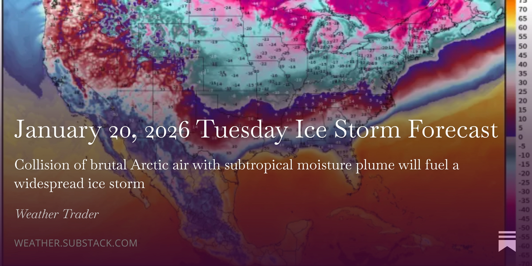
very sharp gradient between Atlanta and Newman if this is correct.View attachment 186619IMO the 18Z Euro is the worst case scenario. It's ZR depiction is a legit ZR look. The 850's are roasting, the 700's are warm, and the 925's are not nearly as cold. This FRAM estimate is scary. The surface temps are still in the mid to upper 20's across the upstate even with it's unrealistic surface depiction of driving the surface low too far north. 0.75"-1" accrual would absolutely be legit here in the upstate.
LOL. Would be interesting to know what model. I have been personally following the EURO closely since Sunday. The 18Z run was awful. Going to see how this all unfolds.TWC says they are using a hybrid model and have two feet possible into Mississippi View attachment 186610
Last thing I'll say (I think). I said yesterday that we will be making our biggest adjustments to this one over the next 8 to 10 model cycles, so into tomorrow night. The window for wholesale changes is short, but again, as I've said, the tiny changes inside D4 can make big differences for folks near the transition lines. If you want to get this thing much further south, tomorrow is probably the day to get it done.This trend is absolutely occurring and is bad news for ice moving further north than anticipated. We always knew there would be ice. We always knew there would be ptype questions for NC.
Is this something that can reverse? Seems like it could, given quality/quantity of obs increases soon. Could keep going and going and digging and digging too. I am too inexperienced to know and I am not sure experienced folks know.
View attachment 186623
Here's the long-term weathernext2 trend for the same time:
View attachment 186624
Guys we don’t need to focus on one model and one run. This is going to keep changing and won’t be locked in until Thursday. That’s 2 more days!!LOL. Would be interesting to know what model. I have been personally following the EURO closely since Sunday. The 18Z run was awful. Going to see how this all unfolds.
Probably get see that data input from it on the models on 12z tomorrow.
Interesting. I know the dropsonde flights were scheduled for tomorrow for data that would be ingested for the 00z tomorrow night. I had assumed that was gonna be our biggest “accuracy jump” but idk.
I wonder if this new data was ingested in the 18z or will be in 0z or later runs…


Something like this is normal, last weekend was a head scratcherI could be wrong but is it normal to do all these recon flights for winter storms? It’s almost like our models suck and are not getting any updates and this is what we are resorting to.

Ouch. Thats entirely a cold rain for Atlanta.Google AI model has always been one of the more amped models and has the heaviest precip axis well up into northern VA but still temps are well below freezing all weekend for central NC.
One good news is much less precip with more amped. Maybe we get dry slotted.
View attachment 186626View attachment 186627
This trend is absolutely occurring and is bad news for ice moving further north than anticipated. We always knew there would be ice. We always knew there would be ptype questions for NC.
Is this something that can reverse? Seems like it could, given quality/quantity of obs increases soon. Could keep going and going and digging and digging too. I am too inexperienced to know and I am not sure experienced folks know.
View attachment 186623
Here's the long-term weathernext2 trend for the same time:
View attachment 186624
2.15" at Roanoke????In spite of the Euro run, Charlotte gets 2 inches of precip with temperatures below freezing the full storm. Don't know if that's ever happened.
Feb 1969: 1.38
Feb 1979: 1.30
Jan 1988: 1.04
Jan 1996: 1.05
Dec 2002: 1.14
Feb 2004: 0.96
Feb 2014: 1.73
View attachment 186601
At 1pm Saturday as the precip is moving in, Charlotte surface temperature is 25 with a dewpoint of 1 (Greensboro is 20 / -11). Huge winter storm if the damming and cold temperatures hold (I think it will for the most part)
View attachment 186604
View attachment 186605

 )trend is still for a deep traditional Carolina wedge. You can always ride this one out the rest of the way with tour local Met if it all becomes too much to stomach.
I posted this tweet about 3 years ago and I think it's relevant to what you're asking here. This kind of thing can happen when you get giant arctic air masses like this so close to the Rockies.
So what are the implications to this storm

I posted this tweet about 3 years ago and I think it's relevant to what you're asking here. This kind of thing can happen when you get giant arctic air masses like this so close to the Rockies.
It’s great in terms of direct impacts, but it greatly further erodes public trust in the ATL area. Wish we got this right sooner is all.love it
Gun to my head if you ask me how the 00z go I say the low slows or stays put and the Montana shortwave keeps digging and those counterbalance each other and we stay in detente
CAD is one thing that overperforms more times than not.When in doubt, zoom out..AI (
Just hard to trust the NAM after last weekend. It was horrible.This is probably right at the fringe of the range I would consider the NAM's output at all potentially helpful (48-60 hours, tops)
CAD is one thing that overperforms more times than not.
Just out of curiosity, do you think the NAM is useful with H5 features and high pressure locations/strength beyond 60 hours?This is probably right at the fringe of the range I would consider the NAM's output at all potentially helpful (48-60 hours, tops)
not really tbh i'm kinda embarrassed for having it open on weatherbell right now. but again i am newer to this than the others on here so it may have some useJust out of curiosity, do you think the NAM is useful with H5 features and high pressure locations/strength beyond 60 hours?
Fair enough. I’ve always heard differing opinions on it. Some have said to never trust its surface reflection that far out but that the H5 charts can be useful. Others don’t even look at it past 48 hrsnot really tbh i'm kinda embarrassed for having it open on weatherbell right now. but again i am newer to this than the others on here so it may have some use

 open.substack.com