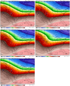
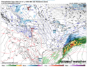
What's the deal with the 6z EPS going north?
-
Hello, please take a minute to check out our awesome content, contributed by the wonderful members of our community. We hope you'll add your own thoughts and opinions by making a free account!
You are using an out of date browser. It may not display this or other websites correctly.
You should upgrade or use an alternative browser.
You should upgrade or use an alternative browser.
Wintry January 23rd-27th 2026
- Thread starter SD
- Start date
From what I’ve read this morning… don’t expect fluffy dendrites with a +1c 700mb layer, lol.
But there are multiple reasons ratios will be better than your standard bb type sleet pellet storm.
1. Partially melted and refrozen flakes will accumulate better than sleet, and we’re going to see lots of that across the area in the transition zones
2. There will probably be some of the rapid water drop freezing/busting that Webber described from time to time. And it’ll potentially be cold enough for some snow-like crystallizations to form on those shattered bits before they reach the ground
But I’d love to hear expert opinions on this. I’ve personally never experienced sleet with a -10-12 cold layer so I’m curious to what see what that looks like.
Last January we mixed with sleet during our coastal storm. Only for like an hour but it was strange with surface temps in the upper teens to around 20. It never turned crusty.
MichaelJ
Member
In the Western Triad, with ground temps at 15-25, the ratio will NOT be 10-1 on snow, maybe more like 12 to15-1. Personally I am not buying those temps at the height of the storm but could see 20-25 degrees which would mean 11 to 12-1 snow ratios. Still 4 days to go folks so keep your hopes in check and take these numbers with a truckload of salt. I am going to start praying for Atlanta today, anywhere near these numbers of ZR will be catastrophic.
Tsappfrog20
Member
View attachment 186229
The NAM showing this thing getting going really early Friday.
The real question is when will they start brining the roads if it looks like it might rain on Friday!
Sent from my iPhone using Tapatalk
rburrel2
Member
You guys had a 900mb warm nose, so that makes sense for that storm.Last January we mixed with sleet during our coastal storm. Only for like an hour but it was strange with surface temps in the upper teens to around 20. It never turned crusty.
We’re dealing with a 700-750mb’ish warm nose with this storm. A whole different animal.
I know been said a thousand times on here but seeing more amped solutions, qpf bombs, but surface remaining just as cold or colder. Couldn't draw up a worse case widespread ice storm imho. Get storm ready now
You guys had a 900mb warm nose, so that makes sense for that storm.
We’re dealing with a 700-750mb’ish warm nose with this storm. A whole different animal.
Ah yea see that on the sounding posted now.
I said this yesterday, and I certainly don't want to be widreman, but I have seen these big, historic cold presses end up being not quite as massive as advertised as we get closer, allowing for the more amped solutions to occur, particularly in the absence of strong blocking. I'm not saying that this has to happen here, but seeing more amped solutions showing up as we get closer, and if we start seeing the show footprint head north through the day, that would be a huge red flag.
TigerSnow
Member
Agreed, we’ve seen the high that is supposed to be super strong weaken as we get closer to game time. Then we end up with a cutter and some cold rain. What we are seeing is biblical stuff. We’ve seen this before and ended up with cold rain. A lot of what we are seeing goes against climatology, especially with how strong the cad is showing.I said this yesterday, and I certainly don't want to be widreman, but I have seen these big, historic cold presses end up being not quite as massive as advertised as we get closer, allowing for the more amped solutions to occur, particularly in the absence of strong blocking. I'm not saying that this has to happen here, but seeing more amped solutions showing up as we get closer, and if we start seeing the show footprint head north through the day, that would be a huge red flag.
That’s a great point. Let’s just assume for arguments sake the High is about 8mb weaker. How far north does this storm need to run to scour out this wedge? I’m trying to find a fire escape. Is there one?I said this yesterday, and I certainly don't want to be widreman, but I have seen these big, historic cold presses end up being not quite as massive as advertised as we get closer, allowing for the more amped solutions to occur, particularly in the absence of strong blocking. I'm not saying that this has to happen here, but seeing more amped solutions showing up as we get closer, and if we start seeing the show footprint head north through the day, that would be a huge red flag.
GoDuke
Member
Stormsfury
Member
Yep, Great Lakes low go poof, and the reemerging of the sprawling high with the NE high building south and strengthening. It's learning folks.
ForsythSnow
Moderator
We need to wait for the Baja low to come in closed to California by Wednesday to know for certain anything. We have our scenarios I believe but with the sensitivity of it, that will determine the positioning of the ptypes.
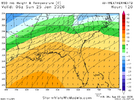
06z WeatherNext took a jump southward with mid-level warmth Saturday night/early Sunday for the Carolinas. Ticking colder at the surface. At this point it is pretty clear the old OPs have a better handle on CAD sig. May need to root for this at this point if you're living around here, could take some of the bite of the ZR potential by starting as snow/sleet and hanging on for longer
New H85 temps:
Old:
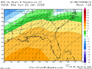
This moved all the ptype corridors south a bit as well, as you'd expect. Getting closer to Euro/GFS look.
New H85 temps:

Old:

This moved all the ptype corridors south a bit as well, as you'd expect. Getting closer to Euro/GFS look.
The problem is no matter what, someone gets screwed with the ice storm. So your good news is our bad news lol06z WeatherNext took a jump southward with mid-level warmth Saturday night/early Sunday for the Carolinas. Ticking colder at the surface. At this point it is pretty clear the old OPs have a better handle on CAD sig. May need to root for this at this point if you're living around here, could take some of the bite of the ZR potential by starting as snow/sleet and hanging on for longer
New H85 temps:
View attachment 186238
Old:
View attachment 186239
This moved all the ptype corridors south a bit as well, as you'd expect. Getting closer to Euro/GFS look.
Yeah, I am trying to be more careful about what is a "good" trend. We've said it for a couple of days now, not sure how an ice storm for someone is avoided.The problem is no matter what, someone gets screwed with the ice storm. So your good news is our bad news lol
ForsythSnow
Moderator
I'd say at this point if it has to be sleet I'd rather most get that than screwed by major icing. The qpf may actually need to downtrend for that to happenYeah, I am trying to be more careful about what is a "good" trend. We've said it for a couple of days now, not sure how an ice storm for someone is avoided.
IMO there will be much more sleet than the Euro would indicate. I wouldn't be shocked if the ZR potential ends up a bit further south than where we wind up expecting it 24 hours outI'd say at this point if it has to be sleet I'd rather most get that than screwed by major icing. The qpf may actually need to downtrend for that to happen
For the record, in regards to our “storm” last Sunday, modeling was overamped by a large scale at this lead. Yes I know, different setup. But those are the facts
NCWeatherhound
Member
Meanwhile, down here in the Sandhills, we're entering uncharted territory. Our usual snow/rain rules don't apply, and it's been tough to convince neighbors to get ready now.
"Oh, you know what's going to happen. It will all just be cold rain."
Cold, definitely. But rain? I feel like Cassandra at the gates of Troy.
We can live with sleet, but the increased interaction with the Baja Low and the GFS warm nose has me even more concerned about the potential for brutal ice accumulations. Power disruption down here could reach hurricane levels. I-95 will be out, as will 40 down to the coast.
wondering something this a.m.
Fact: if a dendrite comes down, crosses the 0 line, fully melts, obviously then, even though it crosses back below 0 line. Its frzng rain, not sleet. Get that. Has to maintain some flake charectiristic, as it crosses back to end up being sleet. Meaning its journey into the warm nose, has to be short lived to end up at the surface as sleet pellet.
But heres my question. All dendrites have to form behind the -10 line on the T gram. So if a dendrite forms, crosses into the warm nose and fully melts, then comes back below freezing and gets behind the -10 line again in the bottom shallow part of the T gram. Will it be a snowflake when it hits the surface, assuming it stayed behind the 0 / freezing line?
See some T grams getting close to double dipping behind the -10 line
iGRXY
Member
Usually that would have started happening by now. The high is trending stronger this time around. Very rareI said this yesterday, and I certainly don't want to be widreman, but I have seen these big, historic cold presses end up being not quite as massive as advertised as we get closer, allowing for the more amped solutions to occur, particularly in the absence of strong blocking. I'm not saying that this has to happen here, but seeing more amped solutions showing up as we get closer, and if we start seeing the show footprint head north through the day, that would be a huge red flag.
Kylo, that hybird GFS lollipop qpf areas, seem to be consistently appearing on other models in N AL and NGA. Right where the biggest Frzng Rain potential exist imo.
Also I'm noticing from Chattanooga into SW NC getting smoked. The old rainforest ( use term loosely) area SW NC may end up with a 3o inch + lollipop of snow. Highlands, Cashiers, definitely the higher peaks. They will maximize and squeeze everything atmosphere has to offer out of this type of setup. I can see a 3.0 qpf up there
Also I'm noticing from Chattanooga into SW NC getting smoked. The old rainforest ( use term loosely) area SW NC may end up with a 3o inch + lollipop of snow. Highlands, Cashiers, definitely the higher peaks. They will maximize and squeeze everything atmosphere has to offer out of this type of setup. I can see a 3.0 qpf up there
UNCSC
Member
If we haven’t learned anything through the past couple years, we have seen a lot less north trends on most storms. If not more southern trends closer to go time
Brandon10
Member
While possible...with the strength of this high and TPV, I dont see how the coastal low turns the corner and goes NE. I see this as a WSW to ENE mover hopefully keeping the snow line further south and west/east oriented.
There is no escape hatch. An historic, at minimum, and potentially catastrophic event for some, is on the way.That’s a great point. Let’s just assume for arguments sake the High is about 8mb weaker. How far north does this storm need to run to scour out this wedge? I’m trying to find a fire escape. Is there one?
I'm just hoping for less ice for everyone.
rburrel2
Member
January 88’ish. That seems to be where we’re heading, imo.Kylo, that hybird GFS lollipop qpf areas, seem to be consistently appearing on other models in N AL and NGA. Right where the biggest Frzng Rain potential exist imo.
Also I'm noticing from Chattanooga into SW NC getting smoked. The old rainforest ( use term loosely) area SW NC may end up with a 3o inch + lollipop of snow. Highlands, Cashiers, definitely the higher peaks. They will maximize and squeeze everything atmosphere has to offer out of this type of setup. I can see a 3.0 qpf up there
A record amount of sleet would be the best case scenario for everyone in the icy columns. With how cold this system is more sleet wouldn’t be something bad to bet onThere is no escape hatch. An historic, at minimum, and potentially catastrophic event for some, is on the way.
I'm just hoping for less ice for everyone.
Cary_Snow95
Member
Just going to leave this here
NEGaweather
Member
Just going to leave this here
Are they literally posting the damn CMC? That’s definitely an idea
Sent from my iPhone using Tapatalk
Yes.
there's no way this is helpful. to clarify the longwave patterns determine where the high is and if the the longwave pattern nudges northwest, which can and does happen, everything will follow suite. both things can be true that modeling may not render what a strong high does correctly (would cause suppression bias) and also they could be wholly too far south with the synoptic features (amp bias)No
Sent from my iPhone using Tapatalk
Was about to say did they pick the worst possible map to tweetAre they literally posting the damn CMC? That’s definitely an idea
Sent from my iPhone using Tapatalk
This is true. The ice accrual totals do not include the precipitation that falls off of objects before it freezes. I usually cut model totals by one half whenever I look at potential freezing rain totals. With the strong CAD in place, there will not be much latent heat release from objects so what falls will have a greater chance of sticking which means that the ice totals being forecasted will still be crippling at one half of these totals.
Not trying to call anyone out but just to give an example of how we try to moderate and why. I just deleted 2 post, one said yes and one said no to the same question. If you are going to respond to questions, 1 word answers aren't gonna cut it. There has to be some reasoning for your response and clarification. Lot of new people on this site, trying to figure out what's gonna happen and to learn, those responses don't do it. Thanks
ducketta27
Member
This is true. The ice accrual totals do not include the precipitation that falls off of objects before it freezes. I usually cut model totals by one half whenever I look at potential freezing rain totals. With the strong CAD in place, there will not be much latent heat release from objects so what falls will have a greater chance of sticking which means that the ice totals being forecasted will still be crippling at one half of these totals.
Another thing to note is that the latent heat release will be even more limited given the wind gusts during the storm
Sent from my iPhone using Tapatalk

