-
Hello, please take a minute to check out our awesome content, contributed by the wonderful members of our community. We hope you'll add your own thoughts and opinions by making a free account!
You are using an out of date browser. It may not display this or other websites correctly.
You should upgrade or use an alternative browser.
You should upgrade or use an alternative browser.
Wintry January 23rd-27th 2026
- Thread starter SD
- Start date

Chattownsnow
Member
I’m just referring to the ai models really. Just keeps moving southThe latest GFS gives DC a foot.

iGRXY
Member
UK absorbed it and it’s very amped
a little more backloaded than the 12z, maybe slightly more amped but nothing wild
rburrel2
Member
Wedge trends on the gfs ai… lol.

Ugh. Should have went to bed

VegasEagle
Member
Snowflowxxl
Member
UKMET has looked like this the entire time.
Feels like moves closer to a consensus. Precip onset in the mid south/MS valley is under 100 hours out. GFS and Euro very similar at H5 right now, which probably means the euro will show a completely different solution at 0z just to give us a headache.
Still looks like a big time CAD mess to me locally.
Still looks like a big time CAD mess to me locally.
Yup, and getting much colder at 2m from prior runs, just like the Icon.Writing is on the wall. This baby is amping up.
View attachment 186077
00z

12z

wow
Member
UKMET unchanged from the 12z run pretty much
iGRXY
Member
UK doesn’t handle the BL temps well at all. Even the CMC which absorbs the Baja low is in line from a surface standpoint. UK is an outlier to me
got 2m temp trend?
iGRXY
Member
Not really it’s surface depiction is not accurateAgreed. Impressive how it's been leading the way right under our noses and now everything shifting to it!
JP152
Member
GFS trended North.Ahhh yes the trusty UKMET. Nevermind the other 4-5 models that have this thing southern bound
Sent from my iPhone using Tapatalk
ukmet has severe in augusta and ice in charlotte. which, ok. but personally i don't think the wedge will act like that
Correct. Not sweating it. Canadian has looked like garbage every run since onset as well. Euro familia can hold tight tonight we all still good.UKMET has looked like this the entire time.
iGRXY
Member
got 2m temp trend?

The trend is in fellas. Players are on the field and the fly has landed in the ointment. The Baja wave is probably coming. Make it work anyway
Pilotwx
Member
Ratios will be higher than 10:1
no, not really. the precip field just expanded quite a bitGFS trended North.
We’re really close to having an upper echelon event, but it sure looks like it’s going to be mighty tough to get this to stay suppressed in the Jan ‘88 mold. Hoping for bigger trends south next couple days, but not counting on it. Regardless, I’ll take a big nasty mixer in the face if I have to
NBAcentel
Member
Something to watch is if we keep slowing, and slowing, you allow cold and dry air to seep in at all levels, and your initially slamming WAA/precip into confluence. Starting to get that front end thumper/finger look 
rburrel2
Member
got 2m temp trend?

I am in south central Alabama and we haven’t had measurable snow in YEARS. That’s what I mean by Deep South lol not the gulf coast.
We had 3” in Birmingham last year but yea it’s still been too long
Sent from my iPhone using Tapatalk
QPF trend will be interesting to watch. I tend to think it could be a bit overdone at the moment in general but like I said earlier, anomalous gradient. Also, the sleet monster can eat those big GEFS totals for brunch.
TigerSnow
Member
Is it possible that we trend into a cold rain in most places? Is this a normal setup where we can have too much WAA and we lose it altogether?We’re really close to have an upper echelon event, but it sure looks like it’s going to be mighty tough to get this to stay suppressed in the Jan ‘88 mold. Hoping for bigger trends south next couple days, but not counting on it. Regardless, I’ll take a big nasty mixer in the face if I have to
LukeBarrette
im north of 90% of people on here so yeah
Meteorology Student
Member
2024 Supporter
2017-2023 Supporter
Please nobody in here throw the towel because the UKMET and Canadian said cutter. Just two awful models guys cmon
JWaterman
Member
Is it possible that we trend into a cold rain in most places? Is this a normal setup where we can have too much WAA and we lose it altogether?
Absolutely not. Everything will either be snow, ice or sleet. Unless you’re in deep deep GA/AL.
Sent from my iPhone using Tapatalk
I'm with you 100%. But i admit ive gotten greedy with this one. 2 things we dont have to fight is surface temps and qpf. Slam dunk wins. Its that mid level hangnail, thats gonna throw shade at us, up till last second.We’re really close to have an upper echelon event, but it sure looks like it’s going to be mighty tough to get this to stay suppressed in the Jan ‘88 mold. Hoping for bigger trends south next couple days, but not counting on it. Regardless, I’ll take a big nasty mixer in the face if I have to
Foot plus is right there for the taking.
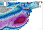
GEFS trend
View attachment 186085
View attachment 186090and still going........
The majority of this 0Z Pivotal GEFS “snowfall” in much of N GA/SC except far N is IP or ZR. Here’s one panel to show that:

Last edited:
I highly doubt that unless the timing is way off with the surface high moving in - like the surface high trends way slower and the Baja low kicks out way quicker. Unlikely IMOIs it possible that we trend into a cold rain in most places? Is this a normal setup where we can have too much WAA and we lose it altogether?
Edward Nygma
Member
The UKMET is not an awful model, especially not at 500mb, which is what ultimately is driving this event.Please nobody in here throw the towel because the UKMET and Canadian said cutter. Just two awful models guys cmon
LukeBarrette
im north of 90% of people on here so yeah
Meteorology Student
Member
2024 Supporter
2017-2023 Supporter
Yeah I don’t want to see the pivotal weather GEFS maps ever again. They include sleet.The majority of this 0Z GEFS “snowfall” in much of N GA/SC except far N is IP or ZR. Here’s one panel to show that:
View attachment 186100
Weatherbell or COD Meteorology from now on, thanks!

So pretending this cuts and OH gets 12in SN. You mean to tell me Augusta and BHAM are still getting ice?Absolutely not. Everything will either be snow, ice or sleet. Unless you’re in deep deep GA/AL.
Sent from my iPhone using Tapatalk
I'm sure the Mid Atlantic and NE weenies are throwing a party tonight. Here in squitter land, we toss.

JWaterman
Member
So pretending this cuts and OH gets 12in SN. You mean to tell me Augusta and BHAM are still getting ice?
I’m more so going based on current (reliable) model trends. We all know anything is possible in extreme scenarios one way or another.
Sent from my iPhone using Tapatalk
Yeah I don’t want to see the pivotal weather GEFS maps ever again. They include sleet.
Weatherbell or COD Meteorology from now on, thanks!View attachment 186101
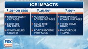
The graphics that were shown by Brady were positive depth changes, which is supposed to be used to indicate general wintry precipitation.
Use Total Snowfall (10:1/Kuchera) if possible. They're the same as WeatherBell's.