This experimental nowcasting model seems convinced that there will be at least some precip (dbz>0) in ATL in about 4 hours.

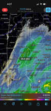
Interesting that it models a 50% chance of measurable precipitation as far west as Birmingham.This experimental nowcasting model seems convinced that there will be at least some precip (dbz>0) in ATL in about 4 hours.
View attachment 184880
Yeah I'm not sure how accurate this is, exactly. It is an experimental project that I am working on and hasn't been tested enough yet. So take it as a grain of salt. One thing I will mention, however: this is probability of >0dbz, so not necessarily measurable QPF/precip.Interesting that it models a 50% chance of measurable precipitation as far west as Birmingham.

Any recent or upcoming radiosonde data that you may be privy to? Here, midway between Atlanta and Athens, I'm feeling more confident regarding perhaps overperforming to perhaps .10-.20 in the bucket, but the delayed cold, which so often happens out this way, bugs me.Yeah I'm not sure how accurate this is, exactly. It is an experimental project that I am working on and hasn't been tested enough yet. So take it as a grain of salt. One thing I will mention, however: this is probability of >0dbz, so not necessarily measurable QPF/precip.
Its amazing that I am not far from you and you are at 40/38 and I am at 39/27. Wow!Any recent or upcoming radiosonde data that you may be privy to? Here, midway between Atlanta and Athens, I'm feeling more confident regarding perhaps overperforming to perhaps .10-.20 in the bucket, but the delayed cold, which so often happens out this way, bugs me.
Man, some years back we were under a heavy snow warning, and I called home to my wife while working in Snellvile where about 3 inches had fallen, to ask her what it looked like, and we had zilch at the house. CAA is always delayed here.Its amazing that I am not far from you and you are at 40/38 and I am at 39/27. Wow!
Nah, no radiosonde data.. but looking at a combo of GOES data, radar data in SW AL/SE MS, and observation stations across the area, I'm still not buying any accumulating snow in ATL and probably little-to-none in Between, GA. Even in Mobile, AL, the precip isn't really close to reaching the surface (evaporating at around 1000 ft above the ground). Low levels are supremely dry, so even with additional moisture advecting in aloft, it will take a LOT of virga before we actually see any precipitation reach the surface.Any recent or upcoming radiosonde data that you may be privy to? Here, midway between Atlanta and Athens, I'm feeling more confident regarding perhaps overperforming to perhaps .10-.20 in the bucket, but the delayed cold, which so often happens out this way, bugs me.


Thanks! I really appreciate it. Here's to hoping the radar begins to fill in hard to the west.Nah, no radiosonde data.. but looking at a combo of GOES data, radar data in SW AL/SE MS, and observation stations across the area, I'm still not buying any accumulating snow in ATL and probably little-to-none in Between, GA. Even in Mobile, AL, the precip isn't really close to reaching the surface (evaporating at around 1000 ft above the ground). Low levels are supremely dry, so even with additional moisture advecting in aloft, it will take a LOT of virga before we actually see any precipitation reach the surface.
View attachment 184882
I truly wish I had a more favorable forecast. There are few things I love more than snow, so this event has been a bummer.Thanks! I really appreciate it. Here's to hoping the radar begins to fill in hard to the west.


Looks like the precip is getting closer to the radar beam in Montgomery ALAs nice as the composite radar looks, there is much work to do to get something to the ground. Virga galore.
Dang. Every CAM lessened snow totals over middle Georgia overnight. Was about to hit the road and head that way but reconsidering if it’s worth it now
It won't be very long before the back edge of the pass by here. I estimate I have a brief window between 6-8 AM to see a few non-accumulating flakes fly. Sigh.Looks like the precip is getting closer to the radar beam in Montgomery AL
Honestly after all this I would consider some snowflakes a win. But, the chance is fading fast… need some saturation to happen quickIt won't be very long before the back edge of the pass by here. I estimate I have a brief window between 6-8 AM to see a few non-accumulating flakes fly. Sigh.
Yep. There is nowhere under the returns of interest to us in N. Ga near saturation at the surface, even down to Montgomery. That doesn't mean we can't see some flakes flying shortly, but accumulations are off the table IMO.Honestly after all this I would consider some snowflakes a win. But, the chance is fading fast… need some saturation to happen quick

I'm up for a few minutes to see if we can get anything through the dry layers. Looks like snow is "disappearing" at around 9,000 ft per the KFFC radar. That matches closely with the RAP sounding at 5 am. A new mPing for snow just appeared in Rome, GA but I think it's probably false.Yep. There is nowhere under the returns of interest to us in N. Ga near saturation at the surface, even down to Montgomery. That doesn't mean we can't see some flakes flying shortly, but accumulations are off the table IMO.

Thank you for this link! That's fun to watch. No snow falling here. 35.8/22.4.Toomers Corner - City of Auburn
www.auburnal.gov
Flakes flying in Auburn per Toomer’s corner live cam.
Cars are leaving tracks in the snow! People are already out in it! Cool!Toomers Corner - City of Auburn
www.auburnal.gov
Flakes flying in Auburn per Toomer’s corner live cam.
Euro says you get yours from 6:30-9:30. No reason to panic yet.Nothing here yet. I should remain under decent radar returns for another hour or so, so we'll see if I can spot a rogue flake or two.
Yep...precip is only 700 feet up and droppingPeachtree base radar is getting mighty close to the ground. We might have something around town soon.
Bone dry here..tee off at 730auburn snow at 6am tells me hrrr and rap are too agressive with drying up the upper level precip. The 00z euro is verifying perfectly though on precip. Expect some snow in to Atlanta, Athens, and GSP.
And so it begins!I am staring into a streetlight and can barely see tiny flakes coming down that are so small I needed to cover the light to see them. I am about 20 miles north of Atlanta