LukeBarrette
im north of 90% of people on here so yeah
Meteorology Student
Member
2024 Supporter
2017-2023 Supporter
You can’t see a flip to snow as the surface low pulls away? I don’t think that’s out of the question. 1-2 hours of wet snow for central NC
I’ve never had an event be all rain with literally every model, globals and NAMs, showing snow. Maybe it won’t accumulate but that would be a first for to be all rain.
Rookie. Happens to me all the time.I’ve never had an event be all rain with literally every model, globals and NAMs, showing snow. Maybe it won’t accumulate but that would be a first for to be all rain.
Southern GA has dry air aloft issues, but there is potential that it is overcome in about a 20 mile wide swath centered somewhere around Albany, GA.That's not what he's been saying. He's been talking about NC and sc having issues
Sounds good to me..has me between 0.30 to 0.40...lol. Interesting that both models have greatly increased totals over central ga and sc though.
View attachment 184577

Jan 2017 the NAMs were showing sleet storm where globals were showing snow. We got a raging sleet storm. I remember that vividly.I have a hard time seeing it in Raleigh with how this is setup
Jan 2017 says hi
Jan 2017 the NAMs were showing sleet storm where globals were showing snow. We got a raging sleet storm. I remember that vividly.
This would be a first for nearly every model to be wrong within 24 hours and we see nothing but rain. But…if I had money I would bet on you being right. You’ve had some great calls over the years.
I have a hard time seeing it in Raleigh with how this is setup
Jan 2017 says hi
Yeah, I would think that if the moisture is there that around your area and west towards me there will be snow falling for a few hours that never really accumulates more than a dusting or so. Snow TV and White Rain. I’m here for it though.I’ve never had an event be all rain with literally every model, globals and NAMs, showing snow. Maybe it won’t accumulate but that would be a first for to be all rain.
Yes. I've been looking at the 12KM for days now and should have known to lean on the 3KM this close in.When looking at the NAM go with the higher resolution 3KM rather than the12KM as far as track is concerned. Don't think either one is correctly identifying where the frozen precip or the amount that will actually verify.
I legit have no clue what dry air you are speaking of over central and south ga. North ga, north of Atlanta to athens....sure but south of there its saturatedSouthern GA has dry air aloft issues, but there is potential that it is overcome in about a 20 mile wide swath centered somewhere around Albany, GA.
It is ridiculous. The back edge will be very sharp so there is going to be some heart break.This is a ridiculous hard forecast for ga/sc/nc. That low level dry air punch is concerning for Georgia. No idea how realistic that is or what wins the battle between the low level dry air pushing in and the excellent forcing above it.
NC has boundary layer issues for the whole storm that models are all over the place with.
SC has a mix of both issues.
Amazing how topography works. The green and gray precip line is riding perfectly where the change in elevation quickly increases. That lightest green shade is exactly where you typically see the transition line between frozen and liquid for snow along 85.Ive been worried about that too but now im in the 0.25 range in general . Gfs even showing amounts above 0.30 just south of atlanta. The question is will this trend continue, stop, or back off. If we get another couple of ticks till showtime even areas up to 85 will be doing surprisingly well compared to where we looked a day ago thats for sure.
View attachment 184555
Jan 2017 the NAMs were showing sleet storm where globals were showing snow. We got a raging sleet storm. I remember that vividly.
This would be a first for nearly every model to be wrong within 24 hours and we see nothing but rain. But…if I had money I would bet on you being right. You’ve had some great calls over the years.
Uh ok. Whatever you say. Maybe it only sleeted at my house.Uhh no I’m not, I was literally in downtown Raleigh for that event chief and I know what I saw. It was cold rain mixed with some sleet.
There’s always significant differences between S and N Raleigh, E and W.Uh ok. Whatever you say. Maybe it only sleeted at my house.
Uh ok. Whatever you say. Maybe it only sleeted at my house.
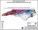
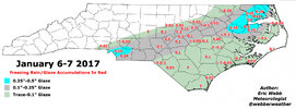
What are we arguing about? I said show me a time where the globals and NAMs were showing snow for central NC at 24 hours out and we got all rain. Jan 2017 isn’t it. Clearly central NC had accumulating snow, this is from your website. You are such a child sometimes. Let it go…you lost this discussion. It happens.We saw a dusting of sleet with mostly cold rain at nc state. Stop

What are we arguing about? I said show me a time where the globals and NAMs were showing snow for central NC at 24 hours out and we got all rain. Jan 2017 isn’t it. Clearly central NC had accumulating snow, this is from your website. You are such a child sometimes. Let it go…you lost this discussion. It happens.
And I agreed with you…you will probably be right about tomorrow. I pay you a compliment and you act like this.
View attachment 184589
Warm bubble. Charleston has warmed up from 33 to 47 from 8am to 9am. (Forecast to reach the low to even mid 60s today). Possible "mesolow" kink in the Midlands, doubling down on cold air delay and thermal cold crash. Moisture and cold will have to arrive quicker or pretty much won't have time to change over.Looks like eastern SC near the coast may only get cold rain right now it seems. I hope I’m wrong though.
Sent from my iPhone using Tapatalk
Guidance has been insistent and it's a combo of absolute perfect timing for that region.Becoming really apparent now that central and south ga are going to get a legit major snowfall
View attachment 184588
Warm bubble. Charleston has warmed up from 33 to 47 from 8am to 9am. (Forecast to reach the low to even mid 60s today). Possible "mesolow" kink in the Midlands, doubling down on cold air delay and thermal cold crash. Moisture and cold will have to arrive quicker or pretty much won't have time to change over.
I loved that storm. Got over 4” of sleet. But I’m 20 miles north of Raleigh.We saw a dusting of sleet with mostly cold rain at nc state. Stop
Seeing this map living 5 minutes from Athens pains me very very close to the green edgeBecoming really apparent now that central and south ga are going to get a legit major snowfall
View attachment 184588
What are we arguing about? I said show me a time where the globals and NAMs were showing snow for central NC at 24 hours out and we got all rain. Jan 2017 isn’t it. Clearly central NC had accumulating snow, this is from your website. You are such a child sometimes. Let it go…you lost this discussion. It happens.
And I agreed with you…you will probably be right about tomorrow. I pay you a compliment and you act like this.
View attachment 184589

