LongRanger
Member
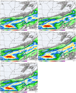
How long before the Euro caves to GFS with the NW trend
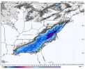
If I remember correctly, the models were dry for the Atlanta and Athens areas right up until the day before the Gulf Coast blizzard. I wound up with about an inch where every flake that fell stuck, and was happy not have been shut out. This was the storm the CMC insisted was going to be historic for N Ga. for days before caving.View attachment 183385
Final total map of GA 1/21 for that storm for comparison. It was too far NW with the northern edge of precip, dry air was too much if I remember correctly
I live near the upper portions of the precip last year, the flakes were small and wispy. Still managed to get 2 in, but it did not last long
View attachment 183385
Final total map of GA 1/21 for that storm for comparison. It was too far NW with the northern edge of precip, dry air was too much if I remember correctly

I was about as far as you could go north before the snow tapered off. Flurries for about 5 minutes and gone.I live near the upper portions of the precip last year, the flakes were small and wispy. Still managed to get 2 in, but it did not last long
View attachment 183385
Final total map of GA 1/21 for that storm for comparison. It was too far NW with the northern edge of precip, dry air was too much if I remember correctly

Tomorrow 12z run...How long before the Euro caves to GFS with the NW trend
I was so excited by the 12z run of the GFS on Jan 21 which brought the 1+ inch totals north of the city after being very concerned about the wrong side of the cutoff, and when the storm happened, I saw about 10 minutes of light flurries and nothing more. It really did crush my spirits too because we had been north of the extremely heavy snow band of the previous Jan 10th snow event, only ending up with just over 1 inch, although I am thankful that it at least broke the 1 inch drought of 5 years.If I remember correctly, the models were dry for the Atlanta and Athens areas right up until the day before the Gulf Coast blizzard. I wound up with about an inch where every flake that fell stuck, and was happy not have been shut out. This was the storm the CMC insisted was going to be historic for N Ga. for days before caving.
Really the main difference on euro is just the tilt. Chances are the tilt is going to not be positive if it phases off the coast of lousiana/texas. Not this can't be an issue.Tomorrow 12z run...
That airmass kept trending stronger and stronger. It was very atypical from what I remember. It was underestimated by every model.Can anyone explain why last years coastal storm did not NW trend while most storms in the past have NW trend?
The costal storm developed had a NW trend. Brought snow well north of expected.Can anyone explain why last years coastal storm did not NW trend while most storms in the past have NW trend?
Completely different airmass from that event to this one.Day 3 out last year for the 1/21 event the Euro was clocking central NC and was too far west. And of course we remember all those super bombs that the CMC kept spitting out which was dead wrong. It's why I like seeing these weaker model runs at day 4, not get our hopes crushed like last year.
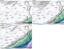
And the Euro AI was east/supressed at this range for last years event.
View attachment 183379
View attachment 183380
Yep...but that the point of that post. Just that the AI model wasn't good and was supressed at day 3-4.Completely different airmass from that event to this one.
The costal storm developed had a NW trend. Brought snow well north of expected.


Absolutely LOVE where the EURO is right now….the king of over-suppression!Still quiet the spread, which just further shows there is a lot to sort out here.
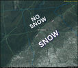
Yep. In Atlanta we basically had a sharp SW->NE cutoff of the snow line. The SE parts of the city ended up getting snow and everything NW of a line got nothing. Really, until the moment of, we had no idea if we'd actually get anything or not.
I remember Apple Weather showed a 0% chance of any precipitation/snow that day, but school was canceled because FFC said there was still a minor chance we'd get snow. There was a big Facebook thread in our school system's parent FB group where folks were so upset they canceled school for a "0% chance!". They had to eat their words the next day when we got snow mid-day that would have caused a major problem for the busses.
The traffic map from that day was crazy.
View attachment 183392
on Twitter he added "The Reliable" EURO A.I.... look, I get verification scores ect but my god, enough with the glazing of the EURO. Like if its that much better just get rid of the other suites, apparently no one looks at them or cares what they say anyway so why even run them. The issue that makes it annoying though is if roles were reversed and EURO was showing an amped stormy solution they wouldnt post it and then theyd hug the gfs. It is the double standard for me
I think it's best we just see little steps in the right direction and not jump the gun like the GFS did.Absolutely LOVE where the EURO is right now….the king of over-suppression!
Can anyone explain why last years coastal storm did not NW trend while most storms in the past have NW trend?

that was a painful eternity watching the big hole on radar fill in.Yep. In Atlanta we basically had a sharp SW->NE cutoff of the snow line. The SE parts of the city ended up getting snow and everything NW of a line got nothing. Really, until the moment of, we had no idea if we'd actually get anything or not.
I remember Apple Weather showed a 0% chance of any precipitation/snow that day, but school was canceled because FFC said there was still a minor chance we'd get snow. There was a big Facebook thread in our school system's parent FB group where folks were so upset they canceled school for a "0% chance!". They had to eat their words the next day when we got snow mid-day that would have caused a major problem for the busses.
The traffic map from that day was crazy.
View attachment 183392View attachment 183397
Last year the airmass was ridicously cold...why it snowed a foot down in New Orleans to the panhandle.
View attachment 183394
He does this every single year. In his defense, a tornado could be deadly where as snow, not so much. I assume that is why he hypes severe weather and not snow. Either way it’s annoying. Like just be real.James Spann needs to quit speaking in absolutes. It’s unprofessional and is how you end up with 2014 on rare occasions. If it was a tornado outbreak he would not use that language
I haven't seen any data or comments on how the ai models handle marginal temps situations or dynamically or evaporational cooling. I wouldn't trust any precip type outputs until we have solid data to base it on. Hopefully we will learn something with this oneWe have had this convo. AI models perform too warm on the surface
