Also west side of tenneseee is snow also.
-
Hello, please take a minute to check out our awesome content, contributed by the wonderful members of our community. We hope you'll add your own thoughts and opinions by making a free account!
You are using an out of date browser. It may not display this or other websites correctly.
You should upgrade or use an alternative browser.
You should upgrade or use an alternative browser.
Wintry Midsouth Winter Storm January 12th-13th
- Thread starter Storm5
- Start date
Big winter storm for north Alabama and Tennessee at hour 90.

Sent from my iPhone using Tapatalk

Sent from my iPhone using Tapatalk

Sent from my iPhone using Tapatalk
DadOfJax
Member
Need a little southward trend to get much of AL in any of the heavy stuff....maybe extreme NW AL right now looks good for potential moderate snow....good trend for the Euro though.

Sent from my iPhone using Tapatalk
That’s a nice 2-4 snow for most of north alabama. Especially west of Interstate 65.Need a little southward trend to get much of AL in any of the heavy stuff....maybe extreme NW AL right now looks good for potential moderate snow....good trend for the Euro though.
Stormlover
Member
What does this have to do with the 12th/13th threat?Breaking; 5 dead in California as strong storm system has forced thousands from their homes due to flooding, mudslides
SCweather
Member
That backside snow will come down fast and furious.
Stormlover
Member

RollTide18
Member

Sent from my iPhone using Tapatalk
Euro has flurries down my way, hope its not too dry this time lol
So i notice it shows ice way up in Ohio. Seems like it would be unusual to have ice that far north and then snow to the south in Alabama.
Storm5
Member
.

Sent from my SM-J320VPP using Tapatalk

Sent from my SM-J320VPP using Tapatalk
If this thing keeps trending to the SE, we will be in business. Regardless, those to our NW gonna get pounded
Storm5
Member
Gfs is the only model that never really close off
12z ero


Sent from my SM-J320VPP using Tapatalk
12z ero


Sent from my SM-J320VPP using Tapatalk
NWMSGuy
Member
So is it NAM/EURO/CMC against GFS now?
I remember the ULL in March of 09 that just kept trending better and better for us in the days leading up. Maybe this one will do the same!
Would that be a better storm for us if it would have closed off??Gfs is the only model that never really close off
12z ero
Sent from my SM-J320VPP using Tapatalk
RollTide18
Member
I remember the ULL in March of 09 that just kept trending better and better for us in the days leading up. Maybe this one will do the same!
How did the ULL move in 2009? Wasn't it SE for a time?
DadOfJax
Member
It has to close off for there to be any cold air to work with. If it doesn't, its just cold chasing moisture setup.Would that be a better storm for us if it would have closed off??
Usmeagle2005
Member
Still going with the GFS to be safe, anything else will be a win.
Any more SE trends and I get a wraparound flurry or two! Just an appetizer for next weeks Tuesday storm. It's a short outbreak of cold , but still potent! I could see supression being an issue, but glad to have euro on board!
JLL1973
Member
not good with me being in the bullseye 4 days out, lol
Xtreme Weather
Member
Interesting to see this trending little farther E at 500mb on the EURO I will say that... Watching
... Carry on
Sent from my iPhone using Tapatalk
... Carry on
Sent from my iPhone using Tapatalk
uncheelfan
Member
- Joined
- Jan 6, 2017
- Messages
- 19
- Reaction score
- 18
Is there any chance this storm can drop down further south and round the east side of the Appalachian Mountains?
Sent from my SCH-I535PP using Tapatalk
Sent from my SCH-I535PP using Tapatalk
Usmeagle2005
Member
I agree, you and me both are, lolnot good with me being in the bullseye 4 days out, lol
I don't think so. All the cold air is west of the apps during this time frameIs there any chance this storm can drop down further south and round the east side of the Appalachian Mountains?
Sent from my SCH-I535PP using Tapatalk
uncheelfan
Member
- Joined
- Jan 6, 2017
- Messages
- 19
- Reaction score
- 18
Good trends today on most of the models for this storm. Im in east Tennessee and havent had squat so far this year except a dusting. Im jonesing bad for some accumulating snowfall!!!!
Sent from my SCH-I535PP using Tapatalk
Sent from my SCH-I535PP using Tapatalk
olhausen
Member
Wow jackpot right over my house! And with the new euro run I’m really trying not to get to crazy excited but it’s hard.Nam was slower and SE. If frame wad to continued, then central Alabama would be in a good spot as of this run
jaymackd3
Member
Even if HSV gets a third of this I'll be happy.
Storm5
Member
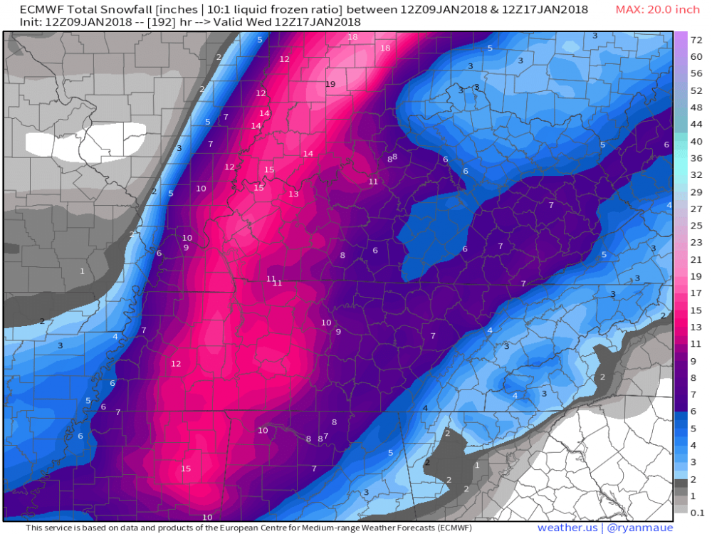
That's both systems combined .....
Even if HSV gets a third of this I'll be happy.
Sent from my SM-J320VPP using Tapatalk
It just looks kind of weird seeing the axis of heavy snow from north to south from IL/IN to MS. Usually its either East to West or SW to NE, etc.
Im guessing a good bit of this in some areas would be ice ?That's both systems combined .....
Sent from my SM-J320VPP using Tapatalk
jaymackd3
Member
yeah I know...just wanted to see the cumulative effect.That's both systems combined .....
Sent from my SM-J320VPP using Tapatalk
StormStalker
Member
Now the Euro is showing this I'm definitely getting more interested in this system. I'm really hoping this pans out because a lot of us are in play here. Especially those that missed out on the first two systems.
Hmm. ULL= fun weather surprises
Stormlover
Member

That torch tho!
")
Storm5
Member
Good looking eps mean

Sent from my SM-J320VPP using Tapatalk

Sent from my SM-J320VPP using Tapatalk
uncheelfan
Member
- Joined
- Jan 6, 2017
- Messages
- 19
- Reaction score
- 18
About a 150 miles south and 150 miles east and alot more folks would be in business!!!!! South East Trend ftw!!!!
Sent from my SCH-I535PP using Tapatalk
Sent from my SCH-I535PP using Tapatalk
Somebody about to get NAM’D!!