• Hello, please take a minute to check out our awesome content, contributed by the wonderful members of our community. We hope you'll add your own thoughts and opinions by making a free account!

Pattern December Doldrums 2025 🎄 ❄️

I think we're going warm for at least the last half of the month. All the long range operational models along with the specific indices, scream warmth.


PNA - Solidly negative the next two weeks
AO - Solidly positive the next 10 days, and then maybe goes towards neutral.
NAO - Slightly positive the next two weeks


Truly I hope it's wrong too and I get the optimism but like the signal is ridiculous. Like I'm legit trying to prepare people here hoping for a white Christmas that it ain't happening lol
 
That is good for the wallet! SE is in the very comfortable zone with those anomalies, as long as we don't get wedged.
I know in years past, warm spells frequently had several CAD events. Because we were in a warm pattern, there was limited arctic air to tap; but it was sufficient to give many 40s and light rain.
 
Yeah I never want to hear about phase 8 ever again. What a joke

Most of the variability subseasonally is Kelvin Wave related anyway, we lost the MJO signal once it hit the edge of the Warm Pool (that normally happens in the western hemisphere but we’ve gone above and beyond that here).

A bigger chunk of the wave variability we’re seeing across the mid latitudes late month into early Jan is internally driven by the extratropics with some low frequency forcing sprinkled in. The stratospheric warming event we saw earlier this month is unfortunately having no impact on things going forward
 
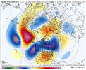
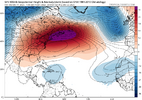
IMG_1939.pngWow, look at that. A 591 (5910 meter) 500 mb height ridge just off the Delmarva coast Christmas morning, 2025. If something like this happens (and other models have the ridge more over the south-central US), record high daily lows around or exceeding 70° or daily highs may be broken from around Dallas to DC just before or around Christmas. The weather will probably feel more like late Spring or early summer for many in the deep southern US this Christmas.
 
Looking at the EPS weeklies, we go above normal next week and stay that way through mid January. The worst of the warmth looks to be the week of Christmas with a gradual cooldown to near normal temperatures in mid January. We have been well below normal for the first half of December so any warmup will seem to be a noticeable change but the most above normal that we will see for any week will be three degrees above normal the week of Christmas. It hurts that the cold air can't hang around throughout the first part of January but with near normal temperatures in mid January we should still have our chances for a winter weather event based on climatology.
 
Last edited:
I was just thinking no flip at all.
Hopefully just like 1989-90. Once it warmed up that winter it stayed there. Our biggest story is going to be the lack of rain though. If it stays dry through the winter, next summer will be one to remember. 2007 again only even hotter this time IF the drought continues.
 
I know in years past, warm spells frequently had several CAD events. Because we were in a warm pattern, there was limited arctic air to tap; but it was sufficient to give many 40s and light rain.
Yeah, even a trash pattern isn’t enough to stop a cold rain around here with CAD. We get plenty of those every winter.
 
View attachment 178729Wow, look at that. A 591 (5910 meter) 500 mb height ridge just off the Delmarva coast Christmas morning, 2025. If something like this happens (and other models have the ridge more over the south-central US), record high daily lows around or exceeding 70° or daily highs may be broken from around Dallas to DC just before or around Christmas. The weather will probably feel more like late Spring or early summer for many in the deep southern US this Christmas.
Euro weeklies continue the above average temps to mid January now per latest .
 
The MJO is stupid

Yeah I never want to hear about phase 8 ever again. What a joke

The MJO isn’t any “stupider” than any other index, and posts about the MJO, which is about as useful as any well followed index, aren’t going to suddenly disappear from this or any reputable wx forecast discussion forum as many will continue to discuss that index like they have for many years. The key is to know how to use this index, which is a tool rather than a crystal ball just like any other index.

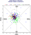
There’s been an ~3 day lag time in getting the official MJO phase/amp. As it turns out, the initial phase 8 lasted only 5 days (12/3-7) as it went into phase 6 on 12/8 (per 1st image), which was totally unexpected. I’ll keep following this closely to see if it re-enters phase 8, which I think has a very good chance but we’ll see.
IMG_6055.gif

Regarding this initial phase 8 (12/3-7), here are the temperature anomalies for some cities in the E half of the US:

- Boston: -8

- NYC: -8

- Baltimore: -7

- RDU: -8

- Atlanta: -7

- Birmingham: -7

- Tulsa: -7

These are on the border of B and MB normal.

Below are the average anomalies for NDJ, which I believe are in degrees F. These average anomalies were well exceeded even if these are in degrees C:
IMG_5610.png

Thus, this was a colder than average phase 8 in the E US based on these 7 cities.

Source for daily temperatures:
 
Last edited:
The MJO isn’t any “stupider” than any other index, and posts about the MJO, which is about as useful as any well followed index, aren’t going to suddenly disappear from this or any reputable wx forecast discussion forum as many will continue to discuss that index like they have for many years. The key is to know how to use this index, which is a tool rather than a crystal ball just like any other index.

There’s been an ~3 day lag time in getting the official MJO phase/amp. As it turns out, the initial phase 8 lasted only 5 days (12/3-7) as it went into phase 6 on 12/8 (per 1st image), which was totally unexpected. I’ll keep following this closely to see if it renters phase 8, which I think has a very good chance but we’ll see.
View attachment 178732

Regarding this initial phase 8 (12/3-7), here are the temperature anomalies for some cities in the E half of the US:

- Boston: -8

- NYC: -8

- Baltimore: -7

- RDU: -8

- Atlanta: -7

- Birmingham: -7

- Tulsa: -7

These are on the border of B and MB normal.

Below are the average anomalies for NDJ, which I believe are in degrees F. These average anomalies were well exceeded even if these are in degrees C:


Thus, this was a colder than average phase 8 in the E US based on these 7 cities.

Source for daily temperatures:
Don't get offended. I post about the MJO too. It was a joke and if I need to reinterpret, I'm happy to. The MJO is acting stupidly hahaha lolol 😁😁 all we can do is laugh. That's what I meant.
 
The MJO isn’t any “stupider” than any other index, and posts about the MJO, which is about as useful as any well followed index, aren’t going to suddenly disappear from this or any reputable wx forecast discussion forum as many will continue to discuss that index like they have for many years. The key is to know how to use this index, which is a tool rather than a crystal ball just like any other index.

There’s been an ~3 day lag time in getting the official MJO phase/amp. As it turns out, the initial phase 8 lasted only 5 days (12/3-7) as it went into phase 6 on 12/8 (per 1st image), which was totally unexpected. I’ll keep following this closely to see if it renters phase 8, which I think has a very good chance but we’ll see.
View attachment 178732

Regarding this initial phase 8 (12/3-7), here are the temperature anomalies for some cities in the E half of the US:

- Boston: -8

- NYC: -8

- Baltimore: -7

- RDU: -8

- Atlanta: -7

- Birmingham: -7

- Tulsa: -7

These are on the border of B and MB normal.

Below are the average anomalies for NDJ, which I believe are in degrees F. These average anomalies were well exceeded even if these are in degrees C:
View attachment 178734

Thus, this was a colder than average phase 8 in the E US based on these 7 cities.

Source for daily temperatures:
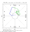
Just randomly went to 6 when none of models had it going to 6 lol. Can’t make this stuff up. That means it can surely go to 8 whenever it decides too right?
 
Don't get offended. I post about the MJO too. It was a joke and if I need to reinterpret, I'm happy to. The MJO is acting stupidly hahaha lolol 😁😁 all we can do is laugh. That's what I meant.

I wasn’t offended. I just want to prevent the possible spread of misinfo about the MJO. The main problem as I see it is that the MJO, like is the case for many indices, is an often misused or misunderstood tool. It is imho as good as any index for general temperature tendencies associated with each of its phases. Sometimes a phase that averages colder (warmer) than normal ends up being warmer (colder) than normal. In this case, this initial phase 8 was actually colder than an average phase 8 as per my prior post.

I intend to similarly keep following any additional phase 8 periods that may occur this month. I expect more phase 8 days.
 
The MJO isn’t any “stupider” than any other index, and posts about the MJO, which is about as useful as any well followed index, aren’t going to suddenly disappear from this or any reputable wx forecast discussion forum as many will continue to discuss that index like they have for many years. The key is to know how to use this index, which is a tool rather than a crystal ball just like any other index.

There’s been an ~3 day lag time in getting the official MJO phase/amp. As it turns out, the initial phase 8 lasted only 5 days (12/3-7) as it went into phase 6 on 12/8 (per 1st image), which was totally unexpected. I’ll keep following this closely to see if it re-enters phase 8, which I think has a very good chance but we’ll see.
View attachment 178732

Regarding this initial phase 8 (12/3-7), here are the temperature anomalies for some cities in the E half of the US:

- Boston: -8

- NYC: -8

- Baltimore: -7

- RDU: -8

- Atlanta: -7

- Birmingham: -7

- Tulsa: -7

These are on the border of B and MB normal.

Below are the average anomalies for NDJ, which I believe are in degrees F. These average anomalies were well exceeded even if these are in degrees C:
View attachment 178734

Thus, this was a colder than average phase 8 in the E US based on these 7 cities.

Source for daily temperatures:
Wow, didn't see that coming! And, worse, it seems to be marching toward the Maritimes with steady momentum :confused:

And to think, the Euro ensemble showed zero support for the MJO moving to the Maritime side of the COD in the short term. We need a U-turn STAT, lol.
1765468380577.png
 
Wow, didn't see that coming! And, worse, it seems to be marching toward the Maritimes with steady momentum :confused:

And to think, the Euro ensemble showed zero support for the MJO moving to the Maritime side of the COD in the short term. We need a U-turn STAT, lol.
View attachment 178735
MJO is dirty and nasty, with kelvin waves interfering with the RMM charts
 
I had said a week ago that my biggest fear was the MJO jumping into phases 4-5-6 after it left 8 and the null phase, looks like that could be ready to happen, how long it stays on the wrong side is anybodys guess. I have had NIGHTMARES about 89-90 where December was frigid and many thought it would carry over until Jan-Feb but, not so fast my friend, it did not.. I am probably the oldest guy here as I turn 3/4 of a century in one month and I have seen a lot of weather and have been more wrong than I have been right, but so have many degreed Meteorologists. Just shows how unpredictable the weather (and Climate for that matter) is but the good news is one day it ill change again, however I will be on the wrong side of the grass by then most likely
 
But seriously no reason to jump off of bridge yet. Early December was supposed to be a torch, it ended up being very cold. The rest of the month was looking great, and now it looks awful. The models have been hot garbage anything over 3 days. It’s gonna change, you can bank on it.
 
The Weather Argument Index running well above normal. WAI: Reliable annual wintertime indicator of favorable or unfavorable winter conditions, as measured by the amount of online whining, bickering, or provoking.

Positive values reflect poor winter conditions (i.e. heat, snow for someone else, death ridges, lack of long range snow maps, and merry torchmas). Negative values reflect favorable winter conditions (i.e. snow in a long range weather app forecast, polar vortex intrusions, long range fantasy snowstorms for a preferred area, and frequent social media postings of favorable upcoming or imminent weather patterns).
 
Last edited:
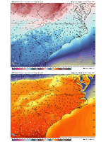
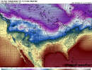
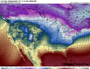
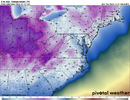
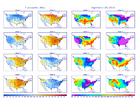
AIGFS keeps the Midwest and Canada cold throughout the run. This is important in that retaining as much of the North American snowpack as possible would mean colder temps later on and tends to suppress the expected zonal storm track.

Outside of a few days, there is no sustained SE torch on this new-fangled toy. The NHC relied heavily on the Google Deep Mind model, so there's that.

Day 10:
1765472641525.png
Christmas Eve morning:
1765472693744.png
 
Back
Top