rburrel2
Member
yall hear that? my storm. ross scores again
yall hear that? my storm. ross scores again
Alan’s first stab at it.
Sent from my iPhone using Tapatalk
This is the kinda system that will give northern Iredell county a quick shot/coating of sleet prior to the warm up and they'll call a 2-hour school delay for the whole county...leaving me waiting in the rain 2 hours to take my daughter to school in Troutman (centralish Iredell).
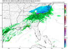
0.5 qpf all frozen…mercy18Z HRRR ripping it at the house predawn Friday morning
18Z HRRR ripping it at the house predawn Friday morning


That can set up anywhere. I'd be ready for a decent burst of snow or sleet if you lived anywhere near the I-85 corridorMercy what a gradient on the hrrr
View attachment 177875
Funny how it always knows where the Wake County line is.Mercy what a gradient on the hrrr
View attachment 177875
Can anyone show me where I-40 is??Mercy what a gradient on the hrrr
View attachment 177875

Canadian Op has it as well. 12z Can Op hits us 3 x within a 7 day stretch.The 12Z EPS is hinting at a 3rd NC snow threat on 12/12 with measurable snow from 7 of the 50 members, mainly from lows that move just offshore:
View attachment 177873

Tell ya what, this system is trending juicer with each cycle…halve these and that's probably about your best case *for most* imo. somebody in the wilkes/surry/yadkin/stokes/forsyth/rockingham counties ballpark might have a higher ceiling than half what's shown below, but that's an absolute best case probably.
i don't buy this for the i-40 corridor (specifically hickory/winston/gso/burlington)
View attachment 177876


Since the NAM “upgrade” I’ve noticed the NAM especially 3k being on dry side.View attachment 177882
The NAM 3km not being juiced is interesting
Yep. I would expect it to fill in a bit more by the 12 z run tomorrow.Since the NAM “upgrade” I’ve noticed the NAM especially 3k being on dry side.
For these kinds of marginal thermal setups, in addition to soundings, I like looking at spatially where the warm nose is aloft and these max T plots from pivotal do a decent job of showing that.
This looks like sleet and freezing rain for the most part in NC, except near the VA border.
View attachment 177856
View attachment 177857
Just on the cold side of the warm nose is usually where your frontogenesis is maximized as warm advection is partially offset by melting snow on the leading edge of the warm nose.
In this case, that would suggest your greatest potential for heavier snow is in southern to eventually central Virginia. You also have to be on the lookout for compensating subsidence in the wake of this frontogenesis/to the south.


That cutoff line tho jeez louise that's basically I-40/85 and North. Everything south of that good luck18z RGEM looks solid.
Be wary of the sharp gradient along I-40 with WAA. I learned my lesson last January when I drove home from Raleigh to Alamance to see more snow, since the HRRR supposedly kept us all snowed in up to verification. The RN/SN line ended up verifying over Roxboro and the VA border, so I am pretty skeptical of this.18z Gfs juiced up the precip too.
View attachment 177886
For sure. If I were to make my best guess, I’d use the latest run of the GEFS and cut the totals in half. I think it gives a pretty good outline about who could see any winter weather and where some accumulation can occur. Lots of sloppy dustings to 1/2” areas.Be wary of the sharp gradient along I-40 with WAA. I learned my lesson last January when I drove home from Raleigh to Alamance to see more snow, since the HRRR supposedly kept us all snowed in up to verification. The RN/SN line ended up verifying over Roxboro and the VA border, so I am pretty skeptical of this.

Unless you live in SW VA where legit solid ratios look to occur. I expect every flake to stick in Blacksburg, VAFor sure. If I were to make my best guess, I’d use the latest run of the GEFS and cut the totals in half. I think it gives a pretty good outline about who could see any winter weather and where some accumulation can occur. Lots of sloppy dustings to 1/2” areas.
18z RGEM looks solid.
Both look great. I would love to just see some snow falling and on the ground this early in winter.18z Gfs juiced up the precip too.
View attachment 177886
Lucky Dog! The only worry you have is how much moisture you get and the resulting rates.Unless you live in SW VA where legit solid ratios look to occur. I expect every flake to stick in Blacksburg, VA
NGL I'm a RGEM fan, it does good work with thermals and it usually breaks more hearts than it mends, but that's at least 2 solid runs in a row. I'm intrigued18z RGEM looks solid.


How much drier?18z euro took a step back and dried up some.
Has not come out on WeatherBell for some reason but here it is on pivotalHow much drier?