Jokes aside, anybody having problems receiving the RWT for WNG706? I have not heard my WR120 go off at all. It is on and has batteries. And plugged in
-
Hello, please take a minute to check out our awesome content, contributed by the wonderful members of our community. We hope you'll add your own thoughts and opinions by making a free account!
You are using an out of date browser. It may not display this or other websites correctly.
You should upgrade or use an alternative browser.
You should upgrade or use an alternative browser.
November 2025
- Thread starter packfan98
- Start date
12Z Ukmet continues to echo the Euro in saying the GFS is flat out garbage
LukeBarrette
im north of 90% of people on here so yeah
Meteorology Student
Member
2024 Supporter
2017-2023 Supporter

Kinda did away with flurries escaping the moutains but still a good look for the mountains for now.
Bigedd09
Member
Mid November is looking quite toasty
SnowNiner
Member
Mid November is looking quite toasty
See grit's post in the winter thread. The u-turn in the maritime tells the tale.

Looks like my question is answered.Jokes aside, anybody having problems receiving the RWT for WNG706? I have not heard my WR120 go off at all. It is on and has batteries. And plugged in
...SPECIAL NOAA WEATHER RADIO TEST THIS EVENING...
THE WARNING ALARM FEATURE OF NOAA WEATHER AND ALL HAZARDS RADIO
WILL BE ACTIVATED AT 6 PM EDT THIS EVENING FOR TEST PURPOSES FOR
RESIDENTS LIVING NEAR THE SHEARON HARRIS NUCLEAR PLANT. THIS
ANNUAL TEST IS BEING CONDUCTED IN COOPERATION WITH DUKE ENERGY,
THE STATE OF NORTH CAROLINA, AND THE NATIONAL WEATHER SERVICE, FOR
THE COUNTIES OF CHATHAM, HARNETT, LEE, AND WAKE. NO ACTION WILL
BE REQUIRED BY THE PUBLIC WHEN THIS TEST IS CONDUCTED. IF THERE IS
A RISK OF ANY TYPE OF HAZARDOUS WEATHER THIS EVENING, THE TEST
WILL BE POSTPONED.
Welcome in!Howdy y'all! I just moved down to Tallahassee for a job and I'm excited to be joining the community here in the southeast. Some of you might recognize me from other forums around, but if not I'm originally from Pennsylvania, moved out to Wyoming for grad school, and now live in Florida. I'm a northerner so you can bet I'm excited for the cold blast next week.
I'm interested to see which locations approach or break record lows. Asheville will be interesting, the record for 11/10 is 18° and the GFS/Euro show lower 20s for lows. Charlotte remains above any records progged on guidance
Actually, per averages, December is colder than February. January is the coldest, followed by December, then February. I suppose the biggest culprit with December not having more winter storms on average is that the mean storm track is still moving south, probably bottoming out in the late Jan to early Feb timeframe.I get it. January/February average temp is colder than December thus we average more snow in January and February imby. The likelihood of getting snow, even with below normal temps in Dec is therefore less than in jan and feb.
I would rather it be in January to increase my chances for winter weather, but with the last decade being so warm all months I’ll take whatever I can get. Hopefully it can get super cold in Dec and we can have some fun.
November troughs I have zero expectations and just enjoy strange cool weather.
Here are averages for Charlotte - Dec / Jan / Feb / Mar since 1877:

Charlotte - Dec / Jan / Feb / Mar since 1999:

For good measure, here is Birmingham - Dec / Jan / Feb / Mar since 1896:

Drizzle Snizzle
Member
I’m guessing Feb is warmer than Dec largely because of the 2nd half of Feb which can get pretty warm sometimes.Actually, per averages, December is colder than February. January is the coldest, followed by December, then February. I suppose the biggest culprit with December not having more winter storms on average is that the mean storm track is still moving south, probably bottoming out in the late Jan to early Feb timeframe.
Here are averages for Charlotte - Dec / Jan / Feb / Mar since 1877:
View attachment 176060
Charlotte - Dec / Jan / Feb / Mar since 1999:
View attachment 176062
For good measure, here is Birmingham - Dec / Jan / Feb / Mar since 1896:
View attachment 176063
Like Bill Parcells used to say though, you are what your record says you are. Same here. Plenty of reasons why Decembers can be warm, just like February.I’m guessing Feb is warmer than Dec largely because of the 2nd half of Feb which can get pretty warm sometimes.
tonysc
Member
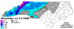
We got 3-4 inches of snow across the upstate of SC on November 12 1968. The forecast that afternoon said, rain changing to snow after dark. I was looking out at the street light in front of our house and witnessed moderate to heavy rain, change to moderate to heavy snow instantly. https://www.dnr.sc.gov/climate/sco/climatedata/events/snow_24_11.php
I could be mistaken, but although February averages colder at the surface than December, aren't the upper levels typically colder in February?Actually, per averages, December is colder than February. January is the coldest, followed by December, then February. I suppose the biggest culprit with December not having more winter storms on average is that the mean storm track is still moving south, probably bottoming out in the late Jan to early Feb timeframe.
Here are averages for Charlotte - Dec / Jan / Feb / Mar since 1877:
View attachment 176060
Charlotte - Dec / Jan / Feb / Mar since 1999:
View attachment 176062
For good measure, here is Birmingham - Dec / Jan / Feb / Mar since 1896:
View attachment 176063
to put into perspective the hilarity of a trough the euro suite continues to send our way, the op has had lake effect flurries off lanier ga and hartwell sc for several runs consecutively on monday afternoon (THIS IS NOT AN ENDORSEMENT OF THAT SOLUTION I AM NOT THAT MUCH OF A WEENIE), and the -ensemble mean- looks like this for the middle of the afternoon on november 10th. and it's been slowly trending colder for days. that's pretty wild!

Brent
Member
Pretends to be shocked....
People claim that it fixed the progressive issues it has but I still keep seeing it all the time. I make forecasts for my internship with AEM-Earth Networks and for the WxChallenge and have been ignoring the GFS for the last 6 months or so. It has been straight up awful....
Just to add to this but the GFS was straight up embarrassing with Melissa for days..... Even when it got painfully obvious it was wrong!
Good call out. This is the long term climatology map for 850mb temperatures in Dec and Feb where temperatures aloft here are indeed colder in Feb compared to Dec on average in most areas of the country, including the SE. That goes along with the farther south storm track in the means as well for Feb (vs Dec) when looking at the 500mb height maps. Heights in March are actually a touch south of December in the means in the E U.S. (not shown below).I could be mistaken, but although February averages colder at the surface than December, aren't the upper levels typically colder in February?
Note: I think in the first part of your message where you state "although Feb averages colder at the surface than Dec"....I think you meant to say the reverse - Dec averages colder at the sfc than Feb. Although, even looking at that on the maps, there are some areas where Feb is colder than Dec at the surface, like the far north central states into the northeast.

"I think in the first part of your message where you state "although Feb averages colder at the surface than Dec"....I think you meant to say the reverse - Dec averages colder at the sfc than Feb"Good call out. This is the long term climatology map for 850mb temperatures in Dec and Feb where temperatures aloft here are indeed colder in Feb compared to Dec on average in most areas of the country, including the SE. That goes along with the farther south storm track in the means as well for Feb (vs Dec) when looking at the 500mb height maps. Heights in March are actually a touch south of December in the means in the E U.S. (not shown below).
Note: I think in the first part of your message where you state "although Feb averages colder at the surface than Dec"....I think you meant to say the reverse - Dec averages colder at the sfc than Feb. Although, even looking at that on the maps, there are some areas where Feb is colder than Dec at the surface, like the far north central states into the northeast.
View attachment 176068
lol, yes. Age is catching up with me.
And, great point about the heights/storm track.
If one were to foolishly consider the GFS OP at this range, the 18z run cancels the much-anticipated November torch with yet another deep eastern trough next weekend, with reinforcing shots of cold air right through the end of its run.

If you want to learn from A-Z all about polar vortex, stratospere,Troposphere circulation, etc, how it affects us This is as clean, easy to read article as you will find. Even has some cool 3d graphs of the pv as well. 10 mins of reading will make you alot more wx savy, comprehensive of pattern recognition, terminology etc. Just Passing along. Enjoyable read.

 www.severe-weather.eu
A significant Polar Vortex slowdown is forecast, bringing Cold Weather for Winter 2025/2026
Winter 2025/2026 in the United States and Canada will start with cold and snow, as a Polar Vortex warming event is forecast for December
www.severe-weather.eu
Gets tidewater, northern obx as well.to put into perspective the hilarity of a trough the euro suite continues to send our way, the op has had lake effect flurries off lanier ga and hartwell sc for several runs consecutively on monday afternoon (THIS IS NOT AN ENDORSEMENT OF THAT SOLUTION I AM NOT THAT MUCH OF A WEENIE), and the -ensemble mean- looks like this for the middle of the afternoon on november 10th. and it's been slowly trending colder for days. that's pretty wild!
View attachment 176066
SimeonNC
Member
I still think flurries east of the mtns in the Carolinas is possible Monday with the trough. I think the mesoscale models will have a better hold on the clipper once they get in range
MRKEVIN7575
Member
I heard mention about a stratosphere wave reflection event starting around Alaska in the 6-15 day on the ensembles
BrickTamland
Member
The weather this weekend into next week.

NBAcentel
Member
Icon with a Charlotte bullseye 

57 years later to the day let’s make it happen captainIcon with a Charlotte bullseye
Attachments
AJ1013
Member
I know you all are chasing snow, etc (making me jealous), but even for my region the model outputs I'm seeing are near unprecedented. The ICON has 57/44 here on veterans day which would shatter all sorts of records. 57/44 here would be considered frigid in January let alone early-mid November! I don't think I'll get that cold but even the EPS mean of 70/50 would be the coldest day in the first half of November in a decade for us. Exciting event to follow regardless. I think I'll post the 00z Icon mins just since it's making me salivate haha

tennessee storm
Member
Trough coming down thanksgiving week , needs be watched for severe weather for sureThe weather this weekend into next week.
SimeonNC
Member
And the 00z Euro brings back this idea although more into Monday nightI still think flurries east of the mtns in the Carolinas is possible Monday with the trough. I think the mesoscale models will have a better hold on the clipper once they get in range
SimeonNC
Member

Ignoring the specific amounts, I think this is a more realistic solution for the entire EC than the GFS. Considering the rather warm lake temps, there should be widespread lake effect snow showers from Chicago points eastwards With sig lake-enhanced NW flow in the mountains.
Who will win the Snow Flurry sweepstakes? Icon says Charlotte, latest Euro says the senior saints of Halifax County/Roanoke Rapids.

77 East might see a few flurries.I still think flurries east of the mtns in the Carolinas is possible Monday with the trough. I think the mesoscale models will have a better hold on the clipper once they get in range
I think this is too aggressive and will back off as we get into the weekend. It's definitely a very anomalous trough, but the Euro is probably a little too robust, which will impact snow chances east of the mountains.Who will win the Snow Flurry sweepstakes? Icon says Charlotte, latest Euro says the senior saints of Halifax County/Roanoke Rapids.
View attachment 176086
Whether it snows or not, it will still be a big time fall front that will be fun to experience.
- Joined
- Jan 23, 2021
- Messages
- 4,604
- Reaction score
- 15,203
- Location
- Lebanon Township, Durham County NC

Newfound gap deluxeWho will win the Snow Flurry sweepstakes? Icon says Charlotte, latest Euro says the senior saints of Halifax County/Roanoke Rapids.
View attachment 176086

i keep waiting for our trough to start ticking north or flatten out some but it hasn't yet. still only thursday, but the consistency is nice.

spc added a saturday marginal for a good chunk of the deep south and into SC. most eps members depict workable instability and with that big ol front approaching, some nocturnal elevated stuff seems probable into sunday morning.

lastly... 18/50 eps members created even the lightest mischief east of the mtns at 06z (and i'm being generous with my definition of "mischief"). i wouldn't hang any hope on it
spc added a saturday marginal for a good chunk of the deep south and into SC. most eps members depict workable instability and with that big ol front approaching, some nocturnal elevated stuff seems probable into sunday morning.
lastly... 18/50 eps members created even the lightest mischief east of the mtns at 06z (and i'm being generous with my definition of "mischief"). i wouldn't hang any hope on it
SimeonNC
Member
I honestly don't think the Euro is aggressive enough for certain regions such as central Ohio, PA, NY, ect but I agree with you for areas closer to us.I think this is too aggressive and will back off as we get into the weekend. It's definitely a very anomalous trough, but the Euro is probably a little too robust, which will impact snow chances east of the mountains.
Whether it snows or not, it will still be a big time fall front that will be fun to experience.
Here’s my current NWS forecast low for Nov 11th:
MONDAY NIGHT
CLEAR. LOWS AROUND 30.
- If this verifies, it would be the earliest freeze at KSAV since the 11/7 32 low of 2010
-If it gets down to the predicted 30, that would be the coldest so early in the season since way back in 1976!
Link:
MONDAY NIGHT
CLEAR. LOWS AROUND 30.
- If this verifies, it would be the earliest freeze at KSAV since the 11/7 32 low of 2010
-If it gets down to the predicted 30, that would be the coldest so early in the season since way back in 1976!
Link:
For the weekend into Monday setup, at the start of the loop, the GFS sends the lead shortwave from Missouri into Ohio - that's the cold front that moves thru on Sunday. After that for Monday, the GFS bifurcates the vort max wave energy that is diving within the digging trough, with part of it working thru the Great Lakes, and other pieces working into the S Apps / S GA

The Euro has the better solution as it keeps the trailing vort max energy consolidated in a stronger packet that dives into the Carolinas. The 2 step process is a good one in these types of setups where you first get the initial cold front thru to cool things down, then bring in the consolidated vort max along a good track to spark precipitation within the colder air. Problem here is, the Euro is on an island at the moment with these details within the broader setup.

The Euro has the better solution as it keeps the trailing vort max energy consolidated in a stronger packet that dives into the Carolinas. The 2 step process is a good one in these types of setups where you first get the initial cold front thru to cool things down, then bring in the consolidated vort max along a good track to spark precipitation within the colder air. Problem here is, the Euro is on an island at the moment with these details within the broader setup.
that point i bolded is the only thing keeping me vaguely interested in this low potential. not really a cold chasing moisture setup at all, the initial cold push is well removed from a stout h5 vort max swinging in. the euro has been consistent with this scenario for a few runs now.For the weekend into Monday setup, at the start of the loop, the GFS sends the lead shortwave from Missouri into Ohio - that's the cold front that moves thru on Sunday. After that for Monday, the GFS bifurcates the vort max wave energy that is diving within the digging trough, with part of it working thru the Great Lakes, and other pieces working into the S Apps / S GA
View attachment 176091
The Euro has the better solution as it keeps the trailing vort max energy consolidated in a stronger packet that dives into NC. The 2 step process is a good one in these types of setups where you first get the initial cold front thru to cool things down, then bring in the consolidated vort max along a good track to spark precipitation within the colder air. Problem here is, the Euro is on an island at the moment with these details within the broader setup.
View attachment 176092

SnowNiner
Member
Gets cold next week. Then the trough shifts east, and we get back to warm beautiful SE ridge weather. I kinda love it (what's wrong me, I'm going warminista?). I bet we wedge a bit at times with the -NAO but the western trough hangs out mid-late November. I guess it's the fall leaves, sunshine, and low 70s, it's just really nice. Maybe December we convert to winter, but I'm enjoying November. 


Brother.
