lexxnchloe
Member
The thing is we’re getting to the time of the year where development is favored to occur in the western Caribbean.The ridge in the Atlantic has been too far east, which has allowed the systems to turn more ne instead of the nw or west track from last year imo
East of the Leeward Islands:
A tropical wave located about 400 miles east of the Leeward Islands
continues to produce disorganized showers and thunderstorms.
Environmental conditions appear marginally conducive for slow
development over the next few days as the wave moves quickly
westward to west-northwestward at 15 to 20 mph. By the latter part
of this week, the system is expected to slow down and turn more
northwestward, and a tropical depression could form late this week
when the system is over the southwestern Atlantic Ocean or near the
Bahamas. Regardless of development, gusty winds and showers are
expected to affect portions of the Leeward Islands late tonight and
Tuesday.
* Formation chance through 48 hours...low...10 percent.
* Formation chance through 7 days...medium...40 percent
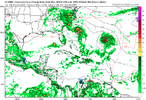
I believe this is the thing the GFS has getting close to the east coast by next weekend
Both the orange and red area look good out there tbh. If the orange area keeps generating convection, I'm sure it'll generate some confusion for the models
Would that lead to major flooding?Joaquin all over againView attachment 174995
If memory serves me correct all models showed Joaquin moving Northwest into the east coast of the US but the exception of the euro which had him going Northeast and I believe the Euro was the only correct modelJoaquin all over againView attachment 174995
Joaquin all over againView attachment 174995

The two disturbances in the Atlantic bear watching, especially the western most one. The eastern disturbance is the one with the highest chance of development as of now, however, the forecast cone shows it following on the heels of Gabrielle and out to sea. The other disturbance will take longer to develop due to westerly shear but if it can get its act together it would be in a more favorable position to affect the East Coast in coming days.
And ominously has a ULL centered over northern Alabama that would tend to feed that circulation back towards the coast and perhaps also provide a favorable outflow jet for strengthening
View attachment 175006

That's my kind of setup. Storm sits for a while, long enough to becomes extratropical and help pull down cool air. It would actually give it a Fall(ish) feel. Would be a lot of rain in the coastal areas.
Euro interestinggoood morning euroView attachment 175016
Question for you men. Why is the Gulf so quite this year?
