Finally getting a good soaking rain here. Its been nearly a month.
-
Hello, please take a minute to check out our awesome content, contributed by the wonderful members of our community. We hope you'll add your own thoughts and opinions by making a free account!
You are using an out of date browser. It may not display this or other websites correctly.
You should upgrade or use an alternative browser.
You should upgrade or use an alternative browser.
Pattern Sweatember
- Thread starter SD
- Start date
Yeah this gives them a better chance but I’d still expect issues in the second half.Yeah, I was busy thinking about other stuff while I had Gameday on and spotted this.
Checked the HRRR and yeah...yuck. I'm not as familiar with where Clarke County is lol, but even with this move, they may well have an hour to hour and a half at most.
HRRR highlighting some 40-50mph gusts may be possible somewhere in North GA

lexxnchloe
Member
Perfect pattern for dec-feb. If only we werent going back to an east coast ridge when cane season ends.

Storms are forming!
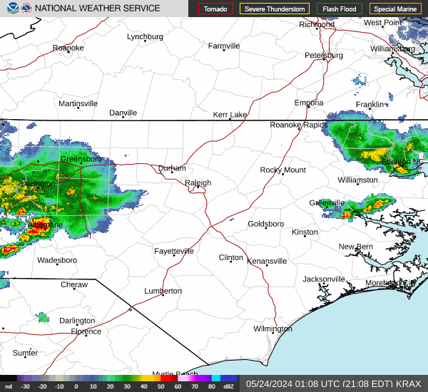
SEVERE THUNDERSTORM WARNING FOR GUILFORD
The National Weather Service in Raleigh has issued a
* Severe Thunderstorm Warning for...
Northern Guilford County in central North Carolina...
* Until 300 PM EDT.
* At 209 PM EDT, a severe thunderstorm was located near Greensboro,
moving northeast at 15 mph.
HAZARD...60 mph wind gusts and penny size hail.
SOURCE...Radar indicated.
IMPACT...Expect damage to roofs, siding, and trees.
* Locations impacted include...
Greensboro, High Point, McLeansville, Summerfield, Stokesdale, Lake
Townsend Marina, Lake Townsend, Lake Jeanette Marina, Monticello,
and Lake Brandt.
PRECAUTIONARY/PREPAREDNESS ACTIONS...
For your protection move to an interior room on the lowest floor of a
building.
Straight line winds can blow down trees, power lines, and damage
mobile homes and other buildings. Seek shelter in a sturdy structure
until the storm has passed. Stay away from windows as flying debris
generated by damaging winds can be deadly.
&&
LAT...LON 3624 7954 3614 7955 3602 8004 3619 8004
3625 7995
TIME...MOT...LOC 1809Z 240DEG 13KT 3614 7990
HAIL THREAT...RADAR INDICATED
MAX HAIL SIZE...0.75 IN
WIND THREAT...OBSERVED
MAX WIND GUST...60 MPH

Welp outflowed. This dry streak should hit 40 easy, 60 looks doable
GeorgiaGirl
Member
Dawgs apparently suck this year, but this is one heck of a capture at Sanford Stadium...

Getting trained over 3 inches and still dumping FFW in effect.
Basically, had a hand few of drops fall@SD Getting blanked again?
We got a sprinkle here but behind that there might be more rain on the way according to radar. We in Southern Wake County certainly could use it.
JHS
Member
Got hit twice here today with heavy rain both times and still is raining lightly.
JHS
Member
I think you get it good soon. There is a big batch of storms southwest of Raleigh.Basically, had a hand few of drops fall
InboundBasically, had a hand few of drops fall
.06 lol
Sink zone.06 lol
Anger unsinkingSink zone


I ended up with .40 inches of rain last night from the storms that rolled through the area. This will at least settle the dust and perk the vegetation up which had been looking stressed due to the lack of precipitation
.03 yesterday. Temp of 93 yesterday and currently 65, almost 30° temp change, it's noticeable
Just went from 77 to 68 here.03 yesterday. Temp of 93 yesterday and currently 65, almost 30° temp change, it's noticeable
nice heatwave on the euro
Shaggy
Member

How did you get access to SD's radarscope app?
It does look very familiarHow did you get access to SD's radarscope app?
Hate its gonna be cloudy tonight. Gonna miss a show.
3:25PM: I’m getting a thunderstorm now, the first rain here this month.
That first tstorm gave me only a little rain. But a stronger storm is starting now just before 6PM with very gusty winds, heavy rains, and some nearby CTG lightning.
SPECIAL WEATHER STATEMENT
NATIONAL WEATHER SERVICE CHARLESTON SC
548 PM EDT SUN SEP 7 2025
GAZ118-119-072215-
COASTAL CHATHAM GA-INLAND CHATHAM GA-
548 PM EDT SUN SEP 7 2025
...A STRONG THUNDERSTORM WILL IMPACT CHATHAM COUNTY UNTIL 615 PM
EDT...
AT 548 PM EDT, DOPPLER RADAR WAS TRACKING A STRONG THUNDERSTORM OVER
HUTCHINSON ISLAND, MOVING SOUTHEAST AT 10 MPH.
HAZARD...WIND GUSTS UP TO 50 MPH.
SOURCE...RADAR INDICATED.
IMPACT...GUSTY WINDS COULD KNOCK DOWN TREE LIMBS AND BLOW AROUND
UNSECURED OBJECTS.
LOCATIONS IMPACTED INCLUDE...
DOWNTOWN SAVANNAH, HUTCHINSON ISLAND, MIDTOWN SAVANNAH, HUNTER
ARMY AIRFIELD, WINDSOR FOREST, GARDEN CITY, THUNDERBOLT, SAVANNAH
HISTORIC DISTRICT AND SANDFLY.
———————
**Edit: I ended up with ~0.90”
Last edited:
Shaggy
Member
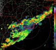
It's uncanny how they dance all around me. This one is reforming east but i am getting some downpours finallyHow did you get access to SD's radarscope app?
.gif")
Shaggy
Member
Power knocked out for a few seconds and have had several brown outs
Avalanche
Member
I’ve had a very good downpour, and with a good breeze. Perfect for porch sitting and watching!! Power is out now, hope yours is still on for football!!
Shaggy
Member
Doughnut holes .png")
I used to see the exact same animation all the time in SE Wake.It's uncanny how they dance all around me. This one is reforming east but i am getting some downpours finallyView attachment 174831
Its amazing how this front is basically going to parallel the beaches for a week
Avalanche
Member
Is Buffalo Bills throwing snowballs yet?
They ought to be throwing confetti after scoring 18 points last few mins of the game to win by 1. Talk about Ravens choke job for the ages. Bills have best QB in the business imo!Is Buffalo Bills throwing snowballs yet?
Greensboro sitting at -4.7 BN so far for Sept. This after August -4 BN. Keep the streak alive till Easter, would be Bueno!
Need to pull that day 5 cutoff about 150 miles SW and its off to the races