• Hello, please take a minute to check out our awesome content, contributed by the wonderful members of our community. We hope you'll add your own thoughts and opinions by making a free account!

Pattern May or May not

about 1.36~ closing in on 1.50" of precip here in Topsail..
Just enough "training" and lift for back building Rains coming off the Ocean..

Some were quite the gully washers!

73F
Low this morning of 68F
SE winds @ 12/13mph.
humidity 97%
dew point 72.1
Pressure º30.23
 
Sitting at 3.96" since 5/1. Good rain but somewhat ominous the ponds and swamps aren't really filling up. Just shows how dry the soils are it's not running off. At the end of April we were 2"-5" below our average soil moisture content for this time of year.

Lots of re-seeded corn is popping which is nice. Hopefully this is the start of a more normal rainfall pattern. It'll all be for naught if we go the next 3 weeks without rain again.

ILM says the overnight stuff coming through and scattered storms the next couple of days should get us another 1" or more.
 
@ChrisAMB, opined, ditches etc.. are NOT filling, nor ponding, ground soils are soaking it up..

Same here..

Hopefully, this will help fire fighting efforts in Horry/Brunswick/Onslow/Pender counties..
 
@ChrisAMB, opined, ditches etc.. are NOT filling, nor ponding, ground soils are soaking it up..

Same here..

Hopefully, this will help fire fighting efforts in Horry/Brunswick/Onslow/Pender counties..

Burn ban has officially been lifted but it's not like it was being enforced anyway. Lots of areas driving around you see where fires got out of control and FD had to put them out. Police seem allergic to writing citations for that sort of thing.
 
Top 10 wettest May on record already for CHA. Only need another 1.40" in the next 19 days to get into the top 5.

At KSAV (airport), rainfall is already up to a whopping 7.9” for May 1-12! That’s over 6 times the normal for that period and more than double the normal for the full month. It is already up to 9th wettest May on record back to the 1870s and 2nd wettest to 1915 for the wettest May 1-12 on record. There remains lots of standing water in low spots, including the back portion of MBY.

Other than the flooding in some low areas, this has been quite beneficial since the area had just been in a moderate drought per the monitor.
 
Last edited:
Road closures throughout the Coastal Empire caused by flooding:

CANDLER COUNTY, Ga. (WSAV) – After weekend storms, many roads are still washed out or impassable in rural parts of the Coastal Empire, like Bulloch, Tattnall and Candler counties.

WSAV visited Candler County Monday and found several dirt roads flooded with ankle-deep water as well as significant infrastructure damage in some areas.

When asked about the flooding Candler County Sheriff John Miles said, “We’ve seen between five and ten inches of rain, and what that did was impact a lot of our county roads. We had some roads that were just muddy, and we had some roads that were almost completely washed out.”

 
Columbia, SC, has had 6.83” during May 1-12. Going back to 1888, that’s the 2nd wettest for 5/1-12 with only 2002 slightly wetter at 7.64”!
 
Is this possibly a wall cloud? I don’t think it is as no watches or warnings here but interesting nonetheless. This is 85 at exit 65 in Rowan County NC
 

Attachments

  • IMG_1037.jpeg
    IMG_1037.jpeg
    922.5 KB · Views: 24
Is this possibly a wall cloud? I don’t think it is as no watches or warnings here but interesting nonetheless. This is 85 at exit 65 in Rowan County NC
Appears to be a weak shelf cloud, not a wall cloud.
 
SVR now in effect for Scotland, Hoke and Parts of Moore County until 345p
Severe Thunderstorm Warning
NCC007-153-165-131945-
/O.NEW.KRAH.SV.W.0090.250513T1846Z-250513T1945Z/

BULLETIN - IMMEDIATE BROADCAST REQUESTED
Severe Thunderstorm Warning
National Weather Service Raleigh NC
246 PM EDT Tue May 13 2025

The National Weather Service in Raleigh has issued a

* Severe Thunderstorm Warning for...
Scotland County in central North Carolina...
Southeastern Anson County in central North Carolina...
Richmond County in central North Carolina...

* Until 345 PM EDT.

* At 246 PM EDT, a severe thunderstorm was located near Wallace, or 8
miles north of Cheraw, moving east at 30 mph.

HAZARD...Quarter size hail.

SOURCE...Radar indicated.

IMPACT...Damage to vehicles is expected.

* Locations impacted include...
Laurinburg, Rockingham, Hamlet, Maxton, Hoffman, Ellerbe, Dobbins
Heights, Wagram, Gibson, and East Laurinburg.

PRECAUTIONARY/PREPAREDNESS ACTIONS...

This storm is producing large hail. SEEK SHELTER NOW inside a sturdy
structure and stay away from windows!

Large hail, damaging wind, and continuous cloud to ground lightning
are occurring with this storm. Move indoors immediately. Lightning is
one of nature`s leading killers. Remember, if you can hear thunder,
you are close enough to be struck by lightning.

&&

LAT...LON 3470 7955 3480 7968 3481 7996 3510 7998
3514 7959 3512 7957 3508 7958 3507 7957
3506 7948 3496 7936 3494 7935 3489 7935
3486 7934 3482 7936 3477 7933 3470 7940
TIME...MOT...LOC 1846Z 265DEG 28KT 3481 7985

HAIL THREAT...RADAR INDICATED
MAX HAIL SIZE...1.00 IN
WIND THREAT...RADAR INDICATED
MAX WIND GUST...<50 MPH

$$
 
EFfakdT.jpeg

Final stats for Sun/AM Mon PLUS an additional 0.47 inches
Almost TWO inches of rain... And it feels like a sauna outside. 74 for dewpoint and highs are already in the 80s! 😱
 
Got ~1.2" the last couple of days. That's below what was originally forecasted but I'll take it anyways. Be nice to score a storm before it dries up Thursday.
 
Wound up with 4.96" after another brief storm this afternoon. Finally saw some ponding in a couple low areas so the ground is finally saturated. Most rain we've had in a month since August 2024.

For the time being I'm going to willfully ignore the models shutting the tap off until Memorial Day for Florida, lower GA and most of SC. Just gonna enjoy everything being green for once.
 
Although yesterday had no rainfall at KSAV, there currently is an isolated thunderstorm over KSAV currently.
 
Interested to see if we can get into a NW flow MCS type pattern later this weekend into mid next week. Also that cold shot Memorial day weekend record lows should be safe but a few days with lows in he 40s and highs in the 60s/70s seem likely
Not a fan of the cooler temps for Memorial Day. That's the start of summer. Would rather it be 80s.
 
SPS issued for GSO!
WWUS82 KRAH 141535
SPSRAH

Special Weather Statement
National Weather Service Raleigh NC
1135 AM EDT Wed May 14 2025

NCZ022-023-141630-
Guilford NC-Alamance NC-
1135 AM EDT Wed May 14 2025

...SHOWERS AND THUNDERSTORMS WITH VERY HEAVY RAIN WILL IMPACT
NORTHERN GUILFORD AND PORTIONS OF ALAMANCE COUNTIES THROUGH 1230 PM
EDT...

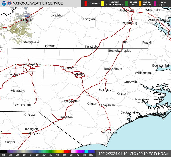
At 1130 AM EDT, Doppler radar was tracking a cluster of strong
thunderstorms from near Summerfield to Lake Townsend and Monticello,
moving north at 20 mph. Other showers with heavy rain were located
just southwest of Burlington, moving northeast at 20 mph.

HAZARD...Very heavy rain up to 1 inch in 30 minutes, wind gusts to
30 mph.

SOURCE...Radar indicated.

IMPACT...Minor flooding of urban and poor drainage areas is expected.

Locations impacted include...
Burlington, Graham, Mebane, Elon, McLeansville, Summerfield,
Gibsonville, Stokesdale, and Haw River.

PRECAUTIONARY/PREPAREDNESS ACTIONS...

If outdoors, consider seeking shelter inside a building.

Torrential rainfall is also occurring with this storm and may lead to
localized flooding. Do not drive your vehicle through flooded
roadways.

&&

LAT...LON 3624 7957 3624 7953 3625 7953 3624 7927
3588 7926 3609 8004 3626 8004
TIME...MOT...LOC 1530Z 194DEG 19KT 3618 7972

MAX HAIL SIZE...0.00 IN
MAX WIND GUST...30 MPH

$$

PWB
 
SVR for Danville!
WUUS51 KRNK 141552
SVRRNK
NCC033-157-VAC089-143-590-141645-
/O.NEW.KRNK.SV.W.0049.250514T1552Z-250514T1645Z/

BULLETIN - IMMEDIATE BROADCAST REQUESTED
Severe Thunderstorm Warning
National Weather Service BLACKSBURG VA
Issued by National Weather Service Raleigh NC
1152 AM EDT Wed May 14 2025

The National Weather Service in BLACKSBURG has issued a

* Severe Thunderstorm Warning for...
Eastern Rockingham County in north central North Carolina...
Northwestern Caswell County in north central North Carolina...
The City of Danville in south central Virginia...
Southwestern Pittsylvania County in south central Virginia...
Southeastern Henry County in south central Virginia...

* Until 1245 PM EDT.

* At 1152 AM EDT, a severe thunderstorm was located over Reidsville,
moving northeast at 25 mph.

HAZARD...60 mph wind gusts and quarter size hail.

SOURCE...Radar indicated.

IMPACT...Hail damage to vehicles is expected. Expect wind damage
to roofs, siding, and trees.

* Locations impacted include...
Danville...
Eden...
Reidsville...
Wentworth...
Bethel...
Axton...
and Camp Springs.

PRECAUTIONARY/PREPAREDNESS ACTIONS...

Prepare immediately for large hail and damaging winds. For your
safety, move to an interior room on the lowest floor of a sturdy
building. Stay away from windows.

When it is safe to do so, please send your reports of hail of any
size, as well as reports of any wind damage, including downed trees
or large limbs, to the National Weather Service by calling toll free
at 1...8 6 6...2 1 5...4 3 2 4. Reports and pictures can also be
shared on the National Weather Service Blacksburg Facebook page and
on Twitter.

&&

LAT...LON 3624 7956 3634 7982 3676 7977 3673 7946
3657 7921
TIME...MOT...LOC 1552Z 207DEG 21KT 3637 7968

HAIL THREAT...RADAR INDICATED
MAX HAIL SIZE...1.00 IN
WIND THREAT...RADAR INDICATED
MAX WIND GUST...60 MPH

$$

22
 
Back
Top