Could be a significant day, especially by June standards. All hazards possible. Stay safe everybody!

Could be a significant day, especially by June standards. All hazards possible. Stay safe everybody!
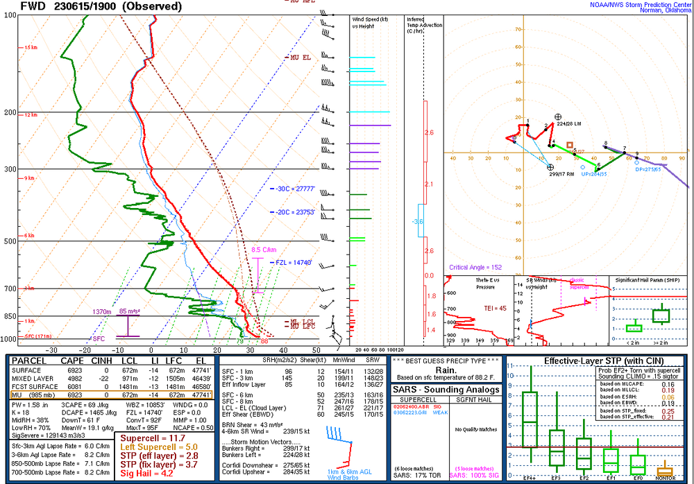
View attachment 135445
James Spann who has been doing the weather in this state for decades "I can't recall the last time we had a moderate risk in this area in June"


This would be not great for the Birmingham metro this afternoon. Not sure it would be a huge tornado threat but probably some massive hail View attachment 135447
Severe thunderstorm watches are not out of the ordinary in Mid June but tornado watches are pretty unusual.A tornado watch in mid June and without a tropical system. What universe are we in? View attachment 135448
Yeah. Supercells rapidly developing in southwest Alabama. Also a spotter report of a tornado with one of them.I think South GA should be under a tornado watch. There’s already a tornado warning !
It is nowI think South GA should be under a tornado watch. There’s already a tornado warning !
As far north as Heard County it looks like.It is now


I guess you cant say melon anymore. PC police will getcha“DVD sized hail” Cant recall many watches mentioning that big of hail.View attachment 135459
What is a DVD? Why not just say "grapefruit"? Seriously, who still uses DVD's?I guess you cant say melon anymore. PC police will getcha
I doWhat is a DVD? Why not just say "grapefruit"? Seriously, who still uses DVD's?

