This one’s a beauty


True enough cold chasing moisture rarely works out, but this is not quite that....this system is developing in the cold air. .The moisture is riding behind the front before it develops in the front of the boundary. But the Lp needs to be a litttle farter south or stronger and more neg for me to feel good about snow.ENS are being skewed HEAVILY by 1 or 2 members. Cold chasing moisture very rarely ever works out for anywhere but the mountains. Now if a secondary low can pop like on the NAM, its a whole new ballgame, but more than likely not going to happen. Flakes will fly, but such a small window for accumulations....bring Spring!

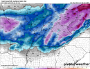
12Z NAM further south
View attachment 115084


About half of those members might move by winter grade up to a B at least. We're moving in a week so it would be nice to get one last snow at the old homeplace.


 12Z Euro temps


Oh my, don't like that...is this gonna do that to us this late in the game...geez18Z GFS moved the wrong way
View attachment 115145

18z GEFS through 6pm Saturday View attachment 115148

Maybe not for you but us up here in the Tennessee Valley still stand a chanceNo snow for Alabama you weenies are getting your hopes too high ???


.png")