Going to go ahead and start this. Some HSLC potential
-
Hello, please take a minute to check out our awesome content, contributed by the wonderful members of our community. We hope you'll add your own thoughts and opinions by making a free account!
You are using an out of date browser. It may not display this or other websites correctly.
You should upgrade or use an alternative browser.
You should upgrade or use an alternative browser.
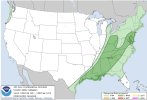
Severe Severe Threat Dec 10-12 2021
- Thread starter SD
- Start date
accu35
Member
Why not!!
StormWatch
Member
I'm starting off in this thread by introducing the mmfs - mesoscale model and forecast system. (I'll elaborate more on the mmfs in the Whamby thread soon.) For us in North GA, the mmfs is showing the squall line holding together as it progresses east, and storms after the main line. There would be strong straight line winds with the squall as the model is indicating a sharp cut off along the squall. This is a long range mesoscale model and of course it can change. The frame from the model is valid at 23z (6pm) this Saturday.
Edit: The 0z data is coming in now.

Edit: The 0z data is coming in now.

Last edited:


StormWatch
Member
The new data from the mmfs is indicating cells ahead of the cold front along the MS River and northeast from there into TN. This is valid at 08:00UTC (3am) Saturday. The mmfs is indicating that these cells would have rotation - introducing tornado and high wind risk. The model is still indicating a squall line developing as the front pushes east. For the NC friends, the mmfs is indicating a storm risk, but the higher chance of storms would be mostly west of the mountains.


HSVweather
Member

tennessee storm
Member
Midsouth Memphis to Nashville under a enhanced risk tomorrow evening. With hatched 10 percent tornado risk … see how today’s runs go if instability is slightly underdone a upgrade to moderate risk could follow latter outlooks lower level jet looks to be screaming overnight hours tomorrow nite won’t help things
HSVweather
Member
 Latest day 2 has shifted the enhance slightly east
Brent
Member
Big tornado hatch tomorrow night... Mentioning long lived tornadoes
Fountainguy97
Member
FV3 is a supercell printer. Check out this ridiculously large supercell it has tonight.
Hrrr and NAM form a line much quicker than fv3 which would help limit discreet cells.

Hrrr and NAM form a line much quicker than fv3 which would help limit discreet cells.
cd2play
Member
Wondering if we see upgrades to moderate risksBig tornado hatch tomorrow night... Mentioning long lived tornadoesView attachment 97348
NBAcentel
Member
This has suddenly turned into the possibility of a major severe wx outbreak 
Z
Zander98al
Guest
Wow. Been so busy lately I didn't realize there was a bad threat today. SIG TOR and EHI are bonkers. Along with the isolated kidney beans showing up on radar across the Memphis area and north. Following the Mississippi. Big day today. Very large area for strong convection and violent updrafts it appears
Z
Zander98al
Guest
Bruh. Chill a little. This isn't spring.

Z
Zander98al
Guest

Drscottsmith
Member
This is probably a poor question and I apologize...is. the main threat for this so far west that we can't start an observation thread for this event?
Z
Zander98al
Guest
Still affecting a majority of group members here so it isn't much of a observation type thread. From Alabama north and Northwest looks to be affected in some capacity.This is probably a poor question and I apologize...is. the main threat for this so far west that we can't start an observation thread for this event?

d1 tor probs

Current MDs
Z
Zander98al
Guest
A tad bit concerning.
Tornado Watches
We can probably just roll everything into this thread to be honestThis is probably a poor question and I apologize...is. the main threat for this so far west that we can't start an observation thread for this event?
Z
Zander98al
Guest
To the immediate north of Montgomery Alabama. Hm ?

Z
Zander98al
Guest

HSVweather
Member
HSVweather
Member
 Still trying
HSVweather
Member
 Do the storms get going in north MS? Sounding from 21Z HRRR for 6PM
Well alrighty then...
Severe Thunderstorm Warning
TXC085-231-397-102330-
/O.NEW.KFWD.SV.W.0274.211210T2243Z-211210T2330Z/
BULLETIN - IMMEDIATE BROADCAST REQUESTED
Severe Thunderstorm Warning
National Weather Service Fort Worth TX
443 PM CST Fri Dec 10 2021
The National Weather Service in Fort Worth has issued a
* Severe Thunderstorm Warning for...
Northwestern Rockwall County in north central Texas...
Central Hunt County in north central Texas...
Southeastern Collin County in north central Texas...
* Until 530 PM CST.
* At 443 PM CST, a severe thunderstorm was located over Fate, or near
Rockwall, moving northeast at 50 mph.
HAZARD...60 mph wind gusts and quarter size hail.
SOURCE...Radar indicated.
IMPACT...Hail damage to vehicles is expected. Expect wind damage
to roofs, siding, and trees.
* Locations impacted include...
Wylie, Rockwall, Greenville, Commerce, Royse City, Fate,
Farmersville, Wolfe City, Caddo Mills, Celeste, Campbell, Mobile
City, Lavon, McLendon-Chisholm, Nevada, Josephine and Neylandville.
This includes Interstate 30 between mile markers 68 and 100.
PRECAUTIONARY/PREPAREDNESS ACTIONS...
For your protection get inside a sturdy structure and stay away from
windows.
&&
LAT...LON 3284 9643 3300 9652 3338 9610 3341 9586
3324 9586
TIME...MOT...LOC 2243Z 227DEG 43KT 3298 9640
HAIL THREAT...RADAR INDICATED
MAX HAIL SIZE...1.00 IN
WIND THREAT...RADAR INDICATED
MAX WIND GUST...60 MPH
$$
Gordon
Severe Thunderstorm Warning
TXC085-231-397-102330-
/O.NEW.KFWD.SV.W.0274.211210T2243Z-211210T2330Z/
BULLETIN - IMMEDIATE BROADCAST REQUESTED
Severe Thunderstorm Warning
National Weather Service Fort Worth TX
443 PM CST Fri Dec 10 2021
The National Weather Service in Fort Worth has issued a
* Severe Thunderstorm Warning for...
Northwestern Rockwall County in north central Texas...
Central Hunt County in north central Texas...
Southeastern Collin County in north central Texas...
* Until 530 PM CST.
* At 443 PM CST, a severe thunderstorm was located over Fate, or near
Rockwall, moving northeast at 50 mph.
HAZARD...60 mph wind gusts and quarter size hail.
SOURCE...Radar indicated.
IMPACT...Hail damage to vehicles is expected. Expect wind damage
to roofs, siding, and trees.
* Locations impacted include...
Wylie, Rockwall, Greenville, Commerce, Royse City, Fate,
Farmersville, Wolfe City, Caddo Mills, Celeste, Campbell, Mobile
City, Lavon, McLendon-Chisholm, Nevada, Josephine and Neylandville.
This includes Interstate 30 between mile markers 68 and 100.
PRECAUTIONARY/PREPAREDNESS ACTIONS...
For your protection get inside a sturdy structure and stay away from
windows.
&&
LAT...LON 3284 9643 3300 9652 3338 9610 3341 9586
3324 9586
TIME...MOT...LOC 2243Z 227DEG 43KT 3298 9640
HAIL THREAT...RADAR INDICATED
MAX HAIL SIZE...1.00 IN
WIND THREAT...RADAR INDICATED
MAX WIND GUST...60 MPH
$$
Gordon
Well alrighty then...
Severe Thunderstorm Warning
TXC085-231-397-102330-
/O.NEW.KFWD.SV.W.0274.211210T2243Z-211210T2330Z/
BULLETIN - IMMEDIATE BROADCAST REQUESTED
Severe Thunderstorm Warning
National Weather Service Fort Worth TX
443 PM CST Fri Dec 10 2021
The National Weather Service in Fort Worth has issued a
* Severe Thunderstorm Warning for...
Northwestern Rockwall County in north central Texas...
Central Hunt County in north central Texas...
Southeastern Collin County in north central Texas...
* Until 530 PM CST.
* At 443 PM CST, a severe thunderstorm was located over Fate, or near
Rockwall, moving northeast at 50 mph.
HAZARD...60 mph wind gusts and quarter size hail.
SOURCE...Radar indicated.
IMPACT...Hail damage to vehicles is expected. Expect wind damage
to roofs, siding, and trees.
* Locations impacted include...
Wylie, Rockwall, Greenville, Commerce, Royse City, Fate,
Farmersville, Wolfe City, Caddo Mills, Celeste, Campbell, Mobile
City, Lavon, McLendon-Chisholm, Nevada, Josephine and Neylandville.
This includes Interstate 30 between mile markers 68 and 100.
PRECAUTIONARY/PREPAREDNESS ACTIONS...
For your protection get inside a sturdy structure and stay away from
windows.
&&
LAT...LON 3284 9643 3300 9652 3338 9610 3341 9586
3324 9586
TIME...MOT...LOC 2243Z 227DEG 43KT 3298 9640
HAIL THREAT...RADAR INDICATED
MAX HAIL SIZE...1.00 IN
WIND THREAT...RADAR INDICATED
MAX WIND GUST...60 MPH
$$
Gordon
Mesoscale Discussion 1981
NWS Storm Prediction Center Norman OK
0420 PM CST Fri Dec 10 2021
Areas affected...Northeast Texas...far southeast Oklahoma...and far
southwest Arkansas
Concerning...Severe potential...Watch possible
Valid 102220Z - 102345Z
Probability of Watch Issuance...40 percent
SUMMARY...Isolated to widely scattered severe storms are possible
across portions of the Arklatex.
DISCUSSION...High based showers have developed along a dryline which
has recently passed through Dallas. These showers are now moving
into a more moisture rich airmass with dewpoints in the mid 60s.
This is yielding MLCAPE around 1500 to 2000 J/kg beneath strong
mid-level flow and effective shear in excess of 60 knots. Therefore,
further intensification of these showers are possible. The threat
will likely remain isolated, but the environment is quite favorable
for supercells with an initial large hail threat with an increasing
tornado threat with eastward extent. The isolated nature of any
storm development may preclude the need for a watch, but if storm
intensity is great enough or if more storms develop, a watch may be
needed.
..Bentley/Grams.. 12/10/2021
...Please see www.spc.noaa.gov for graphic product...
ATTN...WFO...LZK...SHV...TSA...FWD...OUN...
LAT...LON 33279692 34019584 34579457 34189338 33319365 32189491
31809694 31979759 33279692
Z
Zander98al
Guest
Z
Zander98al
Guest
Tornado down with that cell
Z
Zander98al
Guest
A merger is happening with this cell. May ramp up in intensity in a second
Z
Zander98al
Guest
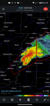
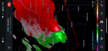
There we go. It's about to be off to the races. A lot of area for it to thrive. It's starting to work the kinks out. With well defined outflow and inflow 
Z
Zander98al
Guest

HSVweather
Member
watch out JonesboroThere we go. It's about to be off to the races. A lot of area for it to thrive. It's starting to work the kinks out. With well defined outflow and inflow View attachment 97450
Z
Zander98al
Guest
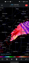
The cell cycled some, inflow and outflow size got bigger. Looks like it's strengthening heading into Jonesboro.
Z
Zander98al
Guest
Debris ball now
BufordWX
Member
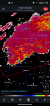
Quite a busy scene…
Z
Zander98al
Guest
Z
