• Hello, please take a minute to check out our awesome content, contributed by the wonderful members of our community. We hope you'll add your own thoughts and opinions by making a free account!

Pattern May-hem

Actually, do not "like" but it's the only signal to send, 'cept - :(:mad:
Sheettz ....
Phil

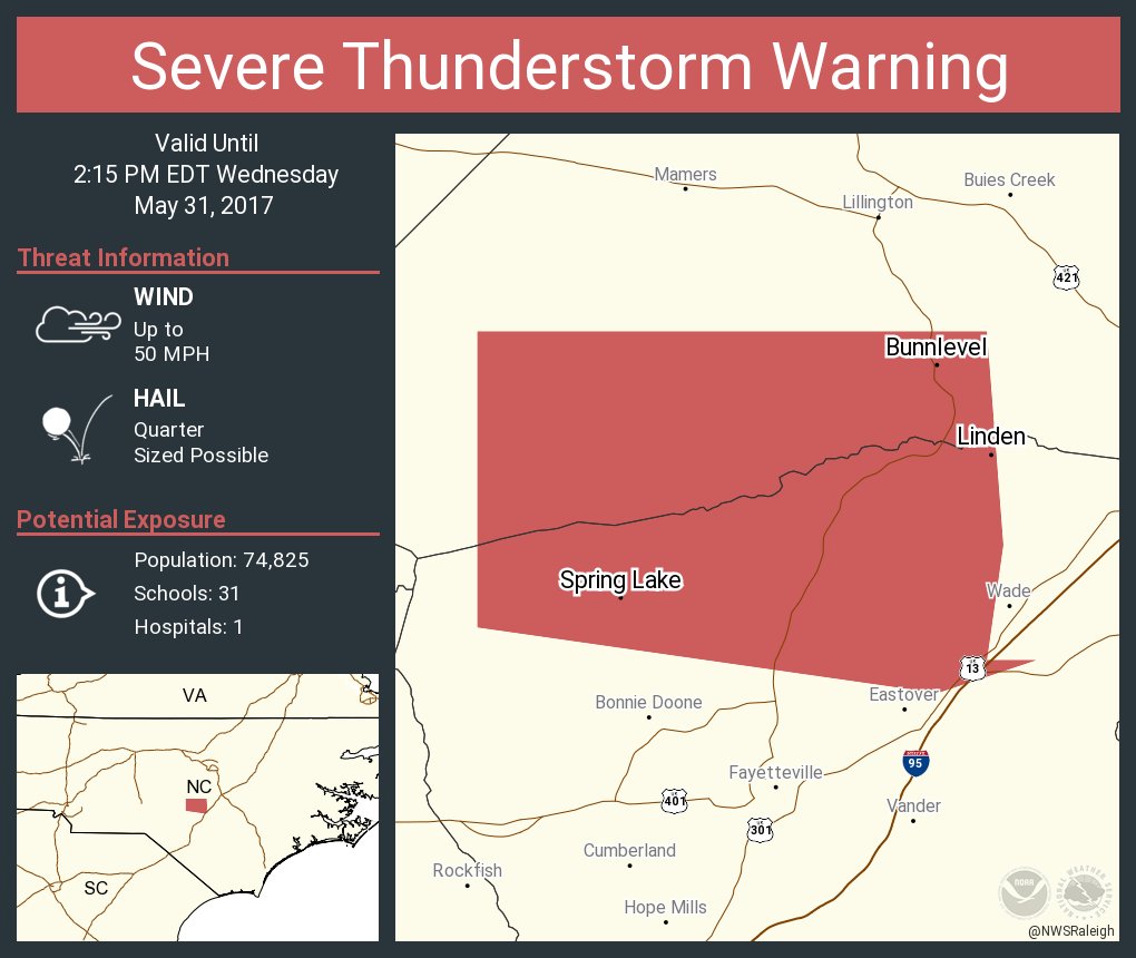
Winds were at least 50-70 miles an hr. Been a long while since I've seen winds like that. My tomato cages were FIRMLY anchored in the ground. SMH!


Sent from my iPhone using Tapatalk
 
Gotta love it when the one red blob pops up over your house
5ef4c138e39f76995ad99b412469ef34.jpg


Sent from my SM-G928V using Tapatalk
 
I guess Charlie is enjoying his vacation, because i haven't heard from him in here in a while, lol.
 
15 day GFS rain totals look great!
 
Two weeks in a row Sampson County was hit hard without any kind of warning or even a watch. Once again the storms are worse when there is no watch and nothing when there is one. Been like this the past 5 years.
 
Don't tell Brick but there is a severe t-storm warning in NC without a watch being issued
DBLBqKhW0AIZ_-2.jpg
 
I did see SPC increased the risk to marginal for most of NC today so shouldn't be surprised to see a warning or two today as noted above.... plus SBCAPE seems decent but mid level lapse rates are meh.
 
The Euro has a rain hole over the Carolinas! Hope it's wrong!
 
Outflow boundary from the earlier storms along I95 probably going to kill the storms to the west

Sent from my SM-G928V using Tapatalk
 
The Euro has a rain hole over the Carolinas! Hope it's wrong!
The GFS has a rain hole right over the upper SC and GA border area over to the GSP metro. Some areas in there only showing .25 over the next 16 days. I'm afraid the Monday storms set the tone for summer for our area. While most of us on here talk about how wet this summer is probably going to be, the 2 of us will be bone dry.
 
The GFS has a rain hole right over the upper SC and GA border area over to the GSP metro. Some areas in there only showing .25 over the next 16 days. I'm afraid the Monday storms set the tone for summer for our area. While most of us on here talk about how wet this summer is probably going to be, the 2 of us will be bone dry.
FWIW - not much showing anywhere except FL for a week or so; 2 weeks out, with a grain of salt, looks OK (not great) for most (corrected my typo, which may have been Freudian - "mist" instead of "most" ... LOL) - dadgum rain ... :oops:
 
The GFS has a rain hole right over the upper SC and GA border area over to the GSP metro. Some areas in there only showing .25 over the next 16 days. I'm afraid the Monday storms set the tone for summer for our area. While most of us on here talk about how wet this summer is probably going to be, the 2 of us will be bone dry.
We are still leaps and bounds ahead of last years disastrous summer of no rain for weeks and extreme heat. I think I heard this past drought update , had the least drought coverage since 2014, so that's awesome!
 
We are still leaps and bounds ahead of last years disastrous summer of no rain for weeks and extreme heat. I think I heard this past drought update , had the least drought coverage since 2014, so that's awesome!
Well , Roberts FB post just crushed my dreams! Heading back torwards a cool, dry NW flow pattern, with very little rain chances ! :( , especially east of apps , in Carolinas
Say he hopes its short lived , but we kick ass at drought! I guess dry and below normal temps are better than nothing! :(
 
Well , Roberts FB post just crushed my dreams! Heading back torwards a cool, dry NW flow pattern, with very little rain chances ! :( , especially east of apps , in Carolinas
Say he hopes its short lived , but we kick ass at drought! I guess dry and below normal temps are better than nothing! :(
We can do ok in a NW flow if the Lee trough gets active.

Sent from my SM-G928V using Tapatalk
 
We can do ok in a NW flow if the Lee trough gets active.

Sent from my SM-G928V using Tapatalk
That's very true from Charlotte and Columbia and east, but the GSP metro gets extremely dry in a northwest flow because of downsloping. It can also make our area the hottest in all of the southeast because of the same reason.
 
May 2017 data is not in yet, but when it is, we'll compare it to 2016 and see how we're starting out versus last year!

cd174.64.77.18.151.13.50.42.prcp.png
 
Must be just the warmer night temps with the rain because the daytime temps areally not even comparable. It has been much cooler so far from someone who is outside all day every day.
That is precisely why blanket "comparisons" in this realm can be very deceptive; very good observation! Once official data is released next month, I'll do a composite comparison using 12Z for both years (mid-day), and another using 0Z (middle of the night), and I'm betting daytime temps are far cooler this year versus last -- but data won't be available for composites for about 20 days.
 
Back
Top