-
Hello, please take a minute to check out our awesome content, contributed by the wonderful members of our community. We hope you'll add your own thoughts and opinions by making a free account!
You are using an out of date browser. It may not display this or other websites correctly.
You should upgrade or use an alternative browser.
You should upgrade or use an alternative browser.
Severe Feb 11-12 2024 Severe Threat
- Thread starter SD
- Start date


JHS
Member
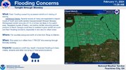
In addition to the rain, Monday afternoon and evening are looking to
have an uptick in shower and thunderstorm activity as a strong cold
front pushes eastward. A steady stream of DPVA during the period
allows for enhanced upward ascent. Bulk sfc-6km shear is pushing
80kts and instability is increasing. Latest guidance from the NAM
and GFS indicate SBCAPE amounts between 100-300 J/kg. Upper modeled
soundings from the GFS and NAM also shows a somewhat curved
hodograph from the sfc-1km and SRH values around 220 in the far
southern counties. Given the orientation of the upper shear and sfc
winds lining up mostly SW, a QLCS is not out of the picture. One
limiting factor is the amount of instability that can actually
materialize during a narrow window of max heating in the afternoon.
Cloud cover will persist through the day and evening time. So while
the model guidance has ticked upward in SBCAPE, the amount that
actually develops will have a direct impact on the convective
strength of storms forming. Additionally, guidance keeps the warm
front to the south and narrowly edges it into the CWA. Where the
front sets up will also have a direct impact on if storms can become
strong to severe. The Storm Prediction Center keeps the SW portion
of the CWA in a MRGL risk, with the SLGT just brushing against the
southern counties. Will continue to monitor.
As it stands now the GSP area would probably be a little too far north for severe, but it would not take much to change it. Get that warm front 50 miles north to go with that shear and things could get interesting.
Darklordsuperstorm
Member

Darklordsuperstorm
Member
Spann posted this in his morning update. He mentioned the stalled front being a focusing mechanism for potentially higher probabilities of updraft helicity
Darklordsuperstorm
Member
I feel bad for the CBS affiliates this evening.
3k had a lot of UH. It does seem like though the stalled front will be the area of most interest as storms form and have a tendency to move along itSpann posted this in his morning update. He mentioned the stalled front being a focusing mechanism for potentially higher probabilities of updraft helicityView attachment 146168
JHS
Member
That will probably be the case over GA and the Carolinas tomorrow too. GSP also mentions a triple point low for our area.3k had a lot of UH. It does seem like though the stalled front will be the area of most interest as storms form and have a tendency to move along it
Darklordsuperstorm
Member
SPC pull trigger on ENH

Darklordsuperstorm
Member
1st storm of the day quickly getting its act together in East Texas 

vsublazer
Member


3K NAM looks pretty active along the I-20 corridor

This for S of Vicksburg might become a problem

Brick Tamland
Member

Wow NAM laying down over 6in of rain in western GA within the next 24 hrs

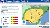
SPC AC 120555
Day 1 Convective Outlook
NWS Storm Prediction Center Norman OK
1155 PM CST Sun Feb 11 2024
Valid 121200Z - 131200Z
...THERE IS A SLIGHT RISK OF SEVERE THUNDERSTORMS ACROSS PORTIONS OF
CENTRAL/SOUTHERN AL...CENTRAL/SOUTHERN GA...SOUTHERN SC...AND THE FL
PANHANDLE...
...SUMMARY...
Scattered severe storms are forecast on Monday over parts of the
Southeast. Damaging winds and a few tornadoes will be possible.
...Southeast States into the Carolinas...
A shortwave trough is forecast to mature into a closed cyclone as it
progresses quickly northeastward from the Arklatex/East TX vicinity
through the TN Valley, continuing off the Mid-Atlantic coast early
Tuesday morning. Strong mid-level flow will accompany this system,
with 100-110 kt at 500-mb spreading across the Southeast states
during the day, eventually reaching the Carolinas late Monday.
Robust low-level flow will precede this system as well, particularly
during the evening and overnight across the Carolinas as the system
matures/deepens and becomes more vertically stacked.
Surface pattern associated with this system will be a bit more
complex, with widespread precipitation and associated outflow
strongly influencing the position of the warm front. General
expectation is for a surface low to begin the period near the
central MS/AL border vicinity, with a warm front extending
east-northeastward across central GA into southern SC. Northward
movement of this warm front during the day across the Southeast will
likely be limited by widespread precipitation north of the boundary.
In fact, there is some potential for this front to shift slowly
southward as an outflow-augmented cold front during the morning and
early afternoon.
This overall evolution may limit the spatial extent of the warm
sector during much of the day across the Southeast. Widespread cloud
cover will also restrict heating, with the cooler mid-level
temperatures/steep lapse rates remaining displaced west with the
shortwave. As a result, in contrast to the robust kinematic fields,
thermodynamic conditions are expected to remain marginal, likely
limiting overall storm depth and maturity. A predominately linear
mode is anticipated on the eastward moving cold front attendant to
the surface low, with the aforementioned thermodynamic conditions
likely limiting storm strength along the front as well. Even so, the
strong shear could still result in storm capable of producing
damaging gusts and/or a brief tornado or two. Isolated instances of
hail are possible as well.
A limited threat for damaging gusts and isolated hail will extend
northward into the Carolinas Monday evening and overnight as the
closed cyclone moves through. However, storm intensity will be
limited here as well, with scant buoyancy acting as the limiting
factor.
..Mosier/Bentley.. 02/12/2024
ForsythSnow
Moderator
Well that quickly de-escalated for the N half of the state or so. This entire system seems unpredictable and just a huge swath of heavy rain so far with the severe being limited much further south at the moment still. Convection robbing maybe?View attachment 146309
SPC AC 120555
Day 1 Convective Outlook
NWS Storm Prediction Center Norman OK
1155 PM CST Sun Feb 11 2024
Valid 121200Z - 131200Z
...THERE IS A SLIGHT RISK OF SEVERE THUNDERSTORMS ACROSS PORTIONS OF
CENTRAL/SOUTHERN AL...CENTRAL/SOUTHERN GA...SOUTHERN SC...AND THE FL
PANHANDLE...
...SUMMARY...
Scattered severe storms are forecast on Monday over parts of the
Southeast. Damaging winds and a few tornadoes will be possible.
...Southeast States into the Carolinas...
A shortwave trough is forecast to mature into a closed cyclone as it
progresses quickly northeastward from the Arklatex/East TX vicinity
through the TN Valley, continuing off the Mid-Atlantic coast early
Tuesday morning. Strong mid-level flow will accompany this system,
with 100-110 kt at 500-mb spreading across the Southeast states
during the day, eventually reaching the Carolinas late Monday.
Robust low-level flow will precede this system as well, particularly
during the evening and overnight across the Carolinas as the system
matures/deepens and becomes more vertically stacked.
Surface pattern associated with this system will be a bit more
complex, with widespread precipitation and associated outflow
strongly influencing the position of the warm front. General
expectation is for a surface low to begin the period near the
central MS/AL border vicinity, with a warm front extending
east-northeastward across central GA into southern SC. Northward
movement of this warm front during the day across the Southeast will
likely be limited by widespread precipitation north of the boundary.
In fact, there is some potential for this front to shift slowly
southward as an outflow-augmented cold front during the morning and
early afternoon.
This overall evolution may limit the spatial extent of the warm
sector during much of the day across the Southeast. Widespread cloud
cover will also restrict heating, with the cooler mid-level
temperatures/steep lapse rates remaining displaced west with the
shortwave. As a result, in contrast to the robust kinematic fields,
thermodynamic conditions are expected to remain marginal, likely
limiting overall storm depth and maturity. A predominately linear
mode is anticipated on the eastward moving cold front attendant to
the surface low, with the aforementioned thermodynamic conditions
likely limiting storm strength along the front as well. Even so, the
strong shear could still result in storm capable of producing
damaging gusts and/or a brief tornado or two. Isolated instances of
hail are possible as well.
A limited threat for damaging gusts and isolated hail will extend
northward into the Carolinas Monday evening and overnight as the
closed cyclone moves through. However, storm intensity will be
limited here as well, with scant buoyancy acting as the limiting
factor.
..Mosier/Bentley.. 02/12/2024
Quarter size hail in Birmingham right now