Webberweather53
Meteorologist
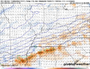
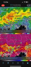
Yet another classic case of melting-induced frontogenesis near the rain-snow line over southern TN today.
Advancing low-mid level warm advection is partially offset by melting snow aloft near the rain-snow line.
This causes the local temperature gradient to increase, enhancing local frontogenesis & ascent, leading to higher snowfall rates and larger dendrites near and just to the cold side of the rain-snow line.
I've always had a soft spot for overrunning events like this for this very reason. It's hard for models to sniff out subtle warm advection aloft like this. Furthermore, the aforementioned secondary latent heating (absorption) feedbacks associated with this warm advection lead to even greater increases in precipitation &/or snowfall rates, particularly in a narrow band close to the rain-snow line. It's a beautiful thing to watch unfold in real time.
