• Hello, please take a minute to check out our awesome content, contributed by the wonderful members of our community. We hope you'll add your own thoughts and opinions by making a free account!

Washington State 11/22 - 12/1 2020

WeatherNC

Living 1-2C above 925mb
Member
2024 Supporter
Joined
Dec 31, 2017
Messages
1,562
Reaction score
4,284
Location
Greenville, NC
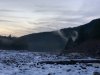
Going to share a few posts / pics / vids of our trip from RDU to SeaTac proper, Alaska Airlines direct and round trip for 216 a seat. Semi-epic, known about some of these sites since the early TWC days, for snow fall in CONUS there is no equivalent; Snowqualmie Pass, Stevens Pass and Paradise.

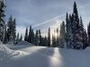
“Snoqualmie Pass as it climbs into the Cascades passes through a microclimate (humid continental)(Dfb) characterized by considerable precipitation, and at times hazardous conditions for travelers. The average annual precipitation is over 100 inches; snowfall averages over 400 inches.” !!!

534CDC2A-51D6-4A13-9309-37049834D8D0.jpgB0D72A4F-4B24-4625-B43E-35527E0D9C79.jpgB33488E9-68AC-46C5-837A-9D2ADE9D29EE.jpeg81A88527-CD7D-41A5-8E84-CD7C451144C9.jpegD680BF70-BEFC-4928-8873-60C1254E5F42.jpeg3D523317-01E1-4A29-AE77-E34741F17692.jpeg32D8A4F7-7E96-44E4-8FDA-50E1FCF36CE5.jpeg20EF7D72-B0A6-4DD3-9AB6-24F7EA8C7474.jpegB457D217-0029-43E4-9AAC-5C0C7E06D85F.jpeg81F44924-0536-448B-ACFB-79FA4B285874.jpeg
 
For those who have been out here, and those who have not, never ceases to amaze climate changes over a 20-30 mile drive on I-90 and SR-2 coming back. Real deal, temperate to sub-alpine quick and back, on the Lee side Ponderosa Pines 200’ tall, Stevens Pass is a different animal averaging 470” per year and picked up 12”+ on our punch.

Few of Leavenworth as we closed the inner loop, outer was closed with avalanche chutes loaded for the season.

BE8C560A-DDFB-4736-B5D1-1E03DA67273D.jpeg5540FB96-A32D-4258-8182-E11679BCF189.jpeg44D846F3-685D-4935-B6A5-9C448E917ED8.jpeg649889B8-9DD1-442E-BCED-9EF8D07B819A.jpeg0F6AB25F-6084-4421-A0C1-EBC48CB3E9DF.jpeg6DE9A4C1-299F-4D00-A15A-568DABD0DFE7.jpegC574F7B9-DDD0-4548-8128-CA1358C3F4F8.jpegED41548A-7504-4A24-8786-AB32513F3ACD.jpeg99BAC786-D079-4151-A629-08DF28B03149.jpeg
 
“Stevens Pass experiences a maritime-influenced alpine subarctic climate (Köppen Dsc), with short, mild, dry summers and extremely heavy winter snowfall” to the tune of 470” per year avg
 
There is a holly grail, averaging over 600” per year, Paradise WA. Jan-Feb spot check NWS for this station as Aleutian Lows are occluding in the PacNW. This is my second trip to Rainier, did not make it to Paradise last go round do to roads, this time spent 2 hours in “heaven” and 2 hours down at Longmire sunset, most views are the nisqually valley or river.

I found the weather station, reflective tape here is 15’ up for snow removal, and a Lenticular cloud.

E685B575-7D04-4015-88CE-20B3F2E7A843.jpeg4FF31C2B-2A95-43B6-87F0-7F84F4E5A7E9.jpeg1D40DEE7-7F50-4495-88EE-922B32A6F6AA.jpeg8AFB47C7-6AA3-4D46-973C-C9B1E063A3FB.jpeg180ED24F-8F7F-4E16-A9E2-9EC3367061F1.jpeg8165BE07-4767-4C9C-BF59-C9C29C3CF111.jpeg671A3C8F-9DAE-4E7A-88EC-0EB3AB59FA19.jpeg


“The National Park Service says that "Paradise is the snowiest place on Earth where snowfall is measured regularly. 1,122 inches (93.5 ft, 28.5 m) of snow fell during the winter of 1971-1972, setting a world record at the time. The minimum annual snowfall at Paradise was 266 inches in the winter of 2014-15, and the maximum snowpack was 367 inches (30.6 ft, 9.3 m) in March, 1956. No snowfall measurements were made from 1943 to 1946 as the road to Paradise was closed during World War II. The high snowfall is in spite of no month recording average highs below freezing. Under the Köppen climate classification Paradise has a subpolar oceanic climate that may also be described as subarctic or subalpine.”
 

Attachments

  • 61CBF14F-B0AA-407C-AD07-94693DA23BC6.jpeg
    61CBF14F-B0AA-407C-AD07-94693DA23BC6.jpeg
    84.3 KB · Views: 16
  • 24C037E1-18FF-4C53-AA33-6A0E323DA9BC.jpeg
    24C037E1-18FF-4C53-AA33-6A0E323DA9BC.jpeg
    101.6 KB · Views: 15
Few more of Mount Rainier, for those who know me, eyeing cloud cover and sky via ECMWF and NAM nest leading up. Cascade Red Fox sighting.

073CF205-E36C-4A64-A9EF-775FCC3683A3.jpeg42647F42-1CEF-40BC-AA76-6F68D66D846E.jpeg203F99F3-EDC3-48E1-8C62-AF851E4536F6.jpeg4BDCFEEA-6906-4E1A-8BB9-1ECE6E1783F5.jpeg1B3BA63D-97B6-46EE-A61F-10BEB7975CD2.jpeg867983B5-B2A4-4403-AD47-D07A1E9B35ED.jpegD045CAAB-D9D1-448D-ABB9-6B6D0D9ABD09.jpeg

Longmire gate closes at 5pm this time of year, everyone down.
 
Heather and Kaiden were thinking a couple more days in the city before our departure, I was thinking Peninsula, Olympic type?

Most recent example of glaciation in conus, deep lakes, big ass rainforest trees and Amazon screensaver type beaches, why not?

No ---- we captured 6 Amazon screensavers, unintended, out of ~150 in the catalog.

Lake Crescent, Ruby and Rialto Beaches, Hoh, semi legit.
 
Rialto Beach, just north of La Push and Quillayute River. Checks all boxes I am aware of, river dump with inlet, tsunami zone, creek crossings out of a rainforest with elevation, lumber as wide as big pickups stacked, bear and cougar country, no safe lagoons once the tide comes in.


64A74524-B54B-4711-8034-52399508F034.jpegDC59C797-C68A-41E5-B75E-22ED07F35756.jpegBA8E6B72-6758-4DDF-8D35-E0DCF48154DA.jpegEB77D79D-4279-4F29-8C46-40DADFF0B914.jpegB872EFA6-9E3F-459D-9642-B3FCAC9A5B0A.jpeg8E3B5C2F-735D-4957-940F-E4EE6B2BDE38.jpegB9EC9005-7AFD-427D-951F-5F6A1B77089C.jpegDF852546-EEBD-4F63-80B9-E04BAB819D8A.jpegFBDFF9BF-D5D2-4F8C-BB9C-A1BB793E9E04.jpegCADECB22-940C-43C9-84FC-143E95F4D704.jpeg
 
Back
Top