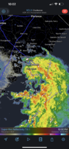
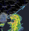
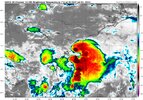
Near CHS
-
Hello, please take a minute to check out our awesome content, contributed by the wonderful members of our community. We hope you'll add your own thoughts and opinions by making a free account!
You are using an out of date browser. It may not display this or other websites correctly.
You should upgrade or use an alternative browser.
You should upgrade or use an alternative browser.
Tropical TS Colin
- Thread starter SD
- Start date
^

8pm update
1. Near the Southeastern US:
Satellite and radar images along with surface observations indicate
that a low pressure system is located along the coast of southern
South Carolina near Beaufort. Development, if any, of this system
should be slow to occur while it drifts northeastward along the
southeast U.S. coastline during the next couple of days. Regardless
of development, this system is expected to produce heavy rains,
which could cause flash flooding across portions of southeastern
Georgia and the Carolinas through tonight and into Saturday. See
products issued by the Weather Prediction Center and your local
National Weather Service forecast office for more details.
* Formation chance through 48 hours...low...20 percent.
* Formation chance through 5 days...low...20 percent
Brent
Member
Brick Tamland
Member
Glad I was at Myrtle last week and not now.
Brent
Member
Colin?
Surface observations and satellite-derived wind data indicate that
the small low pressure system located along the coast of South
Carolina is producing sustained tropical-storm-force winds
primarily to the southeast of its center over water and near the
immediate coast. In addition, shower and thunderstorm activity has
persisted near the area of low pressure over the last 6 to 12 hours.
If the associated showers and thunderstorms persist and continue to
become better organized, then this system could become a tropical
storm later today while moving northeastward along the South
Carolina coast, and then reaching the North Carolina coast by
tonight. Regardless of development, this system is expected to
produce heavy rains, which could cause flash flooding across coastal
portions of the Carolinas over the weekend. See products issued by
the Weather Prediction Center and your local National Weather
Service forecast office for more details. Further information on
the system, including offshore gale warnings, can be found in High
Seas forecasts issued by the National Weather Service.
* Formation chance through 48 hours...medium...60 percent.
* Formation chance through 5 days...medium...60 percent.
very, VERY, tropical soupy atmosphere, here on the Coast..
Hopefully, MUCH needed Rain will be had for our Farmers down here in the Coastal area(s)..
I believe either it was @Shaggy or @Downeastnc, commenting on the Corn Crops in His area(s).. It's the same down here in Horry/Brunswick/Pender & Columbus Counties.. Corn & Soy Beans are stressed & sickly looking.. Especially corn, not even reaching 5 ft & tasseling..
ALOT, of Fallow land not tilled nor planted also, because of high fuel & Fert. Prices..
I've not seen even one Bacca field planted either..
gawxnative
Member
And have Colin at 5 am
Downeastnc
Member
Well this is a let down...


Ghost
Member
I’m here now. Camping. Ocean front. Wind just kicked up middle of night. Knocked over a flag we had attached to camper. I’m out walking now. Breezy but not raining currentlyGlad I was at Myrtle last week and not now.
RollTide18
Member
Well this is random
Downeastnc
Member
shear is not helping my rain chances lol....
The best tropical storms form with little notice! Kind of line yalls food snowstorms! ???
Gotta love the llc being near or west of MYR and the precip like 4000 miles offshoreshear is not helping my rain chances lol....
LickWx
Member
Wait didn’t that happen this winter … northeast trend .Gotta love the llc being near or west of MYR and the precip like 4000 miles offshore
Shaggy
Member
Corn here is toast. No rain is gonna help it nowvery, VERY, tropical soupy atmosphere, here on the Coast..
Hopefully, MUCH needed Rain will be had for our Farmers down here in the Coastal area(s)..
I believe either it was @Shaggy or @Downeastnc, commenting on the Corn Crops in His area(s).. It's the same down here in Horry/Brunswick/Pender & Columbus Counties.. Corn & Soy Beans are stressed & sickly looking.. Especially corn, not even reaching 5 ft & tasseling..
ALOT, of Fallow land not tilled nor planted also, because of high fuel & Fert. Prices..
I've not seen even one Bacca field planted either..
Brent
Member
I like how it looks way worse now than last night before it was named ?
The NHC can't win this year so far
The NHC can't win this year so far
WXinCanton
Member
Should have never been named IMO. Setting the table to break records this season.
Brent
Member
Should have never been named IMO. Setting the table to break records this season.
It's weird because we watched Bonnie sit there for 3 days and they refused to upgrade... People have been saying they are more conservative this year but then this happens


