NWMSGuy
Member
Thought I would go ahead and get a thread started for the Severe Weather threat that is expected early next week. Not sure how many days this threat may exist so decided to cover Week 50 in its entirety.
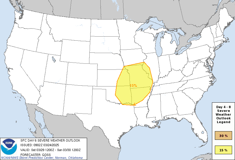
So far the Storm Prediction Center has highlighted a rare Day 7 outlook for next Monday, December 12th.
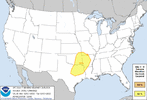
Day 4-8 Convective Outlook
NWS Storm Prediction Center Norman OK
0359 AM CST Tue Dec 06 2022
Valid 091200Z - 141200Z
...DISCUSSION...
Medium-range models over the past two runs have converged with
respect to depiction of the large-scale features -- both surface and
aloft -- through all but the very end of the period (Day 8/Tuesday
Dec. 13).
At this time, severe-weather risk appears low through Day 6, as a
relatively low-amplitude pattern early in the period gradually
amplifies, as large-scale troughing slowly evolves over the West.
It appears at this time that the result of Gulf of Alaska short-wave
troughing digging southward in broadly cyclonic western NOAM flow on
Day 5/Saturday, will be deepening of the longer-wave trough, and
eventual eastern advance of the trough across the Intermountain West
Day 6/Sunday. During this time, downstream convective potential
appears likely to remain subdued in weakly anticyclonic flow east of
the Rockies.
Day 7, models suggest that the trough begins emerging into the
Plains. As this occurs, surface cyclogenesis is expected to begin
over the central/southern High Plains vicinity, and then move across
roughly the Kansas vicinity during the evening. As this low
advances, strengthening southerly low-level flow would advect
seasonably high theta-e air northward into the evolving warm sector,
suggesting ample destabilization to support storm development as a
cold front sweeps across the southern Plains. Meanwhile, with the
low-level southerlies topped by strong southwesterly flow
accompanying the upper system, shear profiles consistent with
supercell storms are indicated.
Given this potential for severe weather indicated by both the GFS
and ECMWF, and with at least reasonable support for such evolution
evident within both ECMWF and GEFS ensembles, a 15% risk area is
being introduced for Day 7 -- centered over the Arklatex region.
Some risk could continue into Day 8, across the Tennessee and
Mid/Lower Mississippi Valleys, but this remains a bit more uncertain
at this time.
..Goss.. 12/06/2022
So far the Storm Prediction Center has highlighted a rare Day 7 outlook for next Monday, December 12th.

Day 4-8 Convective Outlook
NWS Storm Prediction Center Norman OK
0359 AM CST Tue Dec 06 2022
Valid 091200Z - 141200Z
...DISCUSSION...
Medium-range models over the past two runs have converged with
respect to depiction of the large-scale features -- both surface and
aloft -- through all but the very end of the period (Day 8/Tuesday
Dec. 13).
At this time, severe-weather risk appears low through Day 6, as a
relatively low-amplitude pattern early in the period gradually
amplifies, as large-scale troughing slowly evolves over the West.
It appears at this time that the result of Gulf of Alaska short-wave
troughing digging southward in broadly cyclonic western NOAM flow on
Day 5/Saturday, will be deepening of the longer-wave trough, and
eventual eastern advance of the trough across the Intermountain West
Day 6/Sunday. During this time, downstream convective potential
appears likely to remain subdued in weakly anticyclonic flow east of
the Rockies.
Day 7, models suggest that the trough begins emerging into the
Plains. As this occurs, surface cyclogenesis is expected to begin
over the central/southern High Plains vicinity, and then move across
roughly the Kansas vicinity during the evening. As this low
advances, strengthening southerly low-level flow would advect
seasonably high theta-e air northward into the evolving warm sector,
suggesting ample destabilization to support storm development as a
cold front sweeps across the southern Plains. Meanwhile, with the
low-level southerlies topped by strong southwesterly flow
accompanying the upper system, shear profiles consistent with
supercell storms are indicated.
Given this potential for severe weather indicated by both the GFS
and ECMWF, and with at least reasonable support for such evolution
evident within both ECMWF and GEFS ensembles, a 15% risk area is
being introduced for Day 7 -- centered over the Arklatex region.
Some risk could continue into Day 8, across the Tennessee and
Mid/Lower Mississippi Valleys, but this remains a bit more uncertain
at this time.
..Goss.. 12/06/2022

