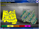
FROM NWS BMX
.SHORT TERM...
/Updated at 0230 AM CST
Sat Dec 11 2021/
Through Sunday.
Looking to our west the expected line of showers and storms is
developing as scheduled and will be moving into the area later this
morning. With a strengthening mid- and low-level
jet, a surface low
will deepen as it tracks toward the Great Lakes region, with broad
southerly
flow advecting mid to upper 60s
dew points across much of
Central Alabama. This will allow for a period of enhanced
shear and
at least weak destabilization setting up as a line of storms moves
toward and then across Central Alabama.
As the line of storms works into the area, guidance suggests a swath
of SB-
CAPE around 500-900
J/kg and 0-1 km
SRH around 300. Current
mesoanalysis shows around 800
J/kg over western Alabama right now,
so this may not be too far off. While forecast soundings suggest
storm mode should be linear,
shear vectors may allow for some breaks
or development just ahead of the line before merging. So, as this
line of storms moves in, conditions remain supportive for damaging
straight-line wind and a couple of QLCS tornadoes.
By the afternoon through 6 pm, the line of storms will move into the
Interstate 85 corridor, the environment may not be as conducive. 0-1
km
SRH falls to around 100, with 0-6 around 150 (fairly veered).
Even with the forcing lifting northeast away from the area,
instability may end up closer to 1,000
J/kg considering daytime
heating. This will allow for the line to begin break up and
transition to more discreet cells before dissipating/moving out of
the area. Would really need to
watch any boundary interaction and a
locally increases in
SRH. Therefore will parameters should still
support at least a low-end risk (conditional) for an
isolated severe
storms during this time.
Rain will linger for a few additional hours before exiting the area
by Midnight to 3 am. Behind the
front a cooler
air mass will move in
for Sunday. Sunny skies will prevail on Sunday, but temperatures
will only be in the 50s to low 60s.


