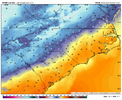
It doesn’t seem like it. Can’t even get a good CAD wedge into SC or NE Ga anymoreStep down process. We’re getting ready to cook fellas. Classic east coast winter loading View attachment 177567
-
Hello, please take a minute to check out our awesome content, contributed by the wonderful members of our community. We hope you'll add your own thoughts and opinions by making a free account!
You are using an out of date browser. It may not display this or other websites correctly.
You should upgrade or use an alternative browser.
You should upgrade or use an alternative browser.
November 2025
- Thread starter packfan98
- Start date
Just had a friend text me, said he had a rain/sleet mix @ 36 degrees. somewhere near denver NC
iGRXY
Member
Location dependent in SC. My neck of the woods still gets deep CAD wedges consistently. Eastern Greenville, northern Spartanburg, and Cherokee counties are the best at getting and holding onto wedges in SC.It doesn’t seem like it. Can’t even get a good CAD wedge into SC or NE Ga anymore
39/36 light rain
Do you know what strength of HP we had back in 2022 when the entire upstate got a good one? Was that a CAD storm?Location dependent in SC. My neck of the woods still gets deep CAD wedges consistently. Eastern Greenville, northern Spartanburg, and Cherokee counties are the best at getting and holding onto wedges in SC.
If I am not mistaken, it usually takes a HP of 1030 mb located in the Northeast for most of our winter weather storms to have a good shot at success.
My old house made it to 60 today. My new house made it to 42.Never made it out of the low 40s today here in spartanburg. pretty classic stuff. temp analysis from 1:15pm this afternoon before rain arrived in the high country, with boone running 12F warmer than mount airy
View attachment 177575
iGRXY
Member
I made it to a warm 42 for a high, but the majority of the day was around 38-39 degrees
Avg: 53.6
Highest: 78.4
Lowest: 26.6
Rain: 2”
Snow: T
Highest: 78.4
Lowest: 26.6
Rain: 2”
Snow: T
256wx
Member
34° and overcast at 10:00 in Madison, AL. Feels like winter!
Max: 77.4
Min: 21.9
Avg: 50.9
Rain: 2.38"
Snow: T
Min: 21.9
Avg: 50.9
Rain: 2.38"
Snow: T
- Joined
- Jan 5, 2017
- Messages
- 3,769
- Reaction score
- 5,966
Max: 77.4
Min: 21.9
Avg: 50.9
Rain: 2.38"
Snow: T
Similar here:
Max: 77.4
Min: 25.9
Avg: 53.4
Rain: 2.97"
Snow: ha ha ha. Yeah right.
Max 79.2
Min 21.0
Avg 52.3
Rain 1.64
Snow lol
Min 21.0
Avg 52.3
Rain 1.64
Snow lol
max 80 (on 11/22)
min 27 (on 11/29)
rain 1.31
snow supposedly pixie flakes this side of town with the big mid month ULL but i didn't see them myself
min 27 (on 11/29)
rain 1.31
snow supposedly pixie flakes this side of town with the big mid month ULL but i didn't see them myself
Max 78
Min 19
Avg 50.5
Precip 1.46
Trace of snow
Min 19
Avg 50.5
Precip 1.46
Trace of snow
Max 81
Min 21
Precip 2.16
Snow 0.2”
Min 21
Precip 2.16
Snow 0.2”

