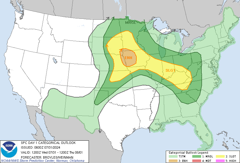
Slight risk on day 2 out for NC. More areas may be included and upgrade possible if derecho forms to our north-west.
-
Hello, please take a minute to check out our awesome content, contributed by the wonderful members of our community. We hope you'll add your own thoughts and opinions by making a free account!
You are using an out of date browser. It may not display this or other websites correctly.
You should upgrade or use an alternative browser.
You should upgrade or use an alternative browser.
Severe June 5th Severe Weather Discussion/Obs
- Thread starter BirdManDoomW
- Start date
Slight Risk now expanded southward to include Wilkesboro, Mount Airy and Boone. Marginal risk all of Charlotte NC metro. Damaging winds poss. Iso tornadoes not the main threat.
pcbjr
Member
Do we need a thread on this?
ForsythSnow
Moderator
There is actually some strong storms for the Carolinas tomorrow per the HRRR, so technically, yes. Now the cold threat wasn't, hence why it's now locked.Do we need a thread on this?
pcbjr
Member
Question answered ...There is actually some strong storms for the Carolinas tomorrow per the HRRR, so technically, yes. Now the cold threat wasn't, hence why it's now locked.
pcbjr
Member
18z NAM really favors Georgia and South Carolina too with damaging storms.
Jessy89
Member
I would be concerned with north Georgia upstate sc and western nc. Even a broken line of storms will be damaging with hail and damaging winds. I’m really concerned with the hail threat as depicted on the soundings on the Nam. I wouldn’t be surprised to see a severe thunderstorm watch issued for more areas then just western nc. Because I think further south gets some strong storms to.
Sent from my iPhone using Tapatalk
Sent from my iPhone using Tapatalk
I would be concerned with north Georgia upstate sc and western nc. Even a broken line of storms will be damaging with hail and damaging winds. I’m really concerned with the hail threat as depicted on the soundings on the Nam. I wouldn’t be surprised to see a severe thunderstorm watch issued for more areas then just western nc. Because I think further south gets some strong storms to.
Sent from my iPhone using Tapatalk
Skeptical on the hail threat, while Hail growth zones with be large tommorow, lacking mid level lapse rates, saturated soundings, freezing levels slowly lifting go against hail formation, good environment for damaging winds tho
2000 cape possible storms could contain large hail intially I think before transitioning to more of a wind threat as the day progresses. If the MCS from the north-west survives it would likely be damaging winds > hail late in the day for the central or southern mountains.
Last edited:
SPC UPDATE. Removed slight risk in the north near West Virginia and added much of North Carolina and South Carolina into a slight risk.
Raleigh NC to Columbia SC back to north-east Georgia included in SLIGHT RISK. Short term modeling favors damaging winds pushing through East Tennessee into the Carolinas.
Not sure if I agree with removing some of eastern Kentucky and south-west Virginia out of the SLIGHT but they are the experts. Short term modeling disagrees.
Also, renewed development is expected in lee of the apps. A few locations (West Jefferson, Statesville, or nearby) may be skipped over without a drop of rain per some models as severe weather develops near or EAST of i77.
B
Brick Tamland
Guest
Well, if we don't get a watch and stay in the slight risk, we might actually get a tornado threat around here today.


Drink!
ForsythSnow
Moderator
False causation is a dangerous way to think. Instead check the parameters, CAPE, and other factors. A watch doesn't cause storms to die and a lack of watches doesn't create more storms.Well, if we don't get a watch and stay in the slight risk, we might actually get a tornado threat around here today.

RepeatDrink!


