• Hello, please take a minute to check out our awesome content, contributed by the wonderful members of our community. We hope you'll add your own thoughts and opinions by making a free account!

Tropical TS Julia

Invest 91L continues to have a growing presence in the atmosphere. The GFS/CMC ensemble consensus, DSHIP, and ICON intensity and track guidance suggest it undergoes more deepening after it passes the islands in the 48-96 hour timeframe in the eastern Caribbean. Friday night into Saturday this may be a tropical storm around 70W/13.5N.
 
Last edited:
I do not expect much here in the US from 91L the movement is way too far south and even if it did trend northward we are in a pattern of constant troughs where more than likely this would get sheared and kicked away
 
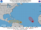
2. East of the Windward Islands:
Updated: Visible satellite images and recent satellite-derived
wind data suggest that a broad low-level circulation could be
forming in association with the tropical wave located a few hundred
miles east of the southern Windward Islands. Although the wave
is currently being affected by strong upper-level winds, conditions
could become more conducive for a tropical depression to form while
moving westward at about 15 mph, crossing the Windward Islands
tonight and early Wednesday. Conditions appear to become more
conducive for development later this week when the system reaches
the central and western Caribbean Sea. Regardless of development,
locally heavy rainfall and gusty winds are expected over portions of
the Windward Islands tonight and Wednesday. Interests in the
Windward Islands, the ABC Islands, and the northern coast of
Venezuela should monitor the progress of this system. An Air Force
Reserve Hurricane Hunter aircraft is currently enroute to
investigate this system.
* Formation chance through 48 hours...medium...40 percent.
* Formation chance through 5 days...medium...60 percent.

two_atl_5d0 (1).png
 
This could be a great ACE accumulating storm maybe if it can grab some strength before reaching land. But this pattern won’t lend you a threat to the US. 1664902631248.png
 
This could be a great ACE accumulating storm maybe if it can grab some strength before reaching land. But this pattern won’t lend you a threat to the US. View attachment 122802
This setup is also a rain killer for the SE no gulf/carribbean tap means mostly dry front after dry front
 
12z GFS.....looks like fun...all kinds of opportunity.
4 days dancing around until it splits into three....

gfs_mslpa_watl_fh132-378.gif
 
This setup is also a rain killer for the SE no gulf/carribbean tap means mostly dry front after dry front
If we can get an evolution like the CMC shows, that could bring a potential period of some good moisture transport from the gulf .. but a lot of things have to go right there so it’s still meh for rain
 
Hard to tell what's going on with 91L. Clearly a naked swirl moving WNW away from the deep storms bit looks like either a MLC or a new LLC forming over to the deep convection
 
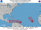
two_atl_5d0 (2).png

Updated: Visible satellite images and recent satellite-derived
wind data suggest that a broad low-level circulation could be
forming in association with the tropical wave located a few hundred
miles east of the southern Windward Islands. Although the wave
is currently being affected by strong upper-level winds, conditions
could become more conducive for a tropical depression to form while
moving westward at about 15 mph, crossing the Windward Islands
tonight and early Wednesday. Conditions appear to become more
conducive for development later this week when the system reaches
the central and western Caribbean Sea. Regardless of development,
locally heavy rainfall and gusty winds are expected over portions of
the Windward Islands tonight and Wednesday. Interests in the
Windward Islands, the ABC Islands, and the northern coast of
Venezuela should monitor the progress of this system. An Air Force
Reserve Hurricane Hunter aircraft is currently enroute to
investigate this system.
* Formation chance through 48 hours...medium...40 percent.
* Formation chance through 5 days...medium...60 percent.
 
Special Tropical Weather Outlook
NWS National Hurricane Center Miami FL
450 PM EDT Tue Oct 4 2022

For the North Atlantic...Caribbean Sea and the Gulf of Mexico:

The National Hurricane Center has initiated advisories on Tropical
Depression Twelve, located a few hundred miles west of the Cabo
Verde Islands.

1. East of the Windward Islands:
Updated: Data from an Air Force Reserve Hurricane Hunter aircraft
indicate that the broad area of low pressure located a couple of
hundred miles east of the Windward Islands does not have a closed
circulation and the center remains ill defined. In addition, the
associated shower and thunderstorm activity is still displaced to
the southeast of the center. Upper-level winds are likely to
become more conducive for development, and a tropical depression
could form during the next couple of days, if the system stays far
enough away from land while moving westward at about 15 mph across
the Windward Islands and southeastern Caribbean Sea. Conditions
are forecast to become more conducive for development later this
week when the system reaches the central and western Caribbean Sea.
Regardless of development, heavy rainfall with localized flooding,
as well as gusty winds, are expected over portions of the
Windward Islands, northern portions of South America, and the ABC
Islands during the next couple of days, and interests in those
locations should continue to monitor the progress of this system.
* Formation chance through 48 hours...medium...40 percent.
* Formation chance through 5 days...high...70 percent.
 
Yep won't effect the US but who doesn't like a good HWRF modeled IR image?

hwrf_satIR_91L_17.png
 
Back
Top