Discuss the potential impacts of TD9 once inland here
-
Hello, please take a minute to check out our awesome content, contributed by the wonderful members of our community. We hope you'll add your own thoughts and opinions by making a free account!
You are using an out of date browser. It may not display this or other websites correctly.
You should upgrade or use an alternative browser.
You should upgrade or use an alternative browser.
Tropical Ida Inland impacts
- Thread starter SD
- Start date
cd2play
Member
Gonna lead to some big ass heavy rains. But where?
Shaggy
Member
Gfs caves to the euro and no longer exits out through New England
That's a major PRE setup on the gfs for the OV and mid Atlantic. The icon went full euro with the system maintaining its identity and being absorbedGfs caves to the euro and no longer exits out through New England
tennessee storm
Member
Better hope west n mid Tennessee don’t get this tropical moisture . But most models not looking goodGonna lead to some big ass heavy rains. But where?
cd2play
Member
I’m seriously getting nervous about this. I hope it doesn’t crawl.Better hope west n mid Tennessee don’t get this tropical moisture . But most models not looking good
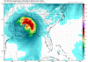
Here are the total qpfs from the gfs and icon
.png")

Camille had a max rain total of 27” in Virginia and killed over 100 there. Inland impacts are often downplayed compared to a few people seeing hurricane wind at the coast.
If the circulation stays intact similar to the icon and 0z euro there will be quite a large tornado threat with this as well
If I remember correctly Camille made an unexpected turn out of Kentucky and slammed Virginia when everyone was asleep. Euro is showing a wide arc to the right with 4-8” over the Appalachians. Global models will struggle until closer to verification but I think 6-12” is reasonable over some of the hard hit areas of TN/NC up into New England.
Z
Zander98al
Guest
Perfect position for a closed low for Alabama severe events.If the circulation stays intact similar to the icon and 0z euro there will be quite a large tornado threat with this as well
Sent from my moto g power using Tapatalk
Z
Zander98al
Guest
Again I haven't really looked at this. But I'd like to see the nadocast used in the last tropical system used for this. Elsa and that one it hit the bullseye on tornado activity.
Sent from my moto g power using Tapatalk
Sent from my moto g power using Tapatalk
Yep the gfs actually pops some SCP in AL with the center moving byPerfect position for a closed low for Alabama severe events.
Sent from my moto g power using Tapatalk
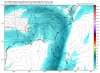
This wouldn't be good for TN and the Apps

Shaggy
Member
This wouldn't be good for TN and the Apps
View attachment 89205
Nope definitely matches what the euro showed last night.
Not good for TN. Recently had flooding rains a couple days ago.This wouldn't be good for TN and the Apps
View attachment 89205
Icon misses the trough and starts building the ridge over top it would just spin its wheels until it died or maybe eventually got drawn out by the stuff coming until the NENope definitely matches what the euro showed last night.

Shaggy
Member
Icon misses the trough and starts building the ridge over top it would just spin its wheels until it died or maybe eventually got drawn out by the stuff coming until the NEView attachment 89206
Euro will be interesting because it managed to get it back out over water. Seeing the rest of the models caving to the east exit versus out through NE gives me the sense that right now the euro is leading the pack. It may be a trend setter if it holds that solution.
Z
Zander98al
Guest
Sheesh. The ceiling is high on the tornado potential the closed low is in sync with the Jetstream. A slightly diffluent stream aloft. Gfs even tries to show streaked convection if I looked at it right. Hmm. Crazy event coming up. The turning with heights is almost at a 90° down where it's actually plotted near mobile. Which screams supercell.
Attachments
UK stalls it 