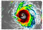
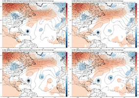
First recon plane is off and on its way!
-
Hello, please take a minute to check out our awesome content, contributed by the wonderful members of our community. We hope you'll add your own thoughts and opinions by making a free account!
You are using an out of date browser. It may not display this or other websites correctly.
You should upgrade or use an alternative browser.
You should upgrade or use an alternative browser.
Tropical Hurricane Lee
- Thread starter Metwannabe
- Start date
AL, 13, 2023090718, , BEST, 0, 166N, 507W, 105, 961, HU,
One issue I can already see from this EURO run is that it initializes the storm way too weak at 993mb. I think we can all look and agree right now that this is likely a major hurricane at this point.
Brick Tamland
Member
Really hope this stays out to sea. This is going to be a monster. I think we're seeing it becoming more and more the norm for these hurricanes to explode quickly in our current climate. Scary.
packfan98
Moderator
Too close for comfort for New England and Canada.
Tornadocane
Member
Really hope this stays out to sea. This is going to be a monster. I think we're seeing it becoming more and more the norm for these hurricanes to explode quickly in our current climate. Scary.
Agreed. I think we'll probably know by Saturday or Sunday if this truly stays out to sea. Only a few adjustments in the trough could taken Lee horrifyingly close to New England.
Too close for comfort for New England and Canada.
just yesterday he was guaranteeing it was ots ?
Tornadocane
Member
UW - CIMSS
ADVANCED DVORAK TECHNIQUE
ADT-Version 9.1
Tropical Cyclone Intensity Algorithm
----- Current Analysis -----
Date : 07 SEP 2023 Time : 191020 UTC
Lat : 16:39:35 N Lon : 50:53:23 W
CI# /Pressure/ Vmax
5.6 / 957.7mb/104.6kt
Final T# Adj T# Raw T#
5.6 5.8 6.6
Estimated radius of max. wind based on IR : 19 km
Center Temp : +18.4C Cloud Region Temp : -69.7C
Scene Type : EYE
Subtropical Adjustment : OFF
Extratropical Adjustment : OFF
Positioning Method : ARCHER POSITIONING
lexxnchloe
Member
Too close for comfort for New England and Canada.
Yes, the runs with Margot further west push Lee further west
lexxnchloe
Member
Euro 12z today another bit west of last night

last night


last night

Brent
Member
ForsythSnow
Moderator
Forecast now maxes out at 165 mph too this advisory. Have to see if the HAFS is right in 24 hours but I'm not sure a 200 mph storm will happen.Cat 4 and becoming stunning on satellite. Recon will be there in a couple hours View attachment 136900
Heelyes
Member
S
Should be some good surfing on the OBXEuro 12z today another bit west of last night

last night

Brent
Member
Forecast now maxes out at 165 mph too this advisory. Have to see if the HAFS is right in 24 hours but I'm not sure a 200 mph storm will happen.
It's definitely gonna be hard in that area. Irma topped out at 180 in a similar spot. Dorian was 185 in the Bahamas. The others were 185-190 in the Caribbean or the Gulf
Tornadocane
Member
We now have Major Hurricane Lee! Max winds 130MPH.
980
WTNT33 KNHC 072051
TCPAT3
BULLETIN
Hurricane Lee Advisory Number 10
NWS National Hurricane Center Miami FL AL132023
500 PM AST Thu Sep 07 2023
...LEE NOW A CATEGORY 4 HURRICANE...
...RIP CURRENTS AND HAZARDOUS SURF WILL SPREAD ACROSS THE NORTHERN
CARIBBEAN FRIDAY AND BEGIN AFFECTING THE MAINLAND U.S. BY SUNDAY...
SUMMARY OF 500 PM AST...2100 UTC...INFORMATION
----------------------------------------------
LOCATION...16.9N 51.3W
ABOUT 780 MI...1260 KM E OF THE NORTHERN LEEWARD ISLANDS
MAXIMUM SUSTAINED WINDS...130 MPH...215 KM/H
PRESENT MOVEMENT...WNW OR 295 DEGREES AT 15 MPH...24 KM/H
MINIMUM CENTRAL PRESSURE...953 MB...28.15 INCHES
Remnants of Chris Public Advisory
www.nhc.noaa.gov
probably still goes ots but emergency management personnel from about Connecticut-eastward have reason to be absolutely terrified; 12 foot surge going up providence bay is a real thing on the table
Brent
Member
probably still goes ots but emergency management personnel from about Connecticut-eastward have reason to be absolutely terrified; 12 foot surge going up providence bay is a real thing on the table
NHC did put this at the end of the discussion
There is uncertainty in any northward turn of Lee beginning early
next week, but it is too soon to speculate about specific potential
impacts a week or more out.
I think it turning north is a given based on modeling right now. The big question is how long will Margot block it from being able to turn east any. The EURO has it blocking off until it’s too late and we see go very close to Cape Cod and then up into Maine.NHC did put this at the end of the discussion
There is uncertainty in any northward turn of Lee beginning early
next week, but it is too soon to speculate about specific potential
impacts a week or more out.


