• Hello, please take a minute to check out our awesome content, contributed by the wonderful members of our community. We hope you'll add your own thoughts and opinions by making a free account!

Tropical Hurricane Isaias

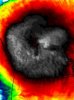
I mean damn really? This thing looks better on IR no doubt. @Webberweather53 this expansion of coldest cloud tops over to the Florida coast should this help protect it from the shear if it hangs on to the flare up?
 

Attachments

  • 20200802_122021.jpg
    20200802_122021.jpg
    553.6 KB · Views: 43
Fairly decent wind field too considering what this looked like 12 hrs ago.....just imagine what this thing would do if the shear backed off..
 
I expect 75-80mph landfall. But there’s a very slight chance of cat 2. Probably about a 10% chance but don’t underestimate that Gulf Stream!


Sent from my iPhone using Tapatalk
 
Guess this belongs here too, AFD from Blacksburg concerned with same trough and high pwats from TS for tornadoes after one occurred yesterday in Virginia. Sounds like any storms today through Tuesday will have the unusually strong August shear to work with. Supercell structures possible today based on latest cams.
 
Gonna need tornado watch soon already see hook signatures over western NC.
 
Almost a cane according to recon.....62 knt SFMR

Convection is exceptionally intense.. the LLC and MLC are still separated but despite the fairly strong shear...Isaias has exceptionally high PWATS (3"+) to counterbalance dry air intrusions, and the structure of the circulation is still fairly sound...
 
Convection is exceptionally intense.. the LLC and MLC are still separated but despite the fairly strong shear...Isaias has exceptionally high PWATS (3"+) to counterbalance dry air intrusions, and the structure of the circulation is still fairly sound...

According to this the shear is actually decreasing some around Isaias and ahead of it is even lower.
1596389617022.gif
 
Things that make you go hmmm..

starting to think a lot of NC may be surprised at the winds they see.

Fast moving system
Likely strengthening up to landfall
Barometric enhancement

sounds like a recipe for decent winds well inland.
0B372916-EF0E-4777-8DF7-7460161C5CE8.gif
 
According to this the shear is actually decreasing some around Isaias and ahead of it is even lower.
View attachment 45833

Shear seems to be an undercut because the upper levels actually look quite decent... Nice anticyclonic flow high aloft around Isaias...
In fact RECON found flight level 64kt+ Well away from the center...
recon_AF300-1909A-ISAIAS.png
 
Call me crazy but I'm not enthused by the rain chances. Its early in the tropical game and I remember dennis and floyd very well. Soaking the ground now with who knows what's to come later gives me flashbacks.

Not to mention a widespread TS wind even weakening trees for a bigger system later could also spell trouble if we get a worse system.later.

Agree. Dennis the menace wasn't bad by itself. But when Floyd came crawling along couple weeks later, it was kadibar the door. Worst flooding disaster in our state, espeacilly central and northern coastal plain. Think Dennis looped around forever off the NC coast if memory serves me correctly.
 

If the center actually comes in way down in mid SC then it may lose a lot of its punch wind wise especially on the west side by the time it gets to central NC....if the center stays over water till the SC/NC border then the bigger winds over central NC become more likely....the 12Z HWRF-para was IMO about the worst track still puts coastal SC in potential cane force winds and then the eastern half of NC gets TS/Cane force gust especially if this is a legit storm by then.
 
UK been pretty bullish. 981 entering NC, around 983 exiting.
View attachment 45839

The Ukie has been dead on that track and strength for several days now with only a few variations on it......its also bringing the pain wind wise and is easily the worst clown wind map there is.....but if this thing is somehow organized and strengthening coming in then these numbers are probably close......I feel like people are sleeping on this one and its a bad scenario setting up, weak system not really forecast to be more than a strong tropical storm but people could go to bed Mon night with a 70-75 mph storm and wake up to a 100-115 mph storm that impacts people much harder than anticipated....

latest Ukie clown map center is over Goldsboro and 982 I think in this frame....the frames before and after are similar just more north and south......basically if this is right those that get that core hit would have 10 hrs of TS force gust with the middle 5-6 hrs being cane force....this would leave half the state in the dark many for a week or more....

us_model-en-087-0_modgbr_2020080212_54_480_379.png
 
Back
Top