I’m sure Chris will do a call map, but if anyone else has call maps for portions of the SE then please post them here. I enjoy seeing them and sure many others do!
-
Hello, please take a minute to check out our awesome content, contributed by the wonderful members of our community. We hope you'll add your own thoughts and opinions by making a free account!
You are using an out of date browser. It may not display this or other websites correctly.
You should upgrade or use an alternative browser.
You should upgrade or use an alternative browser.
Wintry Call Maps for 1/16-1/18
- Thread starter Parker
- Start date
Webberweather53
Meteorologist

Webberweather53
Meteorologist
Here's Allan's map just for easier future reference...

Webberweather53
Meteorologist
WRAL.

Webberweather53
Meteorologist
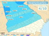
NWS RAH's first call.

Webberweather53
Meteorologist
Brad P's latest map for west-central NC. Nice to see he's at least not pedaling/regurgitating the models and/or EPS as usual at this range. He's definitely conservative to say the least.

As stated in the graphic, my confidence is low, partly because of the NAM/GFS/EURO. I tried to be more middle of the road on this map, but I'm not sure if I really achieved that. I may have been a little too bullish in some areas. Although it's on the legend, I didn't make a prediction for 2-4 inches anywhere for this map. Depending on 00z model suite tonight that could be subject to change on a final map in the morning.
Attachments
Webberweather53
Meteorologist
If things keep going like they are, these totals will be too low although I can't argue much w/ their distribution atm

Webberweather53
Meteorologist
If we continue down the path of the 0z suite, I'll have to increase these totals east of HWY 1...
WISTV:

Huffman's latest

Sent from my SM-G920V using Tapatalk

Sent from my SM-G920V using Tapatalk
Round Oak Weather
Member

ForsythSnow
Moderator
Lol I like how your map screws us over here, but seems realistic.

Webberweather53
Meteorologist
Here's my second and final map for future reference...

Round Oak Weather
Member
I think I'm gonna have to cut out the snow hole because some of the models have gone away from itLol I like how your map screws us over here, but seems realistic.
Webberweather53
Meteorologist
Don't like updating my map but the evidence strongly supports 3 to 5" in the zone of best upper divergence. Also adjusted colors so it isn't quite so horrible to the eye
View attachment 3129
Yeah I don't like updating either but given the potential involved here and how much more aggressive NWP has become in the last several suites, etc. I might have to change mine just ever so slightly by 0z tonight, plenty of evidence emerging to support a 4-8"+ event along US-1. I obviously hate doing this but at least what I put out hasn't changed much in general and I stayed on the higher end of most forecasts, anticipating changes like these to be forthcoming
I haven't had the chance but will try in a bit
I'll be posting a final call map within the hour with significant changes.
ForsythSnow
Moderator
Don't forget to put 0.1 over my area. You'll be right!I'll be posting a final call map within the hour with significant changes.
")
I'll admit, this is a very bullish forecast, but I still feel pretty good about it after catching up and looking at 12z/18z models after work today. The only thing I'm kinda questioning is if I have heavy enough totals further south into Central GA. Also I changed the 2-4 on the legend to simply 2+ inches so there's a very broad area of this on the map.
Attachments
Dont have graphics programs, but for the Central Midlands here is what I have:
"Here is what I think for my Midlands friends:
Just west or in the city of Columbia, I think a dusting is going to happen, up to an inch, if the precipitation rate works to crash the cold air down.
To the West of Columbia, Saluda through Lexington, Newberry, Greenwood, Northern Aiken, Hell, even probably the Augusta region, 1-2 inches.
To The Southern Midlands around Orangeburg, Calhoun, dusting with locally heavier banding allowing for more accumulation on colder surfaces like the grass, railways, overpasses/bridges.
Other areas to the East and South, some Wintry mix; Nothing major. This is not climo to a huge storm here."
Last edited:
Webberweather53
Meteorologist
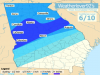
Like I said earlier I hate releasing more than 1-2 maps for an event but I can definitely make an exception here... 5"-10"+ looks solid over NWS RAH domain

Webberweather53
Meteorologist
Just gonna leave this here for future reference. These numbers too are likely too low along & west of US-1

My forecast busted hard, due to temperatures. :| We had the precipitation, imo, moreso than I thought we would have.