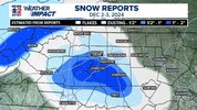
My jobsite just NW of Blairsville got a little mulch topper. The guy who stays onsite said it snowed for a lot of the night but wouldn't stick until late.
-
Hello, please take a minute to check out our awesome content, contributed by the wonderful members of our community. We hope you'll add your own thoughts and opinions by making a free account!
You are using an out of date browser. It may not display this or other websites correctly.
You should upgrade or use an alternative browser.
You should upgrade or use an alternative browser.
12/2/2024 - Potential Clipper Action!
- Thread starter packfan98
- Start date
Webberweather53
Meteorologist
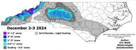
I can see why the heaviest axis of snow shifted a bit north at the last minute and kept places south of Charlotte out of it, while Greensboro got a bit more than expected.
Usually, the 2 biggest culprits of last second northward shifts in an axis of snow during winter storms that I’ve seen in the Carolinas and mid Atlantic states are warm advection and isentropic upglide. They both were present here, albeit relatively tame compared to most storms.
There was some subtle low level warm advection that developed out ahead of the mesolow. If this wasn’t sufficiently modeled (which it rarely is), it may have pushed the low level thermal gradient/boundary a bit further north.
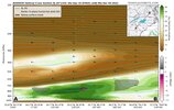
When you look at some of the vertical cross sections from the CAMs, we also had some isentropic upglide at play here above 800mb. This also likely would have helped expand the northern edge of the precip a bit to the north.
Unfortunately, wasn’t quite enough to get the RDU crowd into the mix but it was close
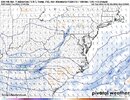


WE coulda/would of,, got more,, (Here) though the Dry Air/Low Dews, Ate much of what lil legit, precipt We had,, Low Dews & Dry air, was too much too overcome..
(South & west of Fayettnam.. )
I would been happy w/numerous flakes flying or a Flizzard,,
I'm still Happy seeing the few flakes I saw.. (Saw many but that was about it)..
Signed, Virga..
Snowless in topsail..
(South & west of Fayettnam.. )
I would been happy w/numerous flakes flying or a Flizzard,,
I'm still Happy seeing the few flakes I saw.. (Saw many but that was about it)..
Signed, Virga..
Snowless in topsail..
olhausen
Member
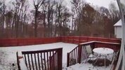
Ended up with 3/4 of an inch!
Can’t complain about that in early December. I do wonder how it correlates with the rest of winter when we get an early season snow accumulation in December. Anytime I’ve had at least a half inch or more in early December it ended up being a banger of a winter. November is a different story as I’ve had a few half inch events that ended up being the biggest snowfall of the season.
Can’t complain about that in early December. I do wonder how it correlates with the rest of winter when we get an early season snow accumulation in December. Anytime I’ve had at least a half inch or more in early December it ended up being a banger of a winter. November is a different story as I’ve had a few half inch events that ended up being the biggest snowfall of the season.


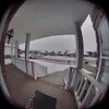
Looking at the flood light camera footage i counted 8 snowflakes
- Joined
- Jan 23, 2021
- Messages
- 4,590
- Reaction score
- 15,179
- Location
- Lebanon Township, Durham County NC
closest I could find snow to me was Burlington but there’s no obs station in Orange County anymore
I will give a dollar to anyone who can find a past storm like this approaching from the NW where the snowfall precip shield was located to the south of the 500mb vort max track. Normal rule of thumb is that the snow will be along and to the north of the 500 vort track. If wave and vort are strong, it's typically north of the track instead of along and north of the track


BHS1975
Member
Better than the last 2 years.Looking at the flood light camera footage i counted 8 snowflakes
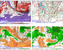
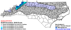
You got a vort map from December 4/5 2010?I will give a dollar to anyone who can find a past storm like this approaching from the NW where the snowfall precip shield was located to the south of the 500mb vort max track. Normal rule of thumb is that the snow will be along and to the north of the 500 vort track. If wave and vort are strong, it's typically north of the track instead of along and north of the track

Webberweather53
Meteorologist

