• Hello, please take a minute to check out our awesome content, contributed by the wonderful members of our community. We hope you'll add your own thoughts and opinions by making a free account!

Pattern NC Only Thread

The nip that has been in the air past week or two isnt as prevelant this a.m. Awesome wx looks to continue way into November. Should start picking up some rainy days mixing in.

Our leaves always peak here Halloween into first week of Nov. This year they are right on schedule. Will peak this weekend.

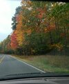
Coming down 85 Randolph Guilford line yesterday
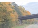
1793272195694.jpeg
 
The nip that has been in the air past week or two isnt as prevelant this a.m. Awesome wx looks to continue way into November. Should start picking up some rainy days mixing in.

Our leaves always peak here Halloween into first week of Nov. This year they are right on schedule. Will peak this weekend.

Coming down 85 Randolph Guilford line yesterday

View attachment 199190
That's a pretty noticeable change in color just in the past week. 👀
 
This is one of the longer droughts I can remember. Goes back over a year now and it's only gotten worse here. I'm seeing some ponds almost dry that I don't recall ever seeing like that
A lot of little creeks, streams, springs, and tributaries are bone dry as if they were never there before
 
Here's the 2026 Fall foliage sliding scale for NC.

North Carolina Fall Foliage Map 2026

Being well well past 50yrs old now, out of curiosity I decided to ask Gemini about the following....Certainly changed since I was growing up (and remembered) in the 1970s
~~~~~~~~~~~~~~~~~~~~~~~~~~~~~~~~~~~~~~~~~~~~~~~~~~~~~~~~~~~~~~~~~~~~~~~~~~~~~~~~~~~~~~
Q. For Raleigh specifically how much have the peak leaf color dates shifted from 1976 to 2026? Give calendar dates

For Raleigh specifically, the peak leaf color date has systematically shifted back by approximately 1 to 2 weeks over the 50-year period from 1976 to 2026.

Because peak foliage is a fluid window rather than a single calendar day, historical and current tracking records show the timing has transitioned between these specific calendar blocks:

  • In 1976 (Historical Baseline): Peak color in the central Piedmont region typically reliably arrived between October 24 and November 2.
  • In 2026 (Current Timeline): Peak color is now frequently pushed deeper into November, with the 2026 Explore Fall and regional forecasts placing Raleigh's localized peak window between November 11 and November 18.
 
This is one of the longer droughts I can remember. Goes back over a year now and it's only gotten worse here. I'm seeing some ponds almost dry that I don't recall ever seeing like that
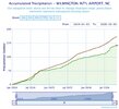
We went below average mid 2024 and has only gotten worse since. We had a good summer and made up some ground but long running drought since 2024 has us 31 inches behind over that period.chart (1).jpeg
 
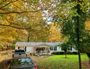
Down in Farmer NC to do some work

View attachment 199239
Farmer in Randolph County was named after either John or Fredrick Farmer who moved there in the 1700s. I love genealogy and the Farmer family of whom I am a proud descendant moved from Virginia in the 1720s when the widow of Thomas Farmer whose maiden name was Agnes Nicholson remarried and her new husband who was named John Bynum and was a Quaker took her and her children to North Carolina because Virginia did not recognize their marriage. The Farmer children who took up their stepfather's Quaker faith moved to a Quaker community in Randolph County while the others stayed in Eastern North Carolina. My branch is descended from Isaac Farmer who moved what was Edgecombe County then and later became Wilson County. Now you have had your dose of useless trivia for the day.
 
Last edited:
Never seen a hazardous material warning from the NWS until today

BULLETIN - EAS ACTIVATION REQUESTED
Hazardous Materials Warning
NC Sampson County Sampson County Emergency Services
Relayed by National Weather Service Raleigh NC
905 AM EST Sun Nov 1 2026

...Sampson County Emergency Services Hazmat Emergency...

The following message is transmitted at the request of Sampson
County Sampson County Emergency Services.

A hazardous materials emergency is occurring on US Highway 421
near Bestwood Lane. Residents... motorists... and anyone currently
within the affected area are instructed to EVACUATE IMMEDIATELY.
Move away from the incident area and follow directions from law
enforcement and emergency personnel. Do not approach the scene or
attempt to travel through the affected area. Avoid US 421 near
Bestwood Lane until further notice. Additional information and
instructions will be provided as the situation develops. Please
share this alert with others who may be in the affected area.
 
@weather bubba , I enjoy random local history on stuff like that, although I know most don't have a strong interest in it. I admit I've never heard of Farmer in Randolph. 1720's is very early for that area.
One of the Farmers I mentioned moved to Randolph County a little after 1750 and the other not long after that. The 1720s would be very early for Randolph County.
 
Gfs has been loving these 300 plus hour storms. It's gonna be a long winter of long range blizzards only to end up 45 and rain or no storm at all
 
Looking at the ops overnight for this week. Looks like their will be a narrow strip rewarding some folks. Least likely coastal and foothill regions. As well as some of us in Piedmont ( more likely Triad to miss out than Triangle ). Triangle into northern coastal plain looks to be sweet spot.

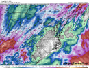
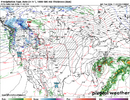
Also noticeable about 10-11 days out as the crow flies is a SE coastal Low spins up. GFS is a lot cooler and even gets some brief flakes High country up to WVA. While Euro looks like a tropical storm before pulling out. 1st time Ive seen this, could be something to watch or most likely both of them having a case of the hiccups at the same time.

1793705095166.png


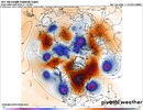
Then Euro goes full on Omega Block late November.
1793705676789.png
 
Last edited:
Looking at the ops overnight for this week. Looks like their will be a narrow strip rewarding some folks. Least likely coastal and foothill regions. As well as some of us in Piedmont ( more likely Triad to miss out than Triangle ). Triangle into northern coastal plain looks to be sweet spot.

Also noticeable about 10-11 days out as the crow flies is a SE coastal Low spins up. GFS is a lot cooler and even gets some brief flakes High country up to WVA. While Euro looks like a tropical storm before pulling out. 1st time Ive seen this, could be something to watch or most likely both of them having a case of the hiccups at the same time.

View attachment 199302


Then Euro goes full on Omega Block late November.
View attachment 199303
Gfs has floated it for a few runs but the euro jumping on board makes it a little more interesting
 
Looking at the ops overnight for this week. Looks like their will be a narrow strip rewarding some folks. Least likely coastal and foothill regions. As well as some of us in Piedmont ( more likely Triad to miss out than Triangle ). Triangle into northern coastal plain looks to be sweet spot.

Also noticeable about 10-11 days out as the crow flies is a SE coastal Low spins up. GFS is a lot cooler and even gets some brief flakes High country up to WVA. While Euro looks like a tropical storm before pulling out. 1st time Ive seen this, could be something to watch or most likely both of them having a case of the hiccups at the same time.

View attachment 199302


Then Euro goes full on Omega Block late November.
View attachment 199303
However from Gemini...and asking for mby, I got this.

Q.-There seems to be a look for precip coming inland from the coast under this block

Yes, you are seeing a very specific, real atmospheric feature on the maps. That precipitation signature creeping inland is known as an easterly wave, marine stratocumulus deck, or an onshore moisture squeeze.
While the massive Omega block forces high pressure and heavy sinking air over the center of the country, it also drives a very strong, long-fetch easterly flow around its bottom-right flank.
This specific configuration creates a unique setup for coastal and eastern North Carolina:

🚢 The "Atlantic Conveyor Belt"
Because the center of that giant high-pressure dome is positioned to our north and west, it forces the wind around it clockwise. For Cary and the coastal plain, this locks in continuous winds blowing straight off the warm Atlantic Ocean.
  • Even though the upper-level Omega ridge is trying to suppress rain, the low-level easterly wind acts as a conveyor belt, forcing shallow marine moisture directly inland.
  • When this moist air collides with the slightly higher elevation of the Piedmont (the terrain slopes up toward Cary and Raleigh), it gets physically forced upward. This topographically forces cloud cover and light, patchy rain.

🛑 Why it usually "Fails" to bring heavy rain inland
You will see the Euro and other high-resolution models routinely print out a green shield of precipitation pushing from Cape Hatteras toward the Triangle. However, it often hits an invisible wall because of the block:
  1. The Overlying Cap: Above that shallow ocean air, the air from the Omega ridge is still sinking and very dry. This creates a powerful temperature inversion—essentially a lid on the atmosphere.
  2. Drizzle vs. Downpours: Because the clouds are trapped beneath this low "lid," they cannot grow tall enough to produce heavy thunderstorms. Instead, what actually sneaks inland under this setup is usually dense, persistent overcast, patchy fog, and areas of light, misty drizzle (low-QPF events).
So while you are absolutely right that moisture is trying to sneak in through the backdoor under the block, the vertical structure of the ridge usually limits this coastal moisture to low clouds and annoying dampness rather than a true drought-busting rain event.
 
It's hard to not get excited about the rain event on Friday, the ceiling is probably 2-3 inches with a decent band of 1-1.5. The problem is I dont think it's going to be a nice wide band that just progresses across the state and it's more likely to bloom early Friday then shoot into Va so areas to the SE of the initial band are left with .0something again.
 
36 yesterday morning and high of 70, 37 this morning and high of 70..... desert 🏜 weather is great

Makes sense we'd get desert weather since we do live in a desert. Hopefully, Friday's rain delivers because this as dry of a year as I can remember (granted, I'm not that old), and it's just getting worse. I remember a pretty brutal drought around 2000 back when I was a kid that led to some intense water restrictions in Greensboro, but I was too young to remember the details.

I have to give the lawn one more mow as I assume it's done growing at this point. I am going to cut it low so the snow has a better chance at topping the grass blades this winter when we get all the SUPER EL NINO-induced mega snow storms. ⛄ ⛄ ⛄
 
Makes sense we'd get desert weather since we do live in a desert. Hopefully, Friday's rain delivers because this as dry of a year as I can remember (granted, I'm not that old), and it's just getting worse. I remember a pretty brutal drought around 2000 back when I was a kid that led to some intense water restrictions in Greensboro, but I was too young to remember the details.

I have to give the lawn one more mow as I assume it's done growing at this point. I am going to cut it low so the snow has a better chance at topping the grass blades this winter when we get all the SUPER EL NINO-induced mega snow storms. ⛄ ⛄ ⛄
It'll never stick if you cut it too short.
 
Brief Shower(s) here on the Coast today, (Topsail/Surf City).. Nothing amounting too much, less than a tenth, though, it still can Rain.. Enough too settle the dust..

current conditions..

70°

Feels like 70°
E 9 mph
Gusts 11 mph
Humidity 91%
Pressure 30.24 in
Dew Point 67°
Rain Today 0.01"
 
Brief Shower(s) here on the Coast today, (Topsail/Surf City).. Nothing amounting too much, less than a tenth, though, it still can Rain.. Enough too settle the dust..

current conditions..

70°

Feels like 70°
E 9 mph
Gusts 11 mph
Humidity 91%
Pressure 30.24 in
Dew Point 67°
Rain Today 0.01"
Trying to decide if it's November 4th or May 4th!?!
 
Back
Top