
-
Hello, please take a minute to check out our awesome content, contributed by the wonderful members of our community. We hope you'll add your own thoughts and opinions by making a free account!
You are using an out of date browser. It may not display this or other websites correctly.
You should upgrade or use an alternative browser.
You should upgrade or use an alternative browser.
Pattern Octorchber
- Thread starter SD
- Start date


- Joined
- Jan 5, 2017
- Messages
- 3,822
- Reaction score
- 6,081
It is humid as hell out there. It feels like August.
- Joined
- Jan 5, 2017
- Messages
- 3,822
- Reaction score
- 6,081
77, dewpoint of 74. Yuck
- Joined
- Jan 5, 2017
- Messages
- 3,822
- Reaction score
- 6,081
I'm very confident that it is not going to rain here tomorrow. I don't know what is going on but the modeling is now very inaccurate even 36 hours out.
JHS
Member
The GFS just needs to be shut down at this point. It's becoming useless. Forecasts are being missed left and right now, and it will only get worse. We are headed back to the 50's as far as accuracy goes.
Edit: I moved this out of the NC only thread. I'm not in NC.
Edit: I moved this out of the NC only thread. I'm not in NC.
carolinachaos
Member
October begins the best three months of the year with my birthday, Halloween, Thanksgiving and Christmas.
Same!
 10/27
10/27Sent from my iPhone using Tapatalk

D-Ray
Member
1.13 on the rain gauge in just 30 minutes
iGRXY
Member
got 3 hours of rain earlier. Been raining for a while and it’s been very heavy. I’ve got 3” already and there’s no sign this is letting up
D-Ray
Member
Up to 2.02 now
lexxnchloe
Member
There is the matter of the tropical system during this time frame, which could spread very heavy rainfall and severe weather from Coastal Texas and Louisiana before lifting/minoring out into the Northeast around the middle of the month. This system could be a true problem with precipitation amounts, with heavy moisture accumulation over 48 hours in an already wet environment along the central and eastern legs of Interstate 69 and 10. In time the small feature will get picked up by the cold front moving out of the West and Great Plains, so late in the medium range should be drier, except for a lingering instability pocket over the Great Lakes. We also need to watch the position of the subtropical jet stream, which the model guidance keeps well south of the Desert and Intermountain Regions.
I again explain why the STJ position is so important: its position will often determine a mild vs. cold DJFM (winter) season. The ridge is back over the western states after the trough and front are pushed into the High Plains and points eastward. You can actually make a case for extensive dry heat over the western states in the 11-15 and 16-20 day time frames, with the southern branch staying along an axis from Baja California Sur to the Texas Gulf Coast and then across the middle and upper Gulf Stream.If that path is not altered soon (Halloween is the benchmark), the the +PNA ridge will be positioned so that cold fronts will drop out of Canada, and southern branch energy will phase with the digging westerlies over Appalachia and the Eastern Seaboard. That would mean the evolving warm West vs. cool Central/East alignment might intensify to something positively wintry far earlier than what I and others are predicting.
I again explain why the STJ position is so important: its position will often determine a mild vs. cold DJFM (winter) season. The ridge is back over the western states after the trough and front are pushed into the High Plains and points eastward. You can actually make a case for extensive dry heat over the western states in the 11-15 and 16-20 day time frames, with the southern branch staying along an axis from Baja California Sur to the Texas Gulf Coast and then across the middle and upper Gulf Stream.If that path is not altered soon (Halloween is the benchmark), the the +PNA ridge will be positioned so that cold fronts will drop out of Canada, and southern branch energy will phase with the digging westerlies over Appalachia and the Eastern Seaboard. That would mean the evolving warm West vs. cool Central/East alignment might intensify to something positively wintry far earlier than what I and others are predicting.

I'm at 1.57 inches in the rain gauge for this event and light rain is falling at my house southeast of Lake Wheeler near Raleigh. I don't think the shower that is over my house will last much longer but I am hopeful that we might see more rain later today.
JHS
Member
Not a drop here for this event. There is no excuse for this big of a forecast miss. Someone needs to be held accountable for it.

Yeah I woke up expecting rain and a wash out. I could cut the grass right now and would have no issues.Not a drop here for this event. There is no excuse for this big of a forecast miss. Someone needs to be held accountable for it.

I agree with this thinking. The ensembles do hint at +PNA beyond 14 days. It should be noted that the seasonal guidance is entirely based on ocean temperature-derived analogs and is by no means guaranteed to verify.There is the matter of the tropical system during this time frame, which could spread very heavy rainfall and severe weather from Coastal Texas and Louisiana before lifting/minoring out into the Northeast around the middle of the month. This system could be a true problem with precipitation amounts, with heavy moisture accumulation over 48 hours in an already wet environment along the central and eastern legs of Interstate 69 and 10. In time the small feature will get picked up by the cold front moving out of the West and Great Plains, so late in the medium range should be drier, except for a lingering instability pocket over the Great Lakes. We also need to watch the position of the subtropical jet stream, which the model guidance keeps well south of the Desert and Intermountain Regions.
I again explain why the STJ position is so important: its position will often determine a mild vs. cold DJFM (winter) season. The ridge is back over the western states after the trough and front are pushed into the High Plains and points eastward. You can actually make a case for extensive dry heat over the western states in the 11-15 and 16-20 day time frames, with the southern branch staying along an axis from Baja California Sur to the Texas Gulf Coast and then across the middle and upper Gulf Stream.If that path is not altered soon (Halloween is the benchmark), the the +PNA ridge will be positioned so that cold fronts will drop out of Canada, and southern branch energy will phase with the digging westerlies over Appalachia and the Eastern Seaboard. That would mean the evolving warm West vs. cool Central/East alignment might intensify to something positively wintry far earlier than what I and others are predicting.
Not to mention that this particular El Niño is truly off the charts. So, who knows? If a predominant +PNA develops and persists, all eyes turn to the NAO. Add in Greenland blocking, and this winter becomes highly interesting.

Even areas that received rain there we're winners and losers. A friend of mine just south of Raleigh go right at 2". While I got one-third of an inch. And now we go back into a dry pattern for the next 7 days.Not a drop here for this event. There is no excuse for this big of a forecast miss. Someone needs to be held accountable for it.
JHS
Member
It's not even going to rain along I-20 either, where they were forecasting 2+ inches as late as last evening. There is nothing much on the radar as of now. What little I do so has no chance of making over here, now that we are north of that front. The bad thing about this is that I'm betting this is how things go all the way through winter and into next spring. The I-10 corridor and the gulf coast get way too much rain, while most of us get very little.Yeah I woke up expecting rain and a wash out. I could cut the grass right now and would have no issues.
JHS
Member
This El Nino isn't saving us either. We will be too far north to get the good rain with it.Even areas that received rain there we're winners and losers. A friend of mine just south of Raleigh go right at 2". While I got one-third of an inch. And now we go back into a dry pattern for the next 7 days.

SuperNET
Member
Not a drop here for this event. There is no excuse for this big of a forecast miss. Someone needs to be held accountable for it.
Maybe we find something else to do and just step away. I don't get it either on the forecasting side - just say 20% chance and be done with it - instead we have this elaborate break down of a failed forecast. Not worth my time anymore if you cant get the forecasts right. It's perfectly ok to say its not going to rain for the next 100 days - it needs to be truthful and not dramatic.

You should be held accountable for your ridiculous commentsNot a drop here for this event. There is no excuse for this big of a forecast miss. Someone needs to be held accountable for it.
JHS
Member
Jan 2000.Iv never seen more of a bust in the weather forecast in my life. Went from a flooding risk to actually seeing no rain yesterday or today. Absolutely wild.

I'm trying to imagine this board if this had happened in January.Iv never seen more of a bust in the weather forecast in my life. Went from a flooding risk to actually seeing no rain yesterday or today. Absolutely wild.
We've had the rug pulled out from under us plenty of times over the years, but this one ranks pretty high on the fail boat.
I've embraced AI, so I was interested to see its interpretation of my first big rain event living in the upslope region of Transylvania County, NC. About every three hours, I'd ask ChatGPT to interpret the latest model runs.
A week ago: Looks like it's gonna rain. Details to come.
Three days ago: Rain amounts are increasing, especially across the upslope areas of NC and SC.
Yesterday: Even ChatGPT was basically like, welp...we screwed this one.
I did receive 0.65" of rain, but almost all of it came in one burst. No training. No upslope enhancement. Just an utter fail from nearly every model outside of the Euro.
It's crazy that we're so advanced with weather technology, yet sometimes we can't even get in the same church, much less the same pew, on an event less than 24 hours away.
Every year we hope the models will latch on earlier and become more consistent. (Outside of the Euro, apparently.
 )
)And now all of us are hoping that the one thing we rely on most — the models — somehow have a difficult time understanding what this Super El Niño winter wants to become.
This winter feels loaded with potential. I just hope yesterday was a blip and that AI + the models keep getting better before the stakes get a whole lot higher this winter.
Frustrating.
But as jaded as weather people become, we always come back for the next model run.


NoSnowATL
Member
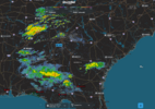
Not much, been a light rain for hrs.Radar starting to fill in. Hard to see what's coming since all of the radars on the north gulf are down.
View attachment 198430
SuperNET
Member
I'm trying to imagine this board if this had happened in January.
We've had the rug pulled out from under us plenty of times over the years, but this one ranks pretty high on the fail boat.
I've embraced AI, so I was interested to see its interpretation of my first big rain event living in the upslope region of Transylvania County, NC. About every three hours, I'd ask ChatGPT to interpret the latest model runs.
A week ago: Looks like it's gonna rain. Details to come.
Three days ago: Rain amounts are increasing, especially across the upslope areas of NC and SC.
Yesterday: Even ChatGPT was basically like, welp...we screwed this one.
I did receive 0.65" of rain, but almost all of it came in one burst. No training. No upslope enhancement. Just an utter fail from nearly every model outside of the Euro.
It's crazy that we're so advanced with weather technology, yet sometimes we can't even get in the same church, much less the same pew, on an event less than 24 hours away.
Every year we hope the models will latch on earlier and become more consistent. (Outside of the Euro, apparently.
And now all of us are hoping that the one thing we rely on most — the models — somehow have a difficult time understanding what this Super El Niño winter wants to become.
This winter feels loaded with potential. I just hope yesterday was a blip and that AI + the models keep getting better before the stakes get a whole lot higher this winter.
Frustrating.
But as jaded as weather people become, we always come back for the next model run.
A+ (maybe except this part - 'we always come back for the next model run'). I think I will find something else to do - I can get pissed off doing a lot less than that.
iGRXY
Member
Ended up at almost 5” yesterday. The boundary setup right along 85. If you were south, you got nada, north of it, flood. Landrum got over 4”. Downtown Campobello got 6”. Big winners and losers. Anderson got like a qtr of an inch while 20 minutes north in Clemson got 4” and 10 minutes north of Clemson got over 7”. Looks like more is coming through Georgia so we will see if it makes it through

Iceagewhereartthou
Member
A lot of hit and miss. I'm in easley, north of 85 and only got .28. Doesn't bother me, I'd rather it be dry fall weather and everything about to go dormant anyway but it's remarkable how big the differences are. If it were snow totals I'd be absolutely crushed.Ended up at almost 5” yesterday. The boundary setup right along 85. If you were south, you got nada, north of it, flood. Landrum got over 4”. Downtown Campobello got 6”. Big winners and losers. Anderson got like a qtr of an inch while 20 minutes north in Clemson got 4” and 10 minutes north of Clemson got over 7”. Looks like more is coming through Georgia so we will see if it makes it through
Sky86
Member
moderate rain coming down now
NoSnowATL
Member
Major bust in the Florida Panhandle. Next
JHS
Member
The radar in GA and AL looks like it should have looked yesterday, but I'm betting our CAD airmass kills most of it before it reaches too far into the Carolinas.
JHS
Member
The new EURO is nasty. Not much rain through hour 360 for a good many of us.

256wx
Member
We did not get a drop this weekend in Huntsville.The radar in GA and AL looks like it should have looked yesterday, but I'm betting our CAD airmass kills most of it before it reaches too far into the Carolinas.

I have been thinking same thing beleive it or not. Its early but you can see this pattern evolving. Everyday i flip through last frame of models and hit total qpf printout. They all in lockstep keep painting the same pic as todays 12z euro op. Cfs included out through like 700hrs.This El Nino isn't saving us either. We will be too far north to get the good rain with it.
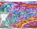
This el nino is so strong expansive that we should be seeing the stj just firehose us by now. Or at least on LR model runs. Im seeing the firehose strip/ but it is aimed way south compared to what we are use to seeing with strong el nino's. This is definitely something to keep an eye out for as we roll through october. If it looks like this in Nov still, we may miss out on the catch up rain we where expecting as a given up this way.

Carolina Fever
Member
Been a very dreary weekend. Ready for some sunny days with temps around 70.
Meanwhile, have a friend in Montana where it's 80 there today and they have a chance of snow in the forecast next Sunday.
Meanwhile, have a friend in Montana where it's 80 there today and they have a chance of snow in the forecast next Sunday.
- Joined
- Jan 5, 2017
- Messages
- 3,822
- Reaction score
- 6,081
Here we go! Raining lightly. .01" thus far. 76 degrees

I have been thinking same thing beleive it or not. Its early but you can see this pattern evolving. Everyday i flip through last frame of models and hit total qpf printout. They all in lockstep keep painting the same pic as todays 12z euro op. Cfs included out through like 700hrs.
View attachment 198433
This el nino is so strong expansive that we should be seeing the stj just firehose us by now. Or at least on LR model runs. Im seeing the firehose strip/ but it is aimed way south compared to what we are use to seeing with strong el nino's. This is definitely something to keep an eye out for as we roll through october. If it looks like this in Nov still, we may miss out on the catch up rain we where expecting as a given up this way.
Its still too early for the stj to really take over even in a strong nino unfortunately.
Yeah buddy.Here we go! Raining lightly. .01" thus far. 76 degrees
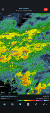
Our little friend in the Gulf : “Excessive rainfall threat ramps up once again across Central Gulf Coast and Southeast on Friday.”
We shall see … heard this one a day ago
Sent from my iPhone using Tapatalk
We shall see … heard this one a day ago

Sent from my iPhone using Tapatalk
NoSnowATL
Member
Yea 1.5in of rain here has been awful. Flooding everywhere.Our little friend in the Gulf : “Excessive rainfall threat ramps up once again across Central Gulf Coast and Southeast on Friday.”
We shall see … heard this one a day ago
Sent from my iPhone using Tapatalk