Still flurries here, sick. 18 degrees too, not sure any model had us this cold
-
Hello, please take a minute to check out our awesome content, contributed by the wonderful members of our community. We hope you'll add your own thoughts and opinions by making a free account!
You are using an out of date browser. It may not display this or other websites correctly.
You should upgrade or use an alternative browser.
You should upgrade or use an alternative browser.
Wintry Jan 23-27 Winter Storm Obs
- Thread starter Rain Cold
- Start date
Something to monitor that I am not sure if I buy quite yet is HRRR soundings staying saturated and subzero C in the low levels after the big line comes through this evening. I suppose if it’s removed from the actual front/CAA from the NW enough you could squeeze out a few more hours of -ZR
FamouslyHot
Member
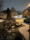
Ground is white. That’s all I need.

I said this last night. I live right by the lake and it happens too often to be a coincidence I think. It’s a massive lake. Not out of question it causes that.All night. Sometimes I wonder if the lake dissipates the moisture
Sent from my iPhone using Tapatalk

Moderate to heavy sleet now, light glaze too so some zr mixing in. But yeah, models under estimated this cold and while not out of the icy woods yet, things look better.
Well I just lost power, so there must be some ice accumulation.
- Joined
- Jan 2, 2017
- Messages
- 1,568
- Reaction score
- 4,283
Same here we are right at an inch of sleet but it's super fine..maybe snow mixing in.There’s some snow type qualities to the sleet I’m getting here. Definitely more powdery than your typical sleet. I’m about to investigate with a flashlight. It’s absolutely hammering here. Approaching an inch on the ground and 21.8/20.6.
23 degrees and everything is covered.
packfan98
Moderator
For the Triad, future radar looks like this steady precipitation will continue through around noon. Hopefully we can keep it mostly sleet. Then I imagine freezing drizzle before the heavy squall line comes through around 5:00. The NWS Raleigh mentions that most of its area can rise above freezing for a few hours. Long way to go to get there.
SimeonNC
Member
Is it safe to say that the Piedmont of NC might be out of the woods in the terms of apocalyptic ZR amounts?
I mean GSP dropped it's ZR accretion forecast so that must be mean something.
I mean GSP dropped it's ZR accretion forecast so that must be mean something.
Sitrep
rburrel2
Member
Definitely a bit of freezing rain mixing in here, but also pelting pea size sleet too. It’s a glacier out there.
- Joined
- Jan 2, 2017
- Messages
- 1,568
- Reaction score
- 4,283

packfan98
Moderator
@Webberweather53 you are going to have your work cut out for you trying to make an accumulation map.
- Joined
- Jan 2, 2017
- Messages
- 1,568
- Reaction score
- 4,283

16/14 with continued moderate pixie dust flying.... heavier returns are starting to work there way in now
packfan98
Moderator
Heavy sleet now. 16 degrees.
I think so. The local news are really stepping down on totals too.Is it safe to say that the Piedmont of NC might be out of the woods in the terms of apocalyptic ZR amounts?
I mean GSP dropped it's ZR accretion forecast so that must be mean something.
Keith Monday on channel 9 just said 1/4” or less for Charlotte proper and south.
heavy sleet here now with this leading edge
All depends how long we hold into the sleet, we still have another 8 hours of precip to goIs it safe to say that the Piedmont of NC might be out of the woods in the terms of apocalyptic ZR amounts?
I mean GSP dropped it's ZR accretion forecast so that must be mean something.
SimeonNC
Member
Also getting heavy sleet
WEATHERBOYROY
Member
Amazing temperature gradient in west Alabama! Temperature in Sulligent went from 37degrees at 4:14 to 55 degrees at 4:19 then between 4:34 and 4:54 went back down to 38 degrees! WOW!
SimeonNC
Member
I mean, I don't think we'll end up getting an inch of ZR like some of the models had.All depends how long we hold into the sleet, we still have another 8 hours of precip to go
aldamon
Member
Lot of posts said warm nose undefeated. I present to you the new (really old) champ mega-CAD.Is it safe to say that the Piedmont of NC might be out of the woods in the terms of apocalyptic ZR amounts?
I mean GSP dropped it's ZR accretion forecast so that must be mean something.
LongRanger
Member
I think a lot of y'all can forget your .75" to 1" of ice
True, the .75” amounts look to be behind us now, I was being more general that if we flip to fz rain we still can accrue dangerous levelsI mean, I don't think we'll end up getting an inch of ZR like some of the models had.
This line that comes in later today & crashes into the CAD is going to be a once in a lifetime type deal. Literally looks like a line of thunderstorms going into temperatures in the low 20s.
NWMSGuy
Member
Brief morning update, tons of Sleet has fallen locally and the Ice is starting to accumulate. I live right off Main Street here and power has jumped 3 times. Lots of power outages are starting to be reported across the area. Dangerous morning ahead. Y’all stay safe!
NEGaweather
Member
Man this cad is the real deal. Still heavy sleet and snow mixed in. Hardly no ice (great news). Can’t wait to see what happens when the line of storms slams into it later today
Sent from my iPhone using Tapatalk
Sent from my iPhone using Tapatalk
All freezing rain now
OHnoSnow
Member
Tennessee just overtook Texas for most power outages. I think Nashville might be getting hammered right now
Last edited:
WEATHERBOYROY
Member
Raleigh in SE Miss went from 66 at 5:19 to 39 at 5:59 Amazing temperature gradient!!!
NEGaweather
Member
Traffic cams in Commerce


Sent from my iPhone using Tapatalk


Sent from my iPhone using Tapatalk
Northeast Athens, Ga here... looks like 1/2" of sleet and/or snow on my porch. I don't see any ice but I haven't been outside yet. I did see something drip off my table but no icicles. Temp says 27 on wunderground. Roads in town are apparently bad. I've gotten some alerts saying don't drive.
31 and a very thin glaze on elevated surfaces here this morning, which is a bit of a surprise. According to the 0Z NAM last night, verbatim, we should be at 42F right now. Is an 11 degree bust on a 12 hour forecast bad?
6Z finally seemed to catch onto the cold hanging on longer and says we should be at 35F.
FWIW, GFS, HRRR and 3k NAM performed much better on temperatures here at the "boundary”, but nothing I’ve seen had us below freezing at the surface at this hour.
6Z finally seemed to catch onto the cold hanging on longer and says we should be at 35F.
FWIW, GFS, HRRR and 3k NAM performed much better on temperatures here at the "boundary”, but nothing I’ve seen had us below freezing at the surface at this hour.
drfranklin
Member
- Joined
- Dec 1, 2016
- Messages
- 511
- Reaction score
- 760
heavy sleet atm
south of downtown Greenville, SC
did hear tree branch crashing 10 min ago
still have power
ground is white
21 degrees
south of downtown Greenville, SC
did hear tree branch crashing 10 min ago
still have power
ground is white
21 degrees
iGRXY
Member
based on the HRRR we will get 12 more hours of precip and if the moisture is the low levels is real, we could ring out a few additional hours of light ZR or freezing drizzle even after that. It’s already mostly freezing rain here now so we will see how it accumulates
GeorgiaGirl
Member
26-28 depending on where you look.
Actually doesn’t look as if there are many power outages in the state. Some…but not much.
Actually doesn’t look as if there are many power outages in the state. Some…but not much.
NEGaweather
Member
Northeast Athens, Ga here... looks like 1/2" of sleet and/or snow on my porch. I don't see any ice but I haven't been outside yet. I did see something drip off my table but no icicles. Temp says 27 on wunderground. Roads in town are apparently bad. I've gotten some alerts saying don't drive.
Yea Commerce here and roads are bad. I’m a store manager in Hull and waiting on my team to start letting me know how it is there
Sent from my iPhone using Tapatalk
Camera just switched from BW to color, now got no icicles but freezing rain is very light.
