Dunkman
Member
One thing I know from living in central NC for 25 years is that it can always ice. I can’t count the amount of times I’ve seen that temp profiles support rain/snow and then 3 days later I’m shoveling sleet or lighting candles.
The cold that sets in after this storm after what could presumably be a major ice event for places like Columbia and Fayetteville would be the sort that kills people


What does that mean?
Considering where the google model is, I am absolutely still enthusedGlobal models notoriously underestimate CAD at this range, and overestimate the ability for cyclones to break into strong HP CAD wedges. Something to keep in mind. Not sure about AI model biases when it comes to this.

Yep, would be a classic Miller-B transfer. Can't go thru the wedge has to energy jump and usually someone gets dry slotted (with ice, not necessarily a bad thing).

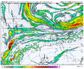
Yeah this is going to be an extremely tough forecast for models. Very complex from now through the forecast event, from complex pacific interactions to weird phasing over the southwest US to CAD once anything arrives to the southeast.This is exactly why this system is going to be once again another nightmare to predict. Below are a couple of vort maps.
GFS: Here you can see how GFS interacts with the pacific wave differently, causes the baja low to actually inhale the wave and just continue spinning in place.
Euro: Euro it does quite the opposite, that pacific wave ends up pushing the baja low into the storm. This is not at all what you want to happen at least with this system.
This is going to be a while before we figure everything out. FZR is a legit risk all across the board. However, snow remains to be determined primarily by these 2 factors.
Edit: Aware the GIF for GFS didn't go through, fixing it.
View attachment 185454View attachment 185455
This is exactly why this system is going to be once again another nightmare to predict. Below are a couple of vort maps.
GFS: Here you can see how GFS interacts with the pacific wave differently, causes the baja low to actually inhale the wave and just continue spinning in place.
Euro: Euro it does quite the opposite, that pacific wave ends up pushing the baja low into the storm. This is not at all what you want to happen at least with this system.
This is going to be a while before we figure everything out. FZR is a legit risk all across the board. However, snow remains to be determined primarily by these 2 factors.
View attachment 185455


cold dome like that is a cheat code for scoring something wintery. nikola jokic like facilitationThe thing with these sorts of setups is you really do not need the wave in the SW US to eject to get a big storm.
You just need the wave in the Desert SW to be strong enough to pump the ridge aloft over the SE US and force the mid-level flow to turn to the WSW so you can get adequate warm advection to overrun your brutally cold arctic air mass. That alone is way more than enough to get a big storm, all the while your wave is just happily milling around over AZ/NM or northern Mexico.
I can guarantee you, on the Euro verbatim, it's mostly/all sleet.Over an inch FR and close to a half of sleet, no thanks at all.
This is going to be a rollercoaster, i already know it.. If we can just keep a flatter look like GFS (Keeping that baja out) then you should have an easier time keeping it at least more south.Wow, significant increase.. some big changes at h5 too.
View attachment 185458View attachment 185459


On top of any future trends, AIFS and other AI-NWP emulators are inherently a bit oversmoothed and likely underestimating CAD.The AIFS still has some catching up to do w/ the strength of the surface high. it's been behind the curve compared to the traditional models.


On top of any future trends, AIFS and other AI-NWP emulators are inherently a bit oversmoothed and likely underestimating CAD.
Trending for a stronger and more cutoff Baja Low.Wow, significant increase.. some big changes at h5 too.
View attachment 185458View attachment 185459
Just hard to even fathom, to be honest. The EPS is printing absolutely absurd ZR totals, and we have to consider that many/most of those members are underestimating CAD still.Yep totally agree. The Euro op tends to have a problem w/ underestimating CADs.


I want no part of this. Duke power about to have a busy week watching this oneThis is one of the most absurd outputs I’ve seen from the EPS.View attachment 185468View attachment 185469
This looks like the classic old school style, models chasing the cold press, possibly all the way up to go time with that kind of AG press. Sometimes, progged TDs have to be utilized to actually capture the ceiling of just how cold/"dry" the surface airmass is to achieve the possible ceiling of how cold the air mass truly isOn top of any future trends, AIFS and other AI-NWP emulators are inherently a bit oversmoothed and likely underestimating CAD.
Just hard to even fathom, to be honest. The EPS is printing absolutely absurd ZR totals, and we have to consider that many/most of those members are underestimating CAD still.