WolfpackHomer91
Member
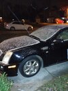
Solid Dusting In Mooresville By Downtown Off Linwood Road
Sent from my iPhone using Tapatalk


This was probably 20 min ago
Sent from my iPhone using Tapatalk
Solid Dusting In Mooresville By Downtown Off Linwood Road
Sent from my iPhone using Tapatalk
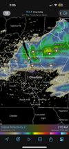
This band is packing a punch

yea I’ve refreshed radarscope about 50 times last 15 min lol. Praying we get this bad boyThis might be the closest thing to a snow squall we'll ever see down here @DopplerWx
LFG, send pics when it starts rippingFlurries has begun again, now it’s time for it to pick up !!
Are there breaks in the clouds where you are? Because for me there is and I'm not sure if that's a concerning signLFG, send pics when it starts ripping


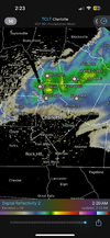
heavy returns crashing south now I think we will get in on thisJust experienced the strongest wind gust so far. This really gives the vibe of an oncoming snow squall
This event reminds me of the vort max after the mix bag winter storm back in 2022, that gave us an extra 0.5-1”. Poorly modeled, heavy but quick. This time from the NWI
heavy returns crashing south now I think we will get in on this
What town are you in?Flurries have officially started
I'm just NE of downtown, a little bit away from university, mallard creek, North lake mallWhat town are you in?
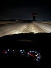
I wonder if they'll close schoolsMorning traffic is gonna be a disaster in Charlotte. Roads are turning white

Looks like the band is speeding up and thinning, forcing is moving SE quickWind keeps steadily picking up, snow is accumulating on my uncles car. Any radar updates fro?
 +PNA ftw. Always will root for a good pacific because at the end of the day, it made this event possible