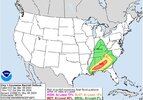
Might as well start a thread
-
Hello, please take a minute to check out our awesome content, contributed by the wonderful members of our community. We hope you'll add your own thoughts and opinions by making a free account!
You are using an out of date browser. It may not display this or other websites correctly.
You should upgrade or use an alternative browser.
You should upgrade or use an alternative browser.
Severe 3/8-9 2024 Severe Threat
- Thread starter SD
- Start date
Shaggy
Member
Wouldn't be surprised to see a north shift in the slight risk area to encompass more of NC
Maybe we'll get something worth following besides rain.
Brent
Member
Had our first tornado warning of the year in the state here
Not much else to report so far
Not much else to report so far
HRRR saying we are gonna need a boat in central AL.
FROM NWS BMX
.SHORT TERM...
(Today through Saturday)
Issued at 338 AM CST FRI MAR 8 2024
/Concern for flash flooding continues to increase tonight through
Saturday, along with a chance for severe storms across the southern
half of Central Alabama./
Radar is already starting to light up to our west early this
morning, as the potent longwave upper trough axis continues to dig
southward into the southwestern US. Upstream, southwesterly flow of
130+ knots at 300mb and 60-80 knots at 500mb will push into the mid
south region this afternoon. Ample divergence will be present aloft
as as result, and we currently have cyclogenesis occurring as we
speak in eastern Texas and northern Louisiana. As the surface low
continues moving eastward, we`ll see a warm front stretch from west
to east across southern Mississippi and southern Alabama. This front
will be a focusing mechanism for parcel lift, combined with
southerly 850mb moisture transport of 40 to 50 knots. Latest 00z
CAMs this morning are actually in decent agreement with an MCS
developing over Central Mississippi, moving rapidly eastward into
Central Alabama between noon and 3pm. The MCS and the evolution and
development of convection will strongly dictate the locations where
we may see flash flooding and will influence the amount of low-level
instability available.
According to multiple CAM solutions, the MCS would produce a cold
pool outflow boundary that will drift slowly southward through the
afternoon and evening hours near the U.S. 80/I-85 corridor. If that
solution verifies, we could see almost continuous shower and storm
development due to the cold pool boundary and stationary front
draped over the area. Rains will be very efficient due to deep low-
level moisture and PWATs increasing almost to 2 inches this
afternoon through this evening. Confidence continues to increase of
an axis of heavy rainfall of 2 to 5 inches with locally higher
amounts along and south of the I-20 corridor. WPC this morning
mentioned a potential of up to 8 inches of storm total rainfall
somewhere within this heavier axis, which is certainly not out of
the question. All locations along and south of I-20 will need to be
on alert through this event, as soils remain wet and will rapidly
respond to rainfall rates of 2-3 inches per hour. A Moderate Risk of
Excessive Rainfall is currently in place over this region, along
with a Flash Flood Watch. Heaviest rainfall is expected to finally
push eastward by Saturday morning as a trailing cold front moves
from northwest to southeast across the area.
Severe storms will also be possible with this event, but the threat
is currently very conditional. As mentioned earlier, low-level
instability is expected to be confined to our far southern counties
through the afternoon and potentially the evening hours due to the
presence of the MCS and ongoing convection/cold pool boundary. What
isn`t as clear at this point is where the surface low to our west
will move and develop through the overnight hours into Saturday
morning. If the surface low moves off to our north and west, we
could see a potential overnight for the warm sector/warm front to
lift northward with a better severe potential across our eastern and
southeastern counties tonight through Saturday morning. The HREF
ensemble mean is presenting a possibility of at least 1000-1500 J/kg
of SBCAPE available and 0-1km SRH of 150-300 between midnight and
6am Saturday. As such, the Slight Risk (2 of 5) of severe storms
remains in the forecast for roughly the southern half of Central
Alabama through 9am Saturday. Damaging winds up to 60mph and
tornadoes are the main hazards. Mesoscale conditions will be need to
be monitored throughout the event.
The cold front will move across the area during the day on Saturday,
with cooler and drier air filtering into the deep south. Behind the
front, temperatures will cool into the upper 50s to lower 60s, while
far southeast counties will warm into the low to mid 70s before the
frontal passage.
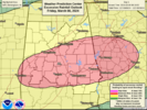

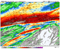
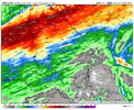
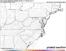
Same here both options make enough sense to not be discounted. 12z hrrr is definitely a step toward the nams vs the 6z runFascinated to see who is closer to realityView attachment 147044View attachment 147045
Most likely it will be somewhere in the middle which means that I can expect another 2-4” of rain. I’m so happy because the mud in my yard was in danger of drying up.Fascinated to see who is closer to realityView attachment 147044View attachment 147045
It will be interesting. I'm going to go clean up around the creek to avoid the flood taking anything in case that 5" does happen. Last Easter it took a 300lb picnic table down stream like it was nothing.Fascinated to see who is closer to realityView attachment 147044View attachment 147045
Models really seem to be shifting the heaviest rain axis more south here in Alabama. Looking like somewhere from Clanton to Montgomery could deal with some real flooding. The last few rain events have really lessened for my backyard the past couple of events. We may get 1-2 inches with these big shifts to the south.
JHS
Member
The NAM is hard to ignore, but I think the GFS will be closer because of CAD. Convection will keep the warm front pinned well south of us I think. The key will be if early rainfall locks in the CAD. If that does not happen the NAM may very well be right and if it is, or the middle between the 2 is right the I-85 corridor may have serious issues with flooding and the severe threat would be higher.Most likely it will be somewhere in the middle which means that I can expect another 2-4” of rain. I’m so happy because the mud in my yard was in danger of drying up.
Edit: The 12z NAM is farther south, basically giving much of the area between I-85 and I-20 in SC and GA 4+ of rain now.
Last edited:
vsublazer
Member
Yeah… I try not to ever worry about too much rain because I hate the alternative of drought, but it is starting to get a bit concerning in my area. The ground has just stayed saturated and creeks and streams have been staying swollen for a while now. I’m downstream of a dam and they have had to continually lower levels to absorb more rainfall.The NAM is hard to ignore, but I think the GFS will be closer because of CAD. Convection will keep the warm front pinned well south of us I think. The key will be if early rainfall locks in the CAD. If that does not happen the NAM may very well be right and if it is, or the middle between the 2 is right the I-85 corridor may have serious issues with flooding and the severe threat would be higher.
Edit: The 12z NAM is farther south, basically giving much of the area between I-85 and I-20 in SC and GA 4+ of rain now.
Good rain, but definitely on the lower end of the models totals here.
SnowwxAtl
Member
It seems like the storm is moving fast! Already clearing in AL!Good rain, but definitely on the lower end of the models totals here.
It's pretty much already over in Birmingham It wasn't supposed to be over until tomorrow morning.
BHS1975
Member
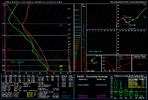
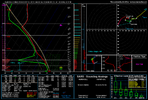
Geez some of these 12z hrrr soundings for this eveningView attachment 147053
Sent from my iPhone using Tapatalk
Seems we would need some major clearing from all the rain this morning for any severe threat.Geez some of these 12z hrrr soundings for this eveningView attachment 147053
Still pouring rain here. WRAL said it was supposed to let up around 11:00. Yeah, don't think so. I don't think we have to worry about any storms this afternoon.
ENCSnowdawg
Member
So guess this one turned into a dud.
MichaelJ
Member
Just like the winter, spring will be a dudSo guess this one turned into a dud.
tennessee storm
Member
Yeah. East side apps I agreeJust like the winter, spring will be a dud
If the pattern is similar to 2020 with the El Niño transitioning to La Niña we could be very active east of the Apps with severe weather setting up on wedge boundaries.Yeah. East side apps I agree

