NBAcentel
Member
Yea, considering it’s April or going to be when this happens. Token flakes would be a win. The amazing thing here around mby is. We still have a lot of brown grass. Usually the grass is a lot greener by now.I feel pretty decent here in the upstate. 1% chance of seeing snow. I think I’m in the “boom or bust” zone and I ain’t mad. Cold drizzle or heavy wet non accumulating snow. Can’t really complain
Somebody post that euro when it drops thx


Let’s get it inside 30 hours. We need to see the whites in her eyes. We’re one hot fart away for a full blown rain stormOKAY GFS WHIFFS BUT FV3 is on board ... CAN SOMEONE FIRE UP THIS THREAD
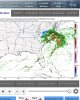
We’ve been NAM’d near truncation, that’s usually a death sentenceWOW 3km NAM delivers! Looks similar to those big runs on the EURO EPS

No, I am worried more about warm and dry. I believe going OTS is more of a possibility than a cold rain.Let’s get it inside 30 hours. We need to see the whites in her eyes. We’re one hot fart away for a full blown rain storm
Haha very true ... well someone’s going to have to pull the trigger on it .. it’s in TWO days need some earning ahead of time with it hitting in the morning/afternoonWe’ve been NAM’d near truncation, that’s usually a death sentence
But you’re also right we have like 8 or so more Nam runsHaha very true ... well someone’s going to have to pull the trigger on it .. it’s in TWO days need some earning ahead of time with it hitting in the morning/afternoon


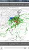
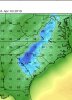
Well, I knew somebody would post it eventually...if we do get snow, this may be a little problem, but I’ve seen ground temps quite close to this before then heavy rates completely cover the ground like nothing, especially heavy wet snow, anyways this could still be a cold rainstorm
View attachment 18202
Well, I knew somebody would post it eventually...
Slight problem but temps will be in the 30s tonight and tomorrow night so that should help cool them off a little plus with the rates the 3km Nam was showing especially in upstate SC and around Charlotte .. there were quite some heavy snow bands some pinks even showing up .. won’t be a problem at all to stick. But the day after it’ll be go eI mean it is a little problem
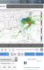
IM SOLIDLY IN THE BLUE BUT RIGHT IN THE BUT NEAR THE RAIN SNOW LINE WHICH MEANS HEAVYYYYY RATES BABY ...OH GOOD GRACIOUS IF I DONT GET THIS IM MOVING TO MILWAKEE
Rates will overcome!I mean it is a little problem

Looking better for the I-85 corridor. Keep it coming this way and we could see a good hit.
It very well is. I think it'll come NW just a bit more and the I-85 corridor will come more into play as the models are still adjusting and they seem to do that. The Kuchera puts some 6" totals down in SC and the soundings even for N GA line up for snow. In addition, the frontogenesis creating the deformation band is moving closer and starting further west this run.We are threading a very thin needle with this storm and it looks like it could possibly work out !! I’m a bit shocked we had to wait this long and I was really not taking this threat seriously but obviously that can’t be the case nomore


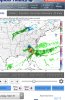
Old vs new run for 10am


Sent from my iPhone using Tapatalk
Yea the sim radar give a much more accurate depiction of reality.Old vs new run for 10am
Sent from my iPhone using Tapatalk


.png")

