accu35
Member
- Joined
- Jan 5, 2017
- Messages
- 8,278
- Reaction score
- 9,645
lol, left hookGfs around same area as 18z with that sharp right hook.
lol, left hookGfs around same area as 18z with that sharp right hook.
I agree.A faster system gives credence to a weaker system . Hell, it's not like there is a lot of time left
Sent from my SM-J327VPP using Tapatalk
A faster system gives credence to a weaker system . Hell, it's not like there is a lot of time left
Sent from my SM-J327VPP using Tapatalk
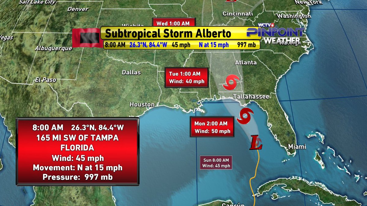
How to find the satellite images for this storm?
0z Euro is way east basically onshore tomorrow night in the Florida big bend
And much weaker
A massive win ? It had this thing east of Florida for like 5 days in a row . And it's only been correcting east after moving towards a euro trackMakes sense east=weaker cooler water and less time
This is a massive win for the gfs to start the season too

3-4 inches of rain with wind gusts in the 30mph range . How is that downplaying when it's an extremely weak systemThe Florida panhandle into eastern Alabama and western Georgia…4
to 8 inches, isolated 12 inches.
https://www.alabamawx.com/?p=162393
FFC seems to be downplaying this, per usual. Do not understand their thinking??? Any thoughts?

It isn't. It would have to be a 65 mph storm at landfall and would have to intensify a lot today. Latest path seems to put the outer bands over N GA, so severe weather is what I would be looking for. I think the max on this is 55 mph at this point.3-4 inches of rain with wind gusts in the 30mph range . How is that downplaying when it's an extremely weak system
Sent from my SM-J327VPP using Tapatalk