• Hello, please take a minute to check out our awesome content, contributed by the wonderful members of our community. We hope you'll add your own thoughts and opinions by making a free account!

Severe Severe Threat 4-13/14

Hmmmm noticing Temps and DP are pretty high south of the boundry... From ABC 3340 stream ..showed Jasper at 78/69.. pretty juicy
 
80 degrees here with a hot sun shining down. Clouds come and go and it's really windy, but first really warm day making me wish I had a pool! The rain seems very slow to get here.
 
Going out on a limb here, but folks in South Central GA need to keep a keen eye on this one ... Americus. Albany, Thomasville, Columbus ... :(
 
Looks to me like the local Birmingham NWS was right from the get go with a slight risk. Very little severe weather and no damage reports in Alabama other than a tree or two down. That’s a good thing, but the enhanced risk did not verify IMO.
 
Not sure this will be much of a severe threat when it gets here tomorrow. Alabama seems to be the place to be for severe weather in the country the last few years.
 
Not sure this will be much of a severe threat when it gets here tomorrow. Alabama seems to be the place to be for severe weather in the country the last few years.
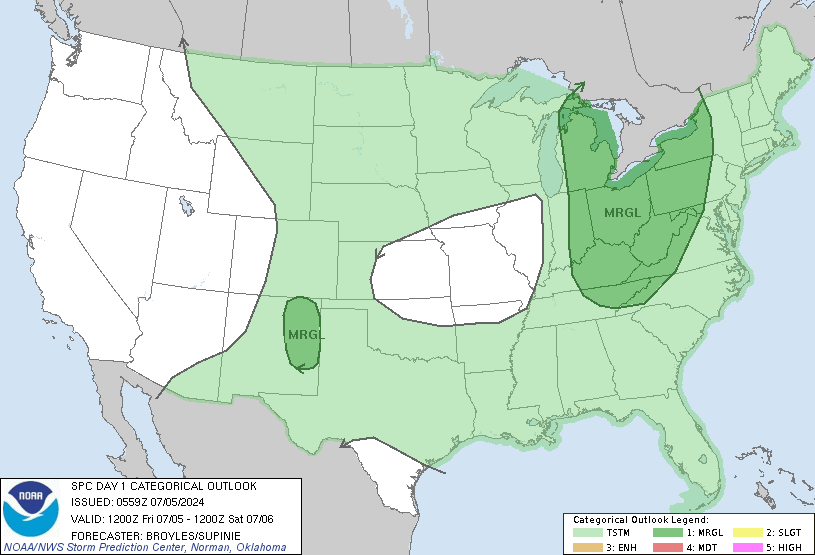
Meh. Wind threat is solid want to wait and see what's going on in the morning before jumping onto anything else

Sent from my SM-G955U using Tapatalk
 
Hope my daughter can get her soccer game in tomorrow. Suppose to play at 3.
 
FFC thinks that there is a possibility of snow flurries tommorow night.
Behind the front, we will have abnormally cold temps advecting in
and will need to monitor some light rain to snow/flurry
transition possible early Monday in the far NE mtns. Thermal
profiles indicate very shallow saturation layer so not expecting
accumulations. Also will likely have some freeze/frost concerns
that forecast updates may need to include a Freeze Watch for on
Monday morning.
 
Little concerned about the 3k developing a secondary/mesolow in NC tomorrow

Sent from my SM-G955U using Tapatalk
 
I'll be watching for a squall line progged to move through here near 2-5 PM with the potential of severe. Not looking forward to severe threat, of course, but hoping to get at least 1/2" of very badly needed rainfall. KSAV hasn't received 1/2"+ of rainfall on any one day since way back on 2/9!

Edit: 4/14 YTD rainfall at KSAV of only 4.33" is the lowest since way back in 1938!

The Heritage golf tourney at Hilton Head is starting the 4th round very early and is going in threesomes rather than twosomes on both hole 1 & 10 simultaneously to try to finish the round prior to the rain.
 
Last edited:
Already got over 7 inches of rain in places in my county. Streets are closed due to flooded. Water rescue are out
 
Getting a bit scary for us here in the foothills and western Piedmont
day1otlk_1200.gif
 
Interesting how almost all models seem to break the line up right before it gets to Wake Co. with the split in the action going right through Wake.
 
Back
Top