• Hello, please take a minute to check out our awesome content, contributed by the wonderful members of our community. We hope you'll add your own thoughts and opinions by making a free account!

Wintry Palm Sunday NC and VA Winter Storm

Does the GFS map account for sleet because RAH said sleet would be the likely precip type instead of snow.
I'm not sure. The clown maps shouldn't be taken at face value, EVER. Here is the highest snow depth map I could find. Pretty impressive. This storm looks to be similar to the one last week where there could be some very high rates. Anyone who flips to snow for an hour or two could cash in pretty big as Webb was mentioning. Freezing surface temps not needed in this case.
snod.us_ma.png
 
What do you think about this system, Jon? Pretty unique trajectory for sure. It seems to me it will be an I-40 north storm. Any chance you could post the EPS grid for Greensboro if you have time?
 
Comparing the 12z gfs to the new 18z, the surface temps are about 3 degrees colder during the heavy moisture for the I-40 corridor. Now it's 33-34 degrees. Still time to trend either direction at this point. There's going to be a super sharp cutoff somewhere it seems.
 
What do you think about this system, Jon? Pretty unique trajectory for sure. It seems to me it will be an I-40 north storm. Any chance you could post the EPS grid for Greensboro if you have time?

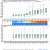
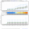
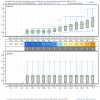
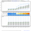
Here's what the 12z EPS looks like for Charlotte, Greensboro, Raleigh (NWS WFO), & Mt Airy (near Big Frosty).
index5.php.png
index4.php.png
index3.php.png
index.php.png
 
Comparing the 12z gfs to the new 18z, the surface temps are about 3 degrees colder during the heavy moisture for the I-40 corridor. Now it's 33-34 degrees. Still time to trend either direction at this point. There's going to be a super sharp cutoff somewhere it seems.

Yeah taken at face value this is snow north of US-64 towards the Triad, likely a wintry mix of snow/sleet/rain near RDU w/ 850s around 0 to +1C and surface temps ~34F
 
Yeah taken at face value this is snow north of US-64 towards the Triad, likely a wintry mix of snow/sleet/rain near RDU w/ 850s around 0 to +1C and surface temps ~34F
Thanks. I'm north of 64 but south of 85. Always living on the edge! I keep thinking I'm going to move to northern Guilford or Forsyth county when I retire. North of I-40 will increase my yearly snowfall 1-2 inches. Less mixing! I hate getting mixed precip when everyone north of I-40 stays snow!
 
Thanks. I'm north of 64 but south of 85. Always living on the edge! I keep thinking I'm going to move to northern Guilford or Forsyth county when I retire. North of I-40 will increase my yearly snowfall 1-2 inches. Less mixing! I hate getting mixed precip when everyone north of I-40 stays snow!

I've thought about moving to a colder place myself haha. Your snowfall climo is better than mine in central Wake, ours is a little worse than Asheboro and Siler City if that puts things into perspective ;/
 
I think after 2 or 3 0z/12z more suites we will know if this is mainly a VA or NC threat or both east of the mountains. Thereafter it will come down to exactly where the elongated frontogenetical band of intense precip sets up which determines the amount of dynamical cooling we see and the intensity of the CAD dome both of which are very hard for the models to pin down more than 24 hours out (if at all). We at least have the diurnal cycle going for us, getting the heaviest precip between midnight and sunrise as currently progged is optimal and is a baby step in the right direction of getting snow/sleet for many on the board. Regardless it’s nice to see the forum so active once again for what will probably be the last time this winter unless Apr pulls a huge rabbit out of the hat.

Oh the irony in this statement lol, the GFS is trying to introduce some freezing drizzle/sleet for NE GA and NW South Carolina by day 4 as this mammoth CAD sets in behind our storm on Saturday night into Sunday.
gfs_mslp_pcpn_frzn_seus_15.png
 
Oh the irony in this statement lol, the GFS is trying to introduce some freezing drizzle/sleet for NE GA and NW South Carolina by day 4 as this mammoth CAD sets in behind our storm on Saturday night into Sunday.
View attachment 4734
Throwing us in the mixture maybe? With a wedge that powerful, seems like a possibility for some icing here.
 
Throwing us in the mixture maybe? With a wedge that powerful, seems like a possibility for some icing here.

I wouldn't be surprised if you're below 32F w/ this kind of CAD wedge there's patchy freezing drizzle hanging around. I still think it's unreal how the cold air associated w/ this CAD dome might spill all the way to the Mississippi river and/or Memphis. This is insane.
gfs_T2m_seus_19.png
 
What do you think about this system, Jon? Pretty unique trajectory for sure. It seems to me it will be an I-40 north storm. Any chance you could post the EPS grid for Greensboro if you have time?

1b2cbb194acbf01eab62e14f1eec80f5.jpg


I agree. Northern NC VA border counties are the hot spot. I’m not completely sold on the QPF or track at this point and until the Euro stops the southern trend in QPF distribution I’m not sure what to think. Never mind P-type issues. This is a tough one and will likely go down to the wire...this forecast will be made using hires soundings because these modeled snowfall outputs are garbage.
 
Thanks. I'm north of 64 but south of 85. Always living on the edge! I keep thinking I'm going to move to northern Guilford or Forsyth county when I retire. North of I-40 will increase my yearly snowfall 1-2 inches. Less mixing! I hate getting mixed precip when everyone north of I-40 stays snow!
It is amazing how sharp the snow line is even within Forsyth County and those west. Many many times I have seen South Winston get 1-3 inches and Rural Hall, extreme northern Forsyth areas get 3-6 with the same storm, a distance of 20 miles or so at most
 
I wouldn't be surprised if you're below 32F w/ this kind of CAD wedge there's patchy freezing drizzle hanging around. I still think it's unreal how the cold air associated w/ this CAD dome might spill all the way to the Mississippi river and/or Memphis. This is insane.
View attachment 4735
Seems so strong that the 925 layer is well below freezing, and would be enough for some sleet. A good March sleetstorm would make this winter I'd say.
 
Oh the irony in this statement lol, the GFS is trying to introduce some freezing drizzle/sleet for NE GA and NW South Carolina by day 4 as this mammoth CAD sets in behind our storm on Saturday night into Sunday.
View attachment 4734
So the wedge is gonna last from Sat-Tues? Or is Tuesday a new wedge?
 
It is amazing how sharp the snow line is even within Forsyth County and those west. Many many times I have seen South Winston get 1-3 inches and Rural Hall, extreme northern Forsyth areas get 3-6 with the same storm, a distance of 20 miles or so at most
Those are the type of storms where I get 1/2" to an inch of slop in NW Randolph County.
 
If you wanted to see a stupid strong CAD dome, well you got it in the medium range. Think about the amount of easterly flow that the juxtaposition of this monster cold surface high in New England plus the combination of this "bomb" cyclone offshore will generate and pile mass like there's no tomorrow against the Appalachian mountains. The along barrier pressure gradient force is going to be mind-boggling as a result thus areas not accustomed to seeing sensible impacts from a CAD like north-central FL, Alabama, Tennessee, and Mississippi could get involved here. Even if you just like cold/snow, you have to appreciate the dynamics involved in extreme weather patterns like this.
namconus_mslpaNorm_eus_53.png
 
If you wanted to see a stupid strong CAD dome, well you got it in the medium range. Think about the amount of easterly flow that the juxtaposition of this monster cold surface high in New England plus the combination of this "bomb" cyclone offshore will generate and pile mass like there's no tomorrow against the Appalachian mountains. The along barrier pressure gradient force is going to be mind-boggling as a result thus areas not accustomed to seeing sensible impacts from a CAD like north-central FL, Alabama, Tennessee, and Mississippi could get involved here. Even if you just like cold/snow, you have to appreciate the dynamics involved in extreme weather patterns like this.
View attachment 4737
In addition, I wonder if the snow up in NC will fuel the cold areas downstream Monday if it lasts, which I'd guess it could given the cold temps and constant cloudcover. Insane seeing a 1047 high plus that bomb.
 
Back
Top