• Hello, please take a minute to check out our awesome content, contributed by the wonderful members of our community. We hope you'll add your own thoughts and opinions by making a free account!

Severe Harvey Severe Weather Threat (Aug 31 - Sep 1)

Not a bad call on the wedge boundary..... I got to say, I am getting a little nervous about the possibilities for tomorrow. A lot of folks will be watching the radar closely.
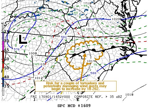
Kendra Kent on WHNS seems to think that boundary will be farther south. She is thinking that the greatest threat exists from near Spartanburg and northern Union county in SC up to near the Hickory NC area. And then of course on to the east of this area in both states.
 
Hoping for a way to avoid rain friday pm, evening to salvage HS football. Need the wedge boundary to get down near state line.

Thats a nasty line moving through Alabama.
 
NAM doesn't bring a lot of confidence on the wedge front. Kinda stalls around i40 before going back north. The 3k is toward the 74 nc/sc border. The sref plume reflect the uncertainty with dews from 61-74

Sent from my SM-G955U using Tapatalk
 
Drove through one of the most ridiculous downpours I've ever driven in, if not "THE" most ridiculous this afternoon on my way home.
 
Raining here this morning. Unless it clears up, I don't see much around here as far as storms go. We usually need some clearing to create the spark.
 
NAM doesn't bring a lot of confidence on the wedge front. Kinda stalls around i40 before going back north. The 3k is toward the 74 nc/sc border. The sref plume reflect the uncertainty with dews from 61-74

Sent from my SM-G955U using Tapatalk
Seems that front is not making a lot of progress this morning, not sure how far south it gets.....
 
HC4tbzwQSkKHN_j-ktBeRA.png
 
Sun is out here! Getting juicy! Took the tornado wording out of my local forecast , replaced with damaging winds possible. Are there supposed to be supercellular or linear? After the line moving through ATL is past me, is that it?
 
Starting to clear in Raleigh. Wonder if it's enough to fire thing up today or if all the action will be in the sandhills.
 
Oh man those storms back toward CLT are popping

Sent from my SM-G955U using Tapatalk
 
Tornado Watch Number 477
NWS Storm Prediction Center Norman OK
150 PM EDT Fri Sep 1 2017

The NWS Storm Prediction Center has issued a

* Tornado Watch for portions of
Western and central North Carolina
Northern South Carolina

* Effective this Friday afternoon and evening from 150 PM until
1000 PM EDT.

* Primary threats include...
A few tornadoes likely
Isolated damaging wind gusts to 70 mph possible

SUMMARY...Thunderstorms are beginning to develop in broken bands to the east of the remnants of tropical depression Harvey. These storms will strengthen through the afternoon, and the storm environment will favor a threat for tornadic supercells along a slow-moving front across North Carolina through late evening.

The tornado watch area is approximately along and 45 statute miles north and south of a line from 30 miles southwest of Hickory NC to 55 miles east northeast of Fayetteville NC.
 
Back
Top