• Hello, please take a minute to check out our awesome content, contributed by the wonderful members of our community. We hope you'll add your own thoughts and opinions by making a free account!

Pattern ENSO Updates

Meanwhile, the latest weekly 3.4 cooled slightly from -0.9 to -1.0, the coolest in 2 months.

Surprisingly, 3.4 cooled slightly again and is now down to -1.1, which is tied for the coldest weekly, which was last set in the fall. So, based on this, we're still in moderate La Nina territory.
 
Last edited:
In today's weekly update, 3.4 warmed from -1.1 to -0.8.
 
Oh snap! I just saw an ENSO update from the Australian Bureau and the La Nina has already ended! That was QUICK! I didn't expect it to end THIS fast! I thought it would be later on in spring, but I guess not haha. Amazing how the MJO, Kelvin Wave, and WWB literally obliterated this La Nina in a matter of weeks when it was just at moderate levels! @GaWx @Webberweather53
 
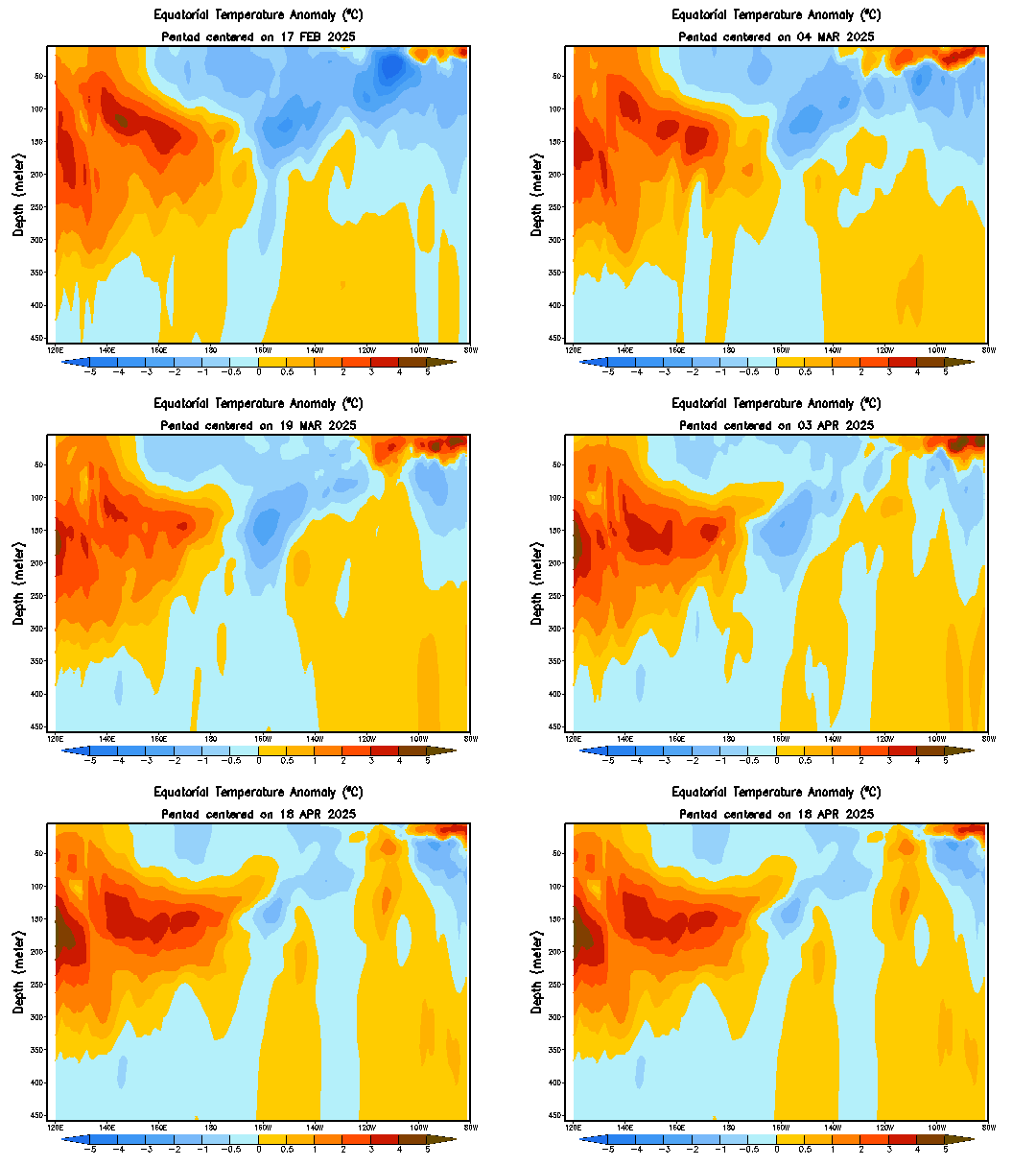
The downwelling oceanic Kelvin wave that was generated by the big MJO burst in February has entered the eastern Pacific and a slackening of the trades the next few weeks due to the MJO propagating into the WP and W Hem should aid in its continued maintenance and/or growth when it reaches the eastern boundary region in a 2-3 weeks or so. This La Nina will come to a screeching halt in short order.
wkxzteq_anm.gif
 
Here comes downwelling kelvin wave #2 in the CP (between about 180-160W) triggered by week after week of near surface anomalous westerlies and convergence around and just west of the dateline. We're taking yet another step towards putting ourselves in position to get an El Nino later this year and/or in 2019.
wkxzteq_anm.gif

An equatorial Rossby Wave (evidenced by the solid red contours depicted in Carl Schreck's algorithm in the 2nd picture below) will generate another surge in westerlies and near surface convergence in the Central Pacific even though most of the tropical forcing is currently over the Indian Ocean/Maritime Continent (and would argue for basin-wide easterlies over the Pacific). This is part of the favorable forcing for an El Nino I alluded to weeks ago that would probably be prevalent this year w/ the raging +PMM that's dominating the Pacific.
u.anom.30.5S-5N.gif

uwnd850.cfs.er.pacific.7.png
 
Here comes downwelling kelvin wave #2 in the CP (between about 180-160W) triggered by week after week of near surface anomalous westerlies and convergence around and just west of the dateline. We're taking yet another step towards putting ourselves in position to get an El Nino later this year and/or in 2019.
View attachment 5124

An equatorial Rossby Wave (evidenced by the solid red contours depicted in Carl Schreck's algorithm in the 2nd picture below) will generate another surge in westerlies and near surface convergence in the Central Pacific even though most of the tropical forcing is currently over the Indian Ocean/Maritime Continent (and would argue for basin-wide easterlies over the Pacific). This is part of the favorable forcing for an El Nino I alluded to weeks ago that would probably be prevalent this year w/ the raging +PMM that's dominating the Pacific.
View attachment 5125

View attachment 5126
Thanks, but I don't even understand thunderstorms in July when the are building out of the Gulf and the Atlantic and kissing IMBY ... :confused:
 
Last year I got fooled and thought we were going to get El Nino. Am I ready to make a prediction for this year? After last year's early summer debacle and with it not even being May yet, I'm not ready. There is such a thing as the spring unpredictablity barrier for ENSO.

But I have been reading @Webberweather53 posts that are suggesting El Nino this time and he wasn't at all gung ho last year on El Nino like I was. Also, look at the OHC image below. It shows OHC already up to +0.9 and still rising. Based on history even though it is far from perfect and sometimes can be far off as well as lead to a fakkeout like happened in spring of 1993, that often gives us an idea of where the trimonthly peak in Nino 3.4 (ONI) is headed later in the year. ...i.e., at least a weak Nino MAY be on the way. Also, note that during last year's El Nino fake-out, the ONI peaked at only +0.4, which is where the ONI happened to peak.

OHCApril2018.gif
 
Last year I got fooled and thought we were going to get El Nino. Am I ready to make a prediction for this year? After last year's early summer debacle and with it not even being May yet, I'm not ready. There is such a thing as the spring unpredictablity barrier for ENSO.

But I have been reading @Webberweather53 posts that are suggesting El Nino this time and he wasn't at all gung ho last year on El Nino like I was. Also, look at the OHC image below. It shows OHC already up to +0.9 and still rising. Based on history even though it is far from perfect and sometimes can be far off as well as lead to a fakkeout like happened in spring of 1993, that often gives us an idea of where the trimonthly peak in Nino 3.4 (ONI) is headed later in the year. ...i.e., at least a weak Nino MAY be on the way. Also, note that during last year's El Nino fake-out, the ONI peaked at only +0.4, which is where the ONI happened to peak.

View attachment 5136
Larry,
You may or may not be wrong or right, but one thing is for damn sure, you are about the most honest, humble and candid person I've ever had the pleasure to deal with on any level.
Thanks!
Best,
Phil
 
Last year I got fooled and thought we were going to get El Nino. Am I ready to make a prediction for this year? After last year's early summer debacle and with it not even being May yet, I'm not ready. There is such a thing as the spring unpredictablity barrier for ENSO.

But I have been reading @Webberweather53 posts that are suggesting El Nino this time and he wasn't at all gung ho last year on El Nino like I was. Also, look at the OHC image below. It shows OHC already up to +0.9 and still rising. Based on history even though it is far from perfect and sometimes can be far off as well as lead to a fakkeout like happened in spring of 1993, that often gives us an idea of where the trimonthly peak in Nino 3.4 (ONI) is headed later in the year. ...i.e., at least a weak Nino MAY be on the way. Also, note that during last year's El Nino fake-out, the ONI peaked at only +0.4, which is where the ONI happened to peak.

View attachment 5136
Thanks Larry, yeah my selling points this year early on were the development of a monster +PMM this past winter and the fact that ENSO history since the mid 19th century shows that El Ninos have occurred within 3 years of a Super event, and most La Ninas typically last 2 years (even if they’re separated by a period of attenuation like last year with the El Nino attempt). Other things have come together and the evolution seems to be following very closely in line with weak or moderate El Ninos that develop in the summer or fall. There’s certainly potential we could pull off the trifecta this upcoming winter and have a weak-moderate El Nino, easterly QBO, and very low solar activity that often accompany very cold/snowy blockbuster eastern US winters like 2009-10 (although this year was fantastic in the SE US in its own right)
 
^Yes, indeed, today's update shows a warming of Niño 3.4 from -0.2 to 0.0. Meanwhile, it also shows the subsurface having topped for now with a very slight cooling back from +0.9 to +0.8. As we go through the next few months, it will be interesting to see whether or not further significant subsurface warming resumes since that often is a precursor to what the 3.4 surface, itself, does. As it stands now, the subsurface, itself, is already favoring further warming of the 3.4 surface over the next couple of months, overall, and weak El Niño by late summer wouldn't at all be a surprise.

Edit: We've had 5 weeks in a row of Nino 3.4 warming. The record longest # of weeks in a row of warming going back to 1990 is only 7 (May-July 2003) and there have been only a couple of 6 week warming streaks. So, just based on stats, the warming should shortly cease at least temporarily.
 
Last edited:
From Joe Bastardi today fwiw: he's calling for a Modoki El Niño. From what he's tweeted recently, he's already thinking this will help lead to a cold E US winter.
I'm just a messenger. Maybe he'll be right. Maybe not. What I do know is that IF there were to be a weak to lower end moderate El Niño, that statistically would give the best chance for a cold SE winter ENSOwise though it would far from guarantee that. A -NAO in combination with it would help more and a +PDO with those two would help even more.

 
Back
Top