• Hello, please take a minute to check out our awesome content, contributed by the wonderful members of our community. We hope you'll add your own thoughts and opinions by making a free account!

Tropical Subtropical Storm Alberto

EURO at hour 96

ecmwf_z500_mslp_us_5.png


ecmwf_mslp_uv850_us_5.png
That's not a hurricane. That's the 850 mb level and nobody lives at that height. It's a strong TS.
I would say minimal hurricane at max which would still be a stretch. Probably looking at 50kts or so as peak intensity. It's early and even if shear drops, TCHP is very marginal.

2018143go.jpg
I agree. Don't expect any stronger than a strong TS around 60 mph with this. It has too much against it in the first half before it becomes favorable, and it's not the time of year for explosive development. The 3km NAM should be disregarded in terms of pressure and wind speed at the center since time and time again we have discussed it's a mesoscale model and overdoses tropical systems. Use the 12km for more realistic outputs for the NAM. It's just entertainment really.
 
000
WTNT31 KNHC 251443
TCPAT1

BULLETIN
Subtropical Storm Alberto Advisory Number 1
NWS National Hurricane Center Miami FL AL012018
1000 AM CDT Fri May 25 2018

...PRE-SEASON SUBTROPICAL STORM ALBERTO FORMS OVER THE NORTHWESTERN
CARIBBEAN SEA...
...HEAVY RAINFALL EXPECTED TO AFFECT THE YUCATAN PENINSULA...WESTERN
CUBA...FLORIDA...AND THE NORTHEASTERN GULF COAST THROUGH THE
WEEKEND...


SUMMARY OF 1000 AM CDT...1500 UTC...INFORMATION
-----------------------------------------------
LOCATION...19.7N 86.8W
ABOUT 55 MI...90 KM S OF COZUMEL MEXICO
ABOUT 195 MI...315 KM SW OF THE WESTERN TIP OF CUBA
MAXIMUM SUSTAINED WINDS...40 MPH...65 KM/H
PRESENT MOVEMENT...NNE OR 20 DEGREES AT 6 MPH...9 KM/H
MINIMUM CENTRAL PRESSURE...1005 MB...29.68 INCHES


WATCHES AND WARNINGS
--------------------
CHANGES WITH THIS ADVISORY:

The Government of Mexico has issued a Tropical Storm Watch for the
east coast of the Yucatan Peninsula from Tulum to Cabo Catoche.

The Government of Cuba has issued a Tropical Storm Watch for the
western Cuban province of Pinar del Rio.

SUMMARY OF WATCHES AND WARNINGS IN EFFECT:

A Tropical Storm Watch is in effect for...
* Tulum to Cabo Catoche Mexico
* Cuban province of Pinar del Rio

A Tropical Storm Watch means that tropical storm conditions are
possible within the watch area, in this case within the next 24
hours.

Interests along the central and eastern U.S. Gulf Coast should
monitor the progress of Alberto. Tropical storm and storm surge
watches could be required for portions of this area later today or
tonight.

For storm information specific to your area, please monitor
products issued by your national meteorological service.


DISCUSSION AND OUTLOOK
----------------------
At 1000 AM CDT (1500 UTC), the center of Subtropical Storm Alberto
was located near latitude 19.7 North, longitude 86.8 West. The storm
is moving toward the north-northeast near 6 mph (9 km/h). A general
slow motion toward the north is expected through the weekend,
followed by a northwest turn by Monday. On the foreast track,
Alberto is expected to pass near the eastern coast of the Yucatan
peninsula tonight, be near the western tip of Cuba Saturday morning,
emerge over the southeastern Gulf of Mexico by Saturday night, and
approach the north-central Gulf Coast on Monday.

Maximum sustained winds are near 40 mph (65 km/h) with higher gusts.
Gradual strengthening is forecast for the next 72 hours.

Winds of 40 mph extend outward up to 115 miles (185 km) from the
center.

The estimated minimum central pressure is 1005 mb (29.68 inches).


HAZARDS AFFECTING LAND
----------------------
RAINFALL: Alberto is expected to produce total rain accumulations
of 10 to 15 inches with isolated totals of 25 inches across the
northeastern portions of the Yucatan Peninsula and western Cuba.
These rains could produce life-threatening flash floods and
mudslides. Rainfall accmumulations of 4 to 8 inches with maximum
amounts of 12 inches are possible across the Florida Keys and
southern and southwestern Florida. Heavy rain will likely begin
to affect the central Gulf Coast region and the southeastern Untied
States later this weekend and continue into early next week.
Flooding potential will increase across this region early next
week as Alberto is forecast to slow down after it moves inland.

WIND: Tropical storm conditions are possible within the watch
area through Saturday.

SURF: Swells generated by Alberto are affecting portions of
the coast of eastern Yucatan Peninsula and western Cuba. These
swells are likely to cause life-threatening surf and rip current
conditions. Hazardous surf conditions are likely to develop along
much of the central and eastern U.S. Gulf Coast this weekend. For
more information, consult products from your local weather office.


NEXT ADVISORY
-------------
Next intermediate advisory at 100 PM CDT.
Next complete advisory at 400 PM CDT.

$$
Forecaster Stewart
000
WTNT41 KNHC 251444
TCDAT1

Subtropical Storm Alberto Discussion Number 1
NWS National Hurricane Center Miami FL AL012018
1000 AM CDT Fri May 25 2018

The broad low pressure system that the NHC has been tracking for
the past several days over the Yucatan Peninsula has finally moved
offshore over the waters of the northwestern Caribbean Sea.
Although the system possesses multiple low-level circulations, the
overall larger circulation has improved since yesterday. Given that
the system has been interacting with a sharp upper-level trough,
the strongly sheared low has been designated a subtropical storm.
The initial intensity is based on buoy and ship observations of
30-35 kt. Ship 3ETA7 located just northeast of the center at 1100Z
reported 45-kt winds at 50 meters elevation. Those winds equate to
35-40 kt at 10 meters elevation. An Air Force Reserve Hurricane
Hunter Aircraft is scheduled to investigate Alberto later this
afternoon and provide more information on the storm's structure and
intensity.

The initial motion estimate is an uncertain 020/05 kt. The broad
inner-core wind field and multiple swirls makes the short-term
motion forecast a little tricky. However, a large subtropical ridge
to the east should generally induce a slow north to north-
northeastward motion for the next 24 hours or so. After that, the
ridge across the western Atlantic and Florida, along with a
mid/upper-level low forecast to develop over the central Gulf of
Mexico, should result in a faster northward motion at 36-48 hours,
followed by a gradual turn toward the northwest around the
northern fringe of the aforementioned mid/upper-level low. By 96
hours, the cyclone is forecast to slow down significantly as it
nears the north-central Gulf Coast due to a large weakness in the
subtropical ridge forecast to develop over the Deep South. The
official forecast track closely follows the consensus models TVCN
and HCCA.

Given the broad inner-core wind field and belligerent westerly wind
shear forecast to persist for the next 48 hours or so, only gradual
intensification is expected. By 72 hours, however, when the cyclone
is forecast to move slowly over above-normal SSTs of 28-29C and into
an upper-level col and weak wind shear, some additional
strengthening could occur. For now, the intensity forecast will
remain conservative due to possible intrusion of dry mid-level air
before landfall, and closely follows the HCCA consensus model.

KEY MESSAGES:

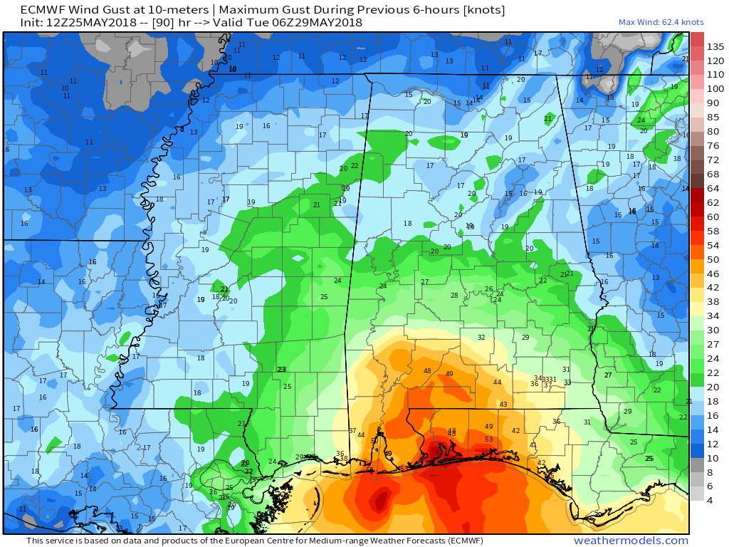
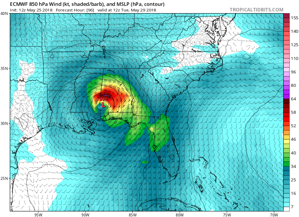
1. Regardless of its exact track and intensity, Alberto is expected
to produce heavy rainfall and flash flooding over the northeastern
Yucatan Peninsula of Mexico, western Cuba, southern Florida and the
Florida Keys. Rainfall and flooding potential will increase across
the central Gulf Coast region and the southeastern United States
later this weekend and early next week when Alberto is expected to
slow down after it moves inland.

2. Alberto could bring tropical storm conditions and storm surge to
portions of the central and eastern Gulf Coast later this weekend
and early next week, although it is too soon to specify the exact
location and magnitude of these impacts. Residents in these areas
should monitor the progress of Alberto, as tropical storm and storm
surge watches may be required later today or tonight.

3. Dangerous surf and rip current conditions are affecting portions
of the Yucatan Peninsula and western Cuba and will likely spread
along the eastern and central U.S. Gulf Coast later this weekend.

FORECAST POSITIONS AND MAX WINDS

INIT 25/1500Z 19.7N 86.8W 35 KT 40 MPH
12H 26/0000Z 20.5N 86.6W 35 KT 40 MPH
24H 26/1200Z 22.0N 86.2W 40 KT 45 MPH
36H 27/0000Z 24.1N 85.8W 45 KT 50 MPH
48H 27/1200Z 26.7N 86.1W 50 KT 60 MPH
72H 28/1200Z 29.3N 87.9W 55 KT 65 MPH
96H 29/1200Z 31.0N 89.1W 30 KT 35 MPH...INLAND
120H 30/1200Z 33.6N 88.7W 20 KT 25 MPH...INLAND

$$
Forecaster Stewart
 
Gfs is much slower this run. Looks more like the Euro

Sent from my SM-J327VPP using Tapatalk
 
One thing to watch for is if this thing maintains it's subtropical look even as it strengthens and eventually becomes fully tropical. We've seen this happen several times over the past ten years in early season gulf storms with meager TCHP. We've also see this setup produce very ugly strong TS and minimal hurricanes. If this occurrs you will have much larger impacts on the eastern side away from the center even more so than the usual TC and put the panhandle into SE AL into a training band of convection. It also may keep the wind field broader and up the tornado threat as well.
 
As mentioned by others, I don't understand why the name Alberto wasn't retired. Anyone know? Maybe this misunderstanding is due to my bias since the worst in 1994 occurred not too far away from me? Were the casualties not bad enough?? I know it isn't just because it was only a TS as the name, Allison, was retired after the bad flooding from TS Allison of 2001.
 
As mentioned by others, I don't understand why the name Alberto wasn't retired. Anyone know? Maybe this misunderstanding is due to my bias since the worst in 1994 occurred not too far away from me? Were the casualties not bad enough?? I know it isn't just because it was only a TS as the name, Allison, was retired after the bad flooding from TS Allison of 2001.

I really don't know either...
 
000
WTNT31 KNHC 251732
TCPAT1

BULLETIN
Subtropical Storm Alberto Intermediate Advisory Number 1A
NWS National Hurricane Center Miami FL AL012018
100 PM CDT Fri May 25 2018

...ALBERTO MEANDERING OVER THE NORTHWESTERN CARIBBEAN SEA...
...HEAVY RAINFALL EXPECTED TO AFFECT THE YUCATAN PENINSULA...WESTERN
CUBA...FLORIDA...AND THE NORTHEASTERN GULF COAST THROUGH THE
WEEKEND...


SUMMARY OF 100 PM CDT...1800 UTC...INFORMATION
----------------------------------------------
LOCATION...19.5N 86.5W
ABOUT 60 MI...95 KM S OF COZUMEL MEXICO
ABOUT 200 MI...320 KM SW OF THE WESTERN TIP OF CUBA
MAXIMUM SUSTAINED WINDS...40 MPH...65 KM/H
PRESENT MOVEMENT...STATIONARY
MINIMUM CENTRAL PRESSURE...1005 MB...29.68 INCHES


WATCHES AND WARNINGS
--------------------
CHANGES WITH THIS ADVISORY:

None.

SUMMARY OF WATCHES AND WARNINGS IN EFFECT:

A Tropical Storm Watch is in effect for...
* Tulum to Cabo Catoche Mexico
* Cuban province of Pinar del Rio

A Tropical Storm Watch means that tropical storm conditions are
possible within the watch area, in this case within the next 24
hours.

Interests along the central and eastern U.S. Gulf Coast should
monitor the progress of Alberto. Tropical storm and storm surge
watches could be required for portions of this area later today or
tonight.

For storm information specific to your area, please monitor
products issued by your national meteorological service.


DISCUSSION AND OUTLOOK
----------------------
At 100 PM CDT (1800 UTC), the center of Subtropical Storm Alberto
was located near latitude 19.5 North, longitude 86.5 West. The
storm has been nearly stationary during the past several hours.
However, a general slow motion toward the north is expected through
the weekend, followed by a northwest turn by Monday. On the foreast
track, Alberto is expected to pass near the eastern coast of the
Yucatan peninsula tonight, be near the western tip of Cuba Saturday
morning, emerge over the southeastern Gulf of Mexico by Saturday
night, and approach the north-central Gulf Coast on Monday.

Maximum sustained winds are near 40 mph (65 km/h) with higher
gusts. Gradual strengthening is forecast for the next 72 hours.

Winds of 40 mph extend outward up to 115 miles (185 km) from the
center.

The estimated minimum central pressure is 1005 mb (29.68 inches).


HAZARDS AFFECTING LAND
----------------------
RAINFALL: Alberto is expected to produce total rain accumulations
of 10 to 15 inches with isolated totals of 25 inches across the
northeastern portions of the Yucatan Peninsula and western Cuba.
These rains could produce life-threatening flash floods and
mudslides. Rainfall accmumulations of 4 to 8 inches with maximum
amounts of 12 inches are possible across the Florida Keys and
southern and southwestern Florida. Heavy rain will likely begin
to affect the central Gulf Coast region and the southeastern Untied
States later this weekend and continue into early next week.
Flooding potential will increase across this region early next
week as Alberto is forecast to slow down after it moves inland.

WIND: Tropical storm conditions are possible within the watch
area through Saturday.

SURF: Swells generated by Alberto are affecting portions of
the coast of eastern Yucatan Peninsula and western Cuba. These
swells are likely to cause life-threatening surf and rip current
conditions. Hazardous surf conditions are likely to develop along
much of the central and eastern U.S. Gulf Coast this weekend. For
more information, consult products from your local weather office.


NEXT ADVISORY
-------------
Next complete advisory at 400 PM CDT.

$$
Forecaster Stewart
 
Does the Euro this afternoon still have Alberto in Mobile Bay? My son and his Family live in Gulf Breeze so their interest is peaked to say the least.
 
000
URNT15 KNHC 251931
AF307 0101A ALBERTO HDOB 14 20180525
191930 1958N 08510W 8428 01556 0082 +170 +116 257010 011 018 000 03
192000 1956N 08511W 8426 01557 0082 +168 +115 263009 009 017 000 00
192030 1955N 08513W 8434 01551 0086 +165 +117 268008 009 018 000 00
192100 1954N 08514W 8427 01557 0086 +164 +118 257007 008 016 001 03
192130 1953N 08515W 8431 01553 0087 +164 +118 250007 007 016 000 00
192200 1952N 08516W 8433 01553 0088 +162 +126 247009 009 016 000 00
192230 1951N 08517W 8429 01557 0086 +161 +142 235009 010 017 000 00
192300 1950N 08519W 8429 01556 0087 +160 +140 232008 009 017 000 00
192330 1949N 08520W 8429 01557 0088 +157 +138 228007 007 016 000 00
192400 1947N 08521W 8430 01554 0087 +157 +149 211007 008 016 000 00
192430 1946N 08522W 8428 01557 0086 +156 +155 207007 007 017 000 01
192500 1945N 08523W 8433 01552 //// +156 //// 210007 007 017 000 01
192530 1944N 08525W 8430 01554 0086 +158 +156 218006 006 017 000 01
192600 1943N 08526W 8429 01557 //// +159 //// 206006 006 016 000 01
192630 1942N 08527W 8433 01551 0084 +161 +154 195005 007 016 000 01
192700 1941N 08528W 8430 01557 //// +160 //// 196005 006 016 000 01
192730 1940N 08529W 8429 01556 //// +160 //// 189005 005 016 000 01
192800 1938N 08531W 8434 01549 //// +159 //// 199004 006 017 000 01
192830 1937N 08532W 8430 01553 //// +159 //// 176004 005 015 001 01
192900 1936N 08533W 8430 01554 //// +160 //// 175005 005 015 000 01
$$
;
 
Back
Top